 Catalogue PIGMA
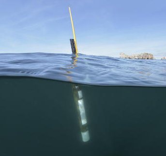
Argo float data and metadata from Global Data Assembly Centre (Argo GDAC)
Argo is a global array of 3,000 free-drifting profiling floats that measures the temperature and salinity of the upper 2000 m of the ocean. This allows, for the first time, continuous monitoring of the temperature, salinity, and velocity of the upper ocean, with all data being relayed and made publicly available within hours after collection.
The array provides 100,000 temperature/salinity profiles and velocity measurements per year distributed over the global oceans at an average of 3-degree spacing. Some floats provide additional bio-geo parameters such as oxygen or chlorophyll.
All data collected by Argo floats are publically available in near real-time via the Global Data Assembly Centers (GDACs) in Brest (France) and Monterey (California) after an automated quality control (QC), and in scientifically quality controlled form, delayed mode data, via the GDACs within six months of collection.
Simple
- Date (Publication)
- 2000-09-12
- Identifier
- 1282383d-9b35-4eaa-a9d6-4b0c24c0cfc9
- Credit
- Institut Français de Recherche pour l'Exploitation de la MER (France)
- Status
- onGoing On going
- Maintenance and update frequency
- As needed
- Theme
-
- float
- Argo
- global ocean observing system
- ocean circulation
- in-situ
- ocean pressure
- sea water salinity
- sea water temperature
- multi-year
- weather climate and seasonal observation
- global-ocean
- Sous-regions marines
-
- National
- Ocean Hackathon - Ville
-
- Brest
- Use limitation
- A user should acknowledge use of Argo data in all publications and products where such data are used, preferably with the following standard sentence:"These data were collected and made freely available by the international Argo project and the national programs that contribute to it."
- Access constraints
- Other restrictions
- Other constraints
- No limitations on public access
- Use limitation
- A user of Argo data is expected to read and understand this manual and the documentation about the data contained in the "attributes" of the NetCDF data files, as these contain essential information about data quality and accuracy.
- Unique resource identifier
- 10.5281/zenodo.6343858
- Association Type
- Cross reference
- Spatial representation type
- vector Vector
- Denominator
- 1000000
- Metadata language
- English
- Character set
- utf8 UTF8
- Topic category
-
- Oceans
))
- Begin date
- 1995
- Reference system identifier
- EPSG / WGS 84 (EPSG:4326) / 7.9
- Topology level
- Geometry only
- Geometric object type
- Point
- Geometric object count
- 1000000000
- Distribution format
-
-
(
)
-
(
)
- OnLine resource
- Coriolis Web Site ( WWW:LINK )
- OnLine resource
-
Argo GDAC snapshots access
(
DOI
)
Argo GDAC snapshots access
- OnLine resource
-
Web app avec carte interactive Flotteurs Argo opérationnels
(
WWW:LINK
)
Ocean-OPS: Web app tous les flotteurs opérationnels
- OnLine resource
- /home/ref-argo/gdac ( NETWORK:LINK )
- OnLine resource
- Argo Dashboard ( WWW:LINK )
- OnLine resource
-
FTP ARGO
(
WWW:DOWNLOAD
)
FTP ARGO
- OnLine resource
-
ERDDAP Download link
(
WWW:DOWNLOAD
)
ERDDAP Download link
- OnLine resource
-
GDAC
(
WWW:DOWNLOAD
)
GDAC
- Hierarchy level
- Dataset
Absolute external positional accuracy
Conformance result
- Date (Creation)
- 2012-01-16
- Explanation
- Non évalué
- Pass
- No
- Statement
- http://www.argodatamgt.org/Documentation
Overviews
Spatial extent
Provided by
