Catalogue PIGMA
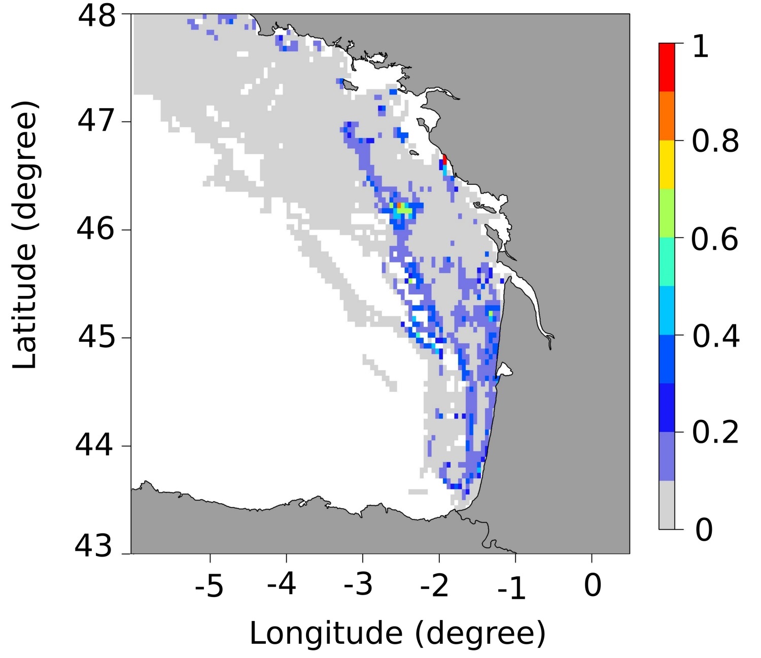
Spawning areas of seabass (Dicentrarchus labrax) in the Bay of Biscay
Simple
- Date (Publication)
- 2020-12-20
- Identificateur
- DOI:10.12770/4ca9f42a-af88-4a00-a553-32130a1b23a2
- Reconnaissance
- IFREMER - STH - LBH
- Thèmes Sextant
-
- /Biological Environment/Species/Fish Species of Commercial Interest
- GEMET - INSPIRE themes, version 1.0
-
- Habitats and biotopes
- Mots clés
-
- seabass
- sea bass
- essential fish habitat
- zone fonctionnelle
- Limitation d'utilisation
- CC-BY-NC-ND (Creative Commons - Attribution, Pas d’utilisation commerciale, Pas de modification)
- Contraintes d'accès
- Licence
- Contraintes d'utilisation
- Licence
- Type de représentation spatiale
- vector Vecteur
- Dénominateur de l'échelle
- 5000
- Langue
- English
- Jeu de caractères
- utf8 Utf8
- Catégorie ISO
-
- Océans
))
- Code
- EPSG:4326
- Type de géométries des objets
- Polygone
- Format (encodage)
-
-
(
)
-
(
)
- Ressource en ligne
-
Main publication
(
WWW:LINK-1.0-http--publication-URL
)
Dambrine, C., Woillez, M., Huret, M., & de Pontual, H. (2021). Characterising Essential Fish Habitat using spatio‐temporal analysis of fishery data: A case study of the European seabass spawning areas. Fish Oceanogr, 30: 413-428. https://doi.org/10.1111/fog.12527
- Ressource en ligne
-
DOI de la donnée
(
DOI
)
DOI de la donnée
- Ressource en ligne
-
IFR_STH_FRAYERES_BAR_GOLFE_DE_GASCOGNE_JANVIER
(
OGC:WMS
)
Frayères du bar - Janvier
- Ressource en ligne
-
IFR_STH_FRAYERES_BAR_GOLFE_DE_GASCOGNE_JANVIER
(
OGC:WFS
)
Frayères du bar - Janvier
- Ressource en ligne
-
IFR_STH_FRAYERES_BAR_GOLFE_DE_GASCOGNE_FEVRIER
(
OGC:WMS
)
Frayères du bar - Février
- Ressource en ligne
-
IFR_STH_FRAYERES_BAR_GOLFE_DE_GASCOGNE_FEVRIER
(
OGC:WFS
)
Frayères du bar - Février
- Ressource en ligne
-
IFR_STH_FRAYERES_BAR_GOLFE_DE_GASCOGNE_MARS
(
OGC:WMS
)
Frayères du bar - Mars
- Ressource en ligne
-
IFR_STH_FRAYERES_BAR_GOLFE_DE_GASCOGNE_MARS
(
OGC:WFS
)
Frayères du bar - Mars
- Ressource en ligne
-
IFR_STH_FRAYERES_BAR_GOLFE_DE_GASCOGNE_MOYENNE
(
OGC:WMS
)
Frayères du bar - Moyenne
- Ressource en ligne
-
IFR_STH_FRAYERES_BAR_GOLFE_DE_GASCOGNE_MOYENNE
(
OGC:WFS
)
Frayères du bar - Moyenne
- Niveau
- Jeu de données
Cohérence du domaine de valeurs
Résultat de conformité
- Date (Publication)
- 2010-12-08
- Explication
- See the referenced specification
- Généralités sur la provenance
-
These data were produced during a thesis carried out within the framework of the Barfray project financed by the European Fund for Fisheries and the Sea (FEAMP-OSIRIS N °: PFEA 400017DM0720006), France Filière Pêche (FFP), the French Ministry of Agriculture and Food (MAF) and Ifremer.
The idea was to improve the knowledge available on the spawning areas of European seabass (Dicentrarchus labrax) in the northeast Atlantic. To do so, we characterized the seabass spawning areas along the French Atlantic coast (English Channel and Bay of Biscay) using fishing data from geolocated vessels (VMS data provided by the Direction des Pêches Maritimes et de l'Aquaculture (DPMA) and the Système d'Informations Halieutiques (SIH) of Ifremer). A non-linear geostatistical approach was carried out over the years 2008-2013 to detect areas where seabass aggregate to reproduce. Spawning areas occurrence maps were produced for each month of the spawning season. These occurrence maps were summarised in average maps representing the probability of being a spawning area. These maps allow quantifying the seasonal and interannual variability, and highlight the recurrent, occasional and unfavourable spawning areas. An average map over all months of the spawning season was also produced to summarise the results and simplify the use.
- Identifiant de la fiche
- 4ca9f42a-af88-4a00-a553-32130a1b23a2 XML
- Langue
- English
- Jeu de caractères
- Utf8
- Identifiant de la fiche de métadonnées parent
- Zones fonctionnelles halieutiques d'importance (ZFHi) - Atlantique 7bbdd386-21dc-47cd-a4af-4f4c7583663b
- Type de ressource
- Jeu de données
- Date des métadonnées
- 2025-05-15T22:18:07.293783Z
- Nom du standard de métadonnées
- ISO 19115-3 - SEXTANT ISO 19115-3 - SEXTANT
- Version du standard de métadonnées
- 1.0