 Catalogue PIGMA
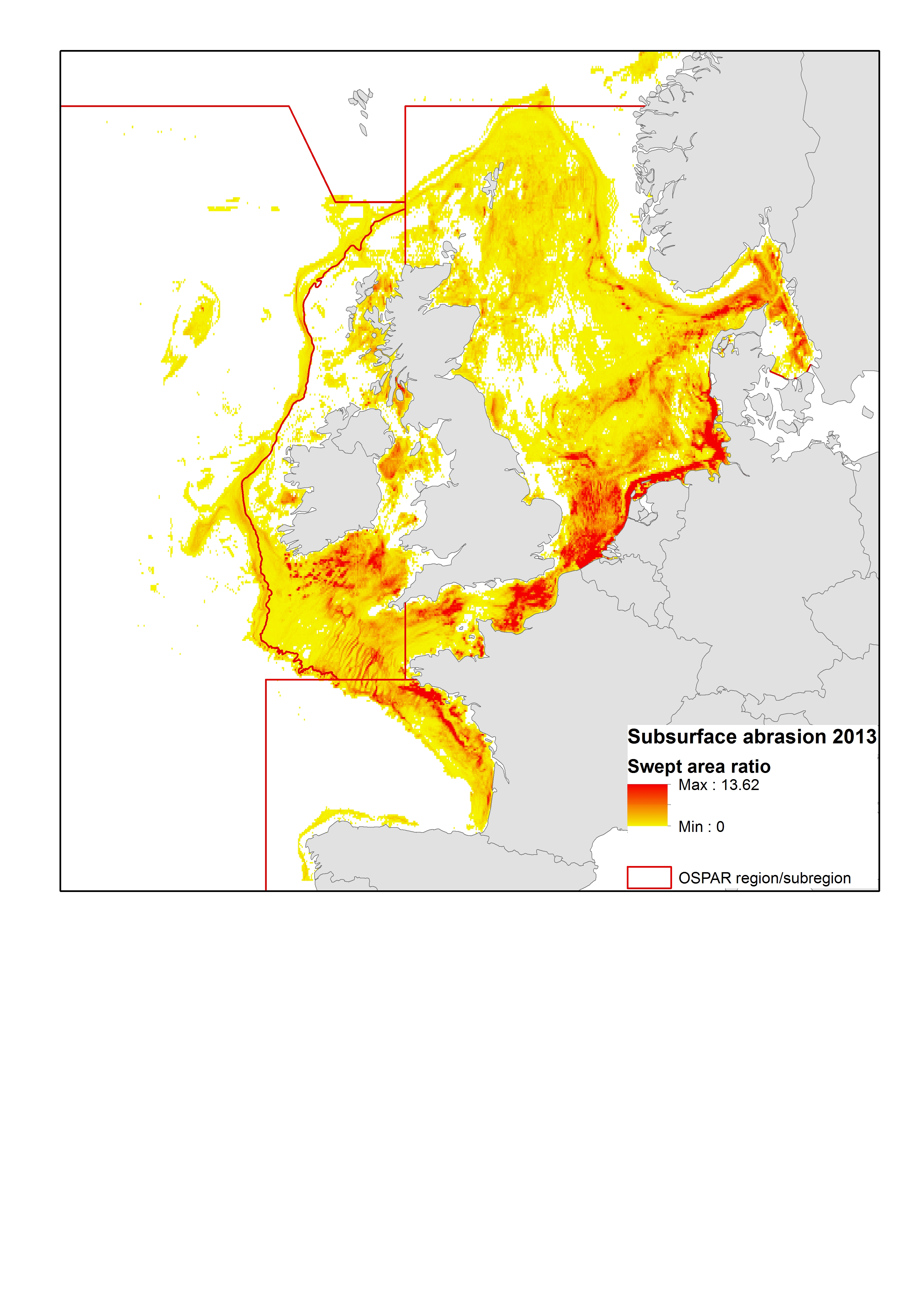
Fishing effort | High Resolution VMS & ERS (Logbook) Fishing Intensity Data | | OSPAR mapping fishing intensity and effort outputs 2015
Simple
- Alternate title
- OSPAR mapping fishing intensity and effort outputs 2015
- Date
- Identifier
- Fishing effort | High Resolution VMS & ERS (Logbook) Fishing Intensity Data | | OSPAR mapping fishing intensity and effort outputs 2015
- Other citation details
- OSPAR mapping fishing intensity and effort outputs 2015
- Purpose
- To illustrate the spatial and temporal coverage of OSPAR bottom fishing intensity in the NE Atlantic region
- Status
- onGoing On going
http://www.ices.dk/community/groups/Pages/WGSFD.aspx
- Maintenance and update frequency
- Unknown
- Used by challenges
-
- Atlantic - CH07 - Fisheries Impact
- Environmental matrix
-
- Human activities
- Production mode
-
- Delayed
- Visibility
-
- Use of open search engines, searching by name either the data provider or the characteristics
- Policy visibility
-
- There is detailed information provided to understand data policy
- Readyness
-
- Format not proprietary and content clearly specified (e.g. autodescriptive like ODV, NetCDF CF) or at least with appropriate document describing the content
- Parameter Discovery Vocabulary (P02)
-
- Fishing effort
- GEMET - INSPIRE themes, version 1.0
-
- Sea regions
- Processing level of characteristics
-
- High level analyzed
- Data delivery mechanisms
-
- Online discovery and downloading services
- Parameter Usage Vocabulary (other)
-
- High Resolution VMS & ERS (Logbook) Fishing Intensity Data
- Agreed Parameter Groups (P03)
-
- Human activity
- Service extent
-
- The datasets are referenced in a public national catalogue, in an international catalogue service
- Validation
-
- Draft
- Access constraints
- Other restrictions
- Other constraints
- Unrestricted
- Use limitation
- Open and Free. No charge
- Spatial representation type
- vector Vector
- Distance
- 17000 meter
- Metadata language
- Français
- Character set
- utf8 UTF8
- Topic category
-
- Oceans
- Environment description
- The impact of fishing on benthic habitats has previously been investigated however; a conclusive classification of potentially sensitive habitats per gear type does not exist. Currently only qualitative estimates of fishery impact using broad-scale habitat maps are possible. Here a sensitivity matrix using both fishing pressure and habitat sensitivity is employed to define pressure categories. A matrix-approach used to combine sensitivity and pressure is used to predict disturbance
))
- Begin date
- 2009
- End date
- 2013 After
Vertical extent
- Minimum value
- 0
- Maximum value
- 1000
- Number of dimensions
- 0
- Dimension name
- Time
- Resolution
- 5 year
- Transformation parameter availability
- Yes
- Checkpoint Availability
- Yes
- Distribution format
-
-
JPEG
()
-
ESRI Shapefile
()
-
PDF
()
-
ZIP
()
-
JPEG
()
- Hierarchy level
- Dataset
Domain consistency
- Name of measure
- Responsiveness
Quantitative result
- Value
- Online downloading (i.e. a few hours or less) for release
- Hierarchy level
- datasetComponent
))
- Begin date
- 2009
- End date
- 2016
Vertical extent
- Minimum value
- 0
- Maximum value
- 1000
- Other
- ATLANTIC_CH07_Product_2_2
Completeness omission
- Name of measure
- Horizontal Spatial Coverage
- Measure identification
- AP.1.1
- Measure description
- Horizontal coverage extent of product (eg : surface of the Mediterranean Sea)
Quantitative result
- Value type
- Real
- Value
- 568574.5
gmd:DQ_DescriptiveResult
- Date / Time
- 2018-02-01T00:00:00
- Statement
- Spatial coverage of data set
Completeness omission
- Name of measure
- Vertical Spatial Coverage
- Measure identification
- AP.1.2
- Measure description
- Vertical coverage extent of product
Quantitative result
- Value type
- Real
- Value
- 4539
gmd:DQ_DescriptiveResult
- Date / Time
- 2018-02-01T00:00:00
- Statement
- Max depth
Completeness omission
- Name of measure
- Temporal Coverage
- Measure identification
- AP.1.3
- Measure description
- Temporal coverage extent of product
Quantitative result
- Value type
- Integer
- Value
- 2921
gmd:DQ_DescriptiveResult
- Date / Time
- 2018-02-01T00:00:00
- Statement
- 8yrs
Completeness omission
- Name of measure
- Number of items
- Measure identification
- AP.1.4
- Measure description
- Count of all items in the dataset or sample. Describe the items which are counted. If the number is determined by sampling unit (density), define the sampling unit (eg size of mesh).
Quantitative result
- Value type
- Integer
gmd:DQ_DescriptiveResult
- Date / Time
- 2018-02-01T00:00:00
Conceptual consistency
- Name of measure
- Number of Characteristics
- Measure identification
- AP.2.1
- Measure description
- Number of characteristics in product
Quantitative result
- Value type
- Integer
gmd:DQ_DescriptiveResult
- Date / Time
- 2018-02-01T00:00:00
Thematic classification correctness
- Name of measure
- Horizontal resolution
- Measure identification
- AP.3.1
- Measure description
- Horizontal mesh size or equivalent value for the given scale of product (eg 50m for 1/50 000)
Quantitative result
- Value type
- Integer
gmd:DQ_DescriptiveResult
- Date / Time
- 2018-02-01T00:00:00
Thematic classification correctness
- Name of measure
- Vertical resolution
- Measure identification
- AP.3.2
- Measure description
- Average vertical sampling
Quantitative result
- Value type
- Real
gmd:DQ_DescriptiveResult
- Date / Time
- 2018-02-01T00:00:00
Thematic classification correctness
- Name of measure
- Temporal resolution
- Measure identification
- AP.3.3
- Measure description
- Temporal sampling interval of product
Quantitative result
- Value type
- Real
gmd:DQ_DescriptiveResult
- Date / Time
- 2018-02-01T00:00:00
Quantitative attribute accuracy
- Name of measure
- Thematic accuracy
- Measure identification
- AP.3.4
- Measure description
- Percentage error of the product and description of error concept for the product (100 words max) provided by expert
Quantitative result
- Value type
- Percentage
Temporal validity
- Name of measure
- Temporal validity
- Measure identification
- AP.4.1
- Measure description
- Max elapsed time between last input data records update and product creation date. Minimum value 1/24 day.
Quantitative result
- Value type
- Integer
gmd:DQ_DescriptiveResult
- Date / Time
- 2018-02-01T00:00:00
gmd:DQ_UsabilityElement
- Name of measure
- Usability
- Measure identification
- AP.5.1
gmd:DQ_DescriptiveResult
- Date / Time
- 2018-02-01T00:00:00
Completeness omission
- Name of measure
- Horizontal spatial coverage compliance
- Measure identification
- UD.APE.1.1
- Measure description
-
Percentage to which the extent of the horizontal spatial
coverage of the selected input data is not compliant with the DPS extent in km**2
(UD_AP_1_1 - DPS_AP_1_1)*100/DPS_AP_1_1
Quantitative result
- Value type
- Percentage
- Value
- -38.62657029548217
Completeness omission
- Name of measure
- Horizontal spatial coverage fitness for use error
- Measure identification
- UD.FU.1.1
- Measure description
-
Combination of the errors of the product
component Cn with the error of the selected input data set Ud Cn used for this component
- Value
- -38.62657029548217
Completeness omission
- Name of measure
- Vertical spatial coverage compliance
- Measure identification
- UD.APE.1.2
- Measure description
-
Percentage to which the vertical coverage of the selected
input data is not compliant with the DPS coverage extent in metres
(UD_AP_1_2 - DPS_AP_1_2)*100/DPS_AP_1_2
Quantitative result
- Value type
- Percentage
- Value
- 353.9
Completeness omission
- Name of measure
- Vertical spatial coverage fitness for use error
- Measure identification
- UD.FU.1.2
- Measure description
-
Combination of the errors of the product
component Cn with the error of the selected input data set Ud Cn used for this component
- Value
- 100
Completeness omission
- Name of measure
- Temporal coverage compliance
- Measure identification
- UD.APE.1.3
- Measure description
-
Percentage to which the time coverage of the selected input data is compliant with the DPS coverage extent in days
(UD_AP_1_3 - DPS_AP_1_3)*100/DPS_AP_1_3
Quantitative result
- Value type
- Percentage
- Value
- -19.972602739726028
Completeness omission
- Name of measure
- Temporal coverage fitness for use error
- Measure identification
- UD.FU.1.3
- Measure description
-
Combination of the errors of the product
component Cn with the error of the selected input data set Ud Cn used for this component
- Value
- -19.972602739726028
Completeness omission
- Name of measure
- Number of items compliance
- Measure identification
- UD.APE.1.4
- Measure description
-
Percentage to which the number of items of the selected input data is compliant with the DPS number of items in days
(UD_AP_1_4 - DPS_AP_1_4)*100/DPS_AP_1_4
Quantitative result
- Value type
- Percentage
Completeness omission
- Name of measure
- Error count fitness for use error
- Measure identification
- UD.FU.1.4
- Measure description
-
Combination of the errors of the product
component Cn with the error of the selected input data set Ud Cn used for this component
Thematic classification correctness
- Name of measure
- Horizontal resolution compliance
- Measure identification
- UD.APE.3.1
- Measure description
-
Percentage to which the horizontal resolution or equivalent scale value (eg 50 m for map scale of 1/50 000) data
or mean horizontal sampling interval of the selected input data is compliant not with the DPS horizontal
resolution
(DPS_AP_3_1 - UD_AP_3_1)*100/DPS_AP_3_1
Quantitative result
- Value type
- Percentage
Thematic classification correctness
- Name of measure
- Horizontal resolution fitness for use error
- Measure identification
- UD.FU.3.1
- Measure description
-
Combination of the errors of the product
component Cn with the error of the selected input data set Ud Cn used for this component
Thematic classification correctness
- Name of measure
- Vertical resolution compliance
- Measure identification
- UD.APE.3.2
- Measure description
-
Percentage to which the vertical sampling interval of the selected input data is not compliant with the DPS
vertical resolution
(DPS_AP_3_2 - UD_AP_3_2)*100/DPS_AP_3_2
Quantitative result
- Value type
- Percentage
Thematic classification correctness
- Name of measure
- Vertical resolution fitness for use error
- Measure identification
- UD.FU.3.2
- Measure description
-
Combination of the errors of the product
component Cn with the error of the selected input data set Ud Cn used for this component
Thematic classification correctness
- Name of measure
- Temporal resolution compliance
- Measure identification
- UD.APE.3.3
- Measure description
-
Percentage to which the temporal sampling interval
is not compliant with the DPS temporal sampling interval
(DPS_AP_3_3-UD_AP_3_3)*100/DPS_AP_3_3
Quantitative result
- Value type
- Percentage
Thematic classification correctness
- Name of measure
- Temporal resolution fitness for use error
- Measure identification
- UD.FU.3.3
- Measure description
-
Combination of the error of the product
component Cn with the error of the selected input data set Ud Cn used for this component
Quantitative attribute accuracy
- Name of measure
- Thematic accuracy compliance
- Measure identification
- UD.APE.3.4
- Measure description
-
Compliance of the value domain of
the accuracy of the selected input data with the value domain of the accuracy defined in DPS (% extracted from
thematic accuracy description)
UD_AP_3_4
Quantitative result
- Value type
- Percentage
Quantitative attribute accuracy
- Name of measure
- Thematic accuracy fitness for use error
- Measure identification
- UD.FU.3.4
- Measure description
-
Combination of the error of the product
component Cn with the error of the selected input data set Ud Cn used for this component
Temporal validity
- Name of measure
- Temporal validity compliance
- Measure identification
- UD.APE.4.1
- Measure description
-
Percentage to which the elapsed time between last selected input data record update is not compliant with the max
elapsed time specified in DPS
(DPS_AP_4_1 - UD_AP_4_1)*100/DPS_AP_4_1
Quantitative result
- Value type
- Percentage
Temporal validity
- Name of measure
- Temporal validity fitness for use error
- Measure identification
- UD.FU.4.1
- Measure description
-
Combination od errors of extent to which
the elapsed time between last selected input data record update and the product creation date is compliant with
the max elapsed time specified in DPS
- Attribute description
- observation
- Content type
- Physical measurement
- Description
- N\A
- File identifier
- 51ea93d0-7941-4bbe-80de-a09b7c102b1d XML
- Metadata language
- English
- Character set
- UTF8
- Hierarchy level
- Dataset
- Hierarchy level name
- Atlantic - CH07 - Fisheries Impact
- Date stamp
- 2018-03-14T12:18:21Z
- Metadata standard name
- ISO 19115-3 - Emodnet Checkpoint - Upstream Data
- Metadata standard version
- 1.0
Overviews
Spatial extent
Provided by
