 Catalogue PIGMA
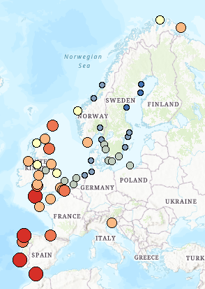
Change in the frequency of flooding events under projected sea level rise (RCP 4.5; change between 2010 and 2100; multiplication factor), Dec. 2016
This dataset presents the estimated multiplication factor by which the frequency of flooding events of a given height in European tide gauges will change between 2010 and 2100, due to projected regional sea relative level rise under the Representative Concentration Pathways (RCP) 4.5 scenario. Values larger than 1 indicate an increase in flooding frequency. This dataset is derived from the Figure 13.25(b) of the Working Group I contribution to the IPCC Fifth Assessment Report (http://www.climatechange2013.org/images/report/WG1AR5_ALL_FINAL.pdf).
This dataset also contributes to an earlier version of the EEA Indicator "Global and European sea-level": https://www.eea.europa.eu/data-and-maps/indicators/sea-level-rise-5/assessment.
Simple
- Date (Creation)
- 2016-06-25T00:00:00
- Date (Publication)
- 2016-12-20T00:00:00
- Edition
- 01.00
- Identifier
- eea_v_4326_10_mio_change-coastal-flooding_p_2010-2100_v01_r00
Point of contact
- Maintenance and update frequency
- Not planned
- Keywords
-
- Keywords
-
- Continents, countries, sea regions of the world.
-
- Switzerland
- EU28 (2013-2020)
- Iceland
- Norway
- Sous-regions marines
-
- /Métropole
- /Métropole/Manche mer du Nord
- /Métropole/Mers Celtiques
- /Métropole/Golfe de Gascogne
- /Métropole/Méditerranée occidentale
- Thématiques - SIMM
-
- /Etat du Milieu/Littoral
- Type de jeux de donnée - ODATIS
-
- /Données dérivées/Données de type modèle
- Type de jeux de donnée - ODATIS
-
- /Données dérivées/Indicateurs
Resource constraints
- Access constraints
- Other restrictions
- Other constraints
- no limitations to public access
- Use constraints
- Other restrictions
- Other constraints
-
License CC-BY 4.0 (https://creativecommons.org/licenses/by/4.0/).
Copyright holder: European Environment Agency (EEA) and for data sources: Intergovernmental Panel on Climate Change (IPCC), Antarctic Climate & Ecosystems Cooperative Research Centre.
- Spatial representation type
- vector Vector
- Denominator
- 10000000
- Metadata language
- English
- Topic category
-
- Environment
- Climatology, meteorology, atmosphere
- Begin date
- 2010-01-01
- End date
- 2100-12-31
))
- Unique resource identifier
- EPSG:4326
- Distribution format
-
-
SHP
(
)
-
SHP
(
)
- OnLine resource
- https://sdi.eea.europa.eu/webdav/datastore/public/eea_v_4326_10_mio_change-coastal-flooding_p_2010-2100_v01_r00/ ( EEA:FOLDERPATH )
- OnLine resource
- https://climate-adapt.eea.europa.eu/en/knowledge/tools/urban-adaptation ( WWW:LINK-1.0-http--link )
- OnLine resource
- Direct download ( WWW:URL )
- OnLine resource
- https://climate.discomap.eea.europa.eu/arcgis/services/UAMV/Projected_Change_Frequency_Coastal_Flooding/MapServer/WMSServer?request=GetCapabilities&service=WMS ( OGC:WMS )
- OnLine resource
- https://climate.discomap.eea.europa.eu/arcgis/rest/services/UAMV/Projected_Change_Frequency_Coastal_Flooding/MapServer ( ESRI:REST )
- OnLine resource
- EEA Indicator ( WWW:LINK-1.0-http--link )
- Hierarchy level
- Dataset
Domain consistency
Conformance result
- Date (Publication)
- 2010-12-08
- Explanation
- See the referenced specification
- Statement
-
Adapted from Figure 13.25(b) of the Working Group I contribution to the IPCC Fifth Assessment Report (http://www.climatechange2013.org/images/figures/WGI_AR5_Fig13-25.jpg). The dataset is based on the Summary of AR5 regional projections and allowances, from the Antarctic Climate & Ecosystems Cooperative Research Centre (http://www.acecrc.org.au/), 2014.
Sea-level data from tide gauges were supplied by European Sea-Level Service, Global Sea Level Observing System (GLOSS) Delayed Mode Centre, Helpdesk Water (Netherlands), Instituto Español de Oceanographia (Spain), Istituto Talassografico di Trieste (Italy), Marine Environmental Data Service (Canada), National Oceanography Centre Liverpool (UK), National Tidal Centre (Bureau of Meteorology, Australia), Norwegian Mapping Authority, Service Hydrographique et Océanographique de la Marine (France), Swedish Meteorological and Hydrological Institute and University of Hawaii Sea Level Centre (USA). Sea-level rise projections are based on the CMIP5 ensemble of global climate models.
More information about the methodology can be found here: http://dx.doi.org/10.1007/s10584-011-0332-1, http://dx.doi.org/10.1016/j.oceaneng.2012.12.041.
- File identifier
- 723f0742-727b-45ec-a70d-df6292b7e003 XML
- Metadata language
- English
- Character set
- UTF8
- Hierarchy level
- Dataset
- Date stamp
- 2025-10-09T10:57:29.641922Z
- Metadata standard name
- ISO 19115/19139
- Metadata standard version
- 1.0
Overviews
Spatial extent
Provided by
