 Catalogue PIGMA
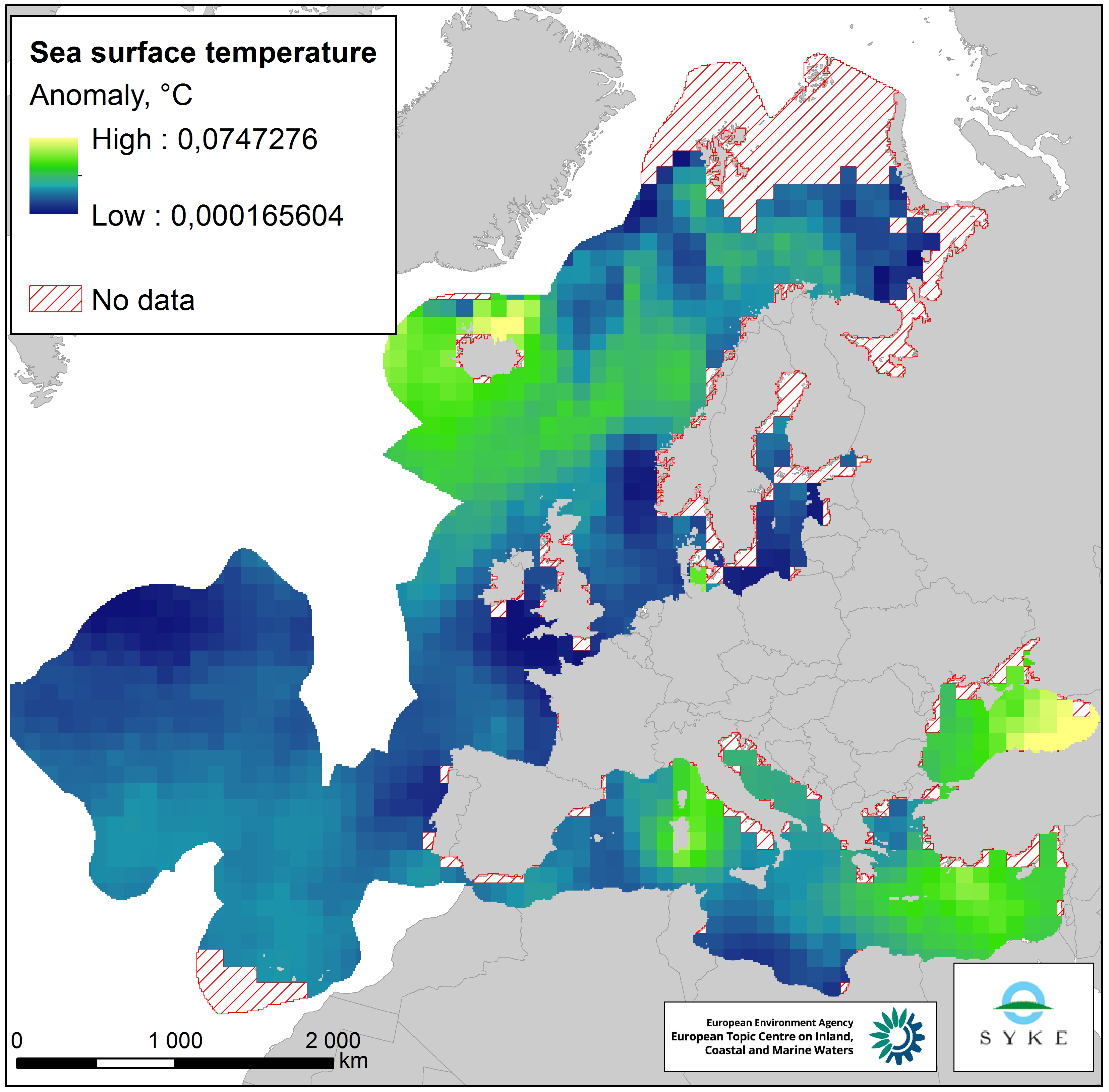
Sea surface temperature anomalies in Europe Seas, Jan. 2020
This raster dataset represents the Sea Surface Temperature (SST) anomalies, i.e. changes of sea temperatures, in the European Seas.
The dataset is based on the map "Mean annual sea surface temperature trend in European seas" by Istituto Nazionale di Geofisica e Vulcanologia (INGV), which depicts the linear trend in sea surface temperature (in °C/yr) for the European seas over the past 25 years (1989-2013).
Since all changes of sea temperatures can be considered to have an impact on the marine environment, the pressure layer includes absolute values of SST anomalies, i.e. negative/decreasing temperature trends were changed to positive values so that they represent a pressure. The original data was in a 1° grid format but was converted to a 100 km resolution, adapted to the EEA 10 km grid and clipped with the area of interest.
This dataset has been prepared for the calculation of the combined effect index, produced for the ETC/ICM Report 4/2019 "Multiple pressures and their combined effects in Europe's seas" available on: https://www.eionet.europa.eu/etcs/etc-icm/etc-icm-report-4-2019-multiple-pressures-and-their-combined-effects-in-europes-seas-1.
Simple
- Date (Creation)
- 2018-09-01
- Date (Publication)
- 2020-01-27
- Edition
- 01.00
- Identifier
- eea_r_3035_100_km_sst-anomalies_p_1989-2013_v01_r00
Point of contact
- Maintenance and update frequency
- As needed
- Keywords
-
- Keywords
-
- GEMET
-
- pressure
- sea
- temperature
- temperature change
- environmental pressure
- surface water
- Continents, countries, sea regions of the world.
-
- Mediterranean Sea
- Iceland Sea
- English Channel
- Norwegian Sea
- Black Sea
- North Sea
- Celtic Sea
- Ionian Sea
- Bay of Biscay
- Kattegat
- Adriatic Sea
- Baltic Sea
- Northeast Atlantic Ocean (40W)
- Barents Sea
- Spatial scope
-
- European
- EEA topics
-
- Extreme weather
- Seas and coasts
- Sous-regions marines
-
- /Métropole
- /Métropole/Manche mer du Nord
- /Métropole/Mers Celtiques
- /Métropole/Golfe de Gascogne
- /Métropole/Méditerranée occidentale
- Thématiques - SIMM
-
- /Etat du Milieu/Hydrodynamique
- Type de jeux de donnée - ODATIS
-
- /Données dérivées/Indicateurs
- Access constraints
- Other restrictions
- Other constraints
- no limitations to public access
- Use constraints
- Other restrictions
- Other constraints
- License CC-BY 4.0 (https://creativecommons.org/licenses/by/4.0/). Copyright holder: European Environment Agency (EEA).
- Spatial representation type
- grid Grid
- Distance
- 100 km
- Metadata language
- English
- Topic category
-
- Environment
- Oceans
))
- Begin date
- 1989-01-01
- End date
- 2013-12-31
- Unique resource identifier
- EPSG:3035
- Distribution format
-
-
GeoTIFF
(
)
-
GeoTIFF
(
)
- OnLine resource
- https://sdi.eea.europa.eu/webdav/datastore/public/eea_r_3035_100_km_sst-anomalies_p_1989-2013_v01_r00/ ( EEA:FOLDERPATH )
- OnLine resource
- Direct download ( WWW:URL )
- OnLine resource
- https://water.discomap.eea.europa.eu/arcgis/rest/services/Marine/Pressures_Sea_surface_temperature/MapServer ( ESRI:REST )
- Hierarchy level
- Dataset
Domain consistency
Conformance result
- Date (Publication)
- 2010-12-08
- Explanation
- See the referenced specification
- Statement
-
The dataset is based on the map "Mean annual sea surface temperature trend in European seas" by Istituto Nazionale di Geofisica e Vulcanologia (INGV), which depicts the linear trend in sea surface temperature (in °C/yr) for the European seas over the past 25 years (1989-2013). More information about this dataset here: https://www.eea.europa.eu/data-and-maps/figures/mean-annual-sea-surface-temperature-1.
The SST input data is based on bias adjusted in situ measurements. To extend the analysis over most of the data-sparse oceanic regions, reduced space optimal interpolation was applied (Kaplan et al. 1997).
Since all changes of sea temperatures can be considered to have an impact on the marine environment, the pressure layer includes normalised absolute values of SST anomalies.
The original data was in a 1° grid format but was converted to a 100km resolution raster - but adapted to the EEA 10 km grid to it could be clipped with and conform with the EEA 10 km shoreline.
- File identifier
- 789de867-c056-4f59-ac42-c7bbf71e662b XML
- Metadata language
- English
- Character set
- UTF8
- Hierarchy level
- Dataset
- Date stamp
- 2025-10-09T10:58:36.780667Z
- Metadata standard name
- ISO 19115/19139
- Metadata standard version
- 1.0
Overviews
Spatial extent
Provided by
