 Catalogue PIGMA
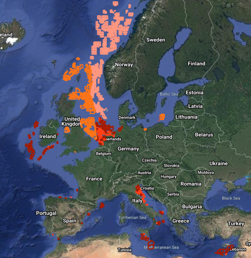
EMODnet Human Activities, Oil and Gas, Active Licences
Simple
- Date (Publication)
- 2014-06-30
- Date (Revision)
- 2020-10-05
- Date (Creation)
- 2014-06-24
- Identifier
- EMODnet_HA_OG_Active_Licences_20201005
- Credit
- European Marine Observation and Data Network
- GEMET - INSPIRE themes, version 1.0
-
- Energy resources
- Area management/restriction/regulation zones and reporting units
- GEMET - Themes, version 2.4
-
- energy
- GEMET - Concepts, version 3.1
-
- hydrocarbon
- oil exploration
- oil extraction
- offshore drilling
- oil production (chain)
- non-renewable energy resource
- natural gas extraction
- natural gas exploration
- Mission Atlantic - Resources
-
- Data
- Mission Atlantic - BODC Parameters
-
- /Human activities/Hydrocarbon extraction
- Mission Atlantic - Data type (DMP)
-
- Spatial data products
- Mission Atlantic - Case Studies
-
- Celtic Seas
- Mission Atlantic - Work Package
-
- WP3 Pelagic Mapping
- WP4 Benthic Mapping
- Use limitation
- Re-use of content for commercial or non-commercial purposes is permitted free of charge, provided that the sources (both EMODnet - Human Activities, and primary sources) are acknowledged. EMODnet - Human Activities accepts no responsibility or liability whatsoever for the re-use of content accessible on its website.
- Access constraints
- Other restrictions
- Other constraints
- no limitation
- Spatial representation type
- Vector
- Denominator
- 100000
- Metadata language
- EnglishEnglish
- Topic category
-
- Planning cadastre
- Utilities communication
))
- Reference system identifier
- EPSG:4326
- Reference system identifier
- ISO 19108 calendar
- Distribution format
-
-
ESRI Shapefile
(
1.0
)
-
ESRI Shapefile
(
1.0
)
- Transfer size
- 0
- OnLine resource
-
EMODnet Human Activities
(
WWW:LINK
)
EMODnet Human Activities aims to facilitate access to existing marine data on activities carried out in EU waters, by building a single entry point for geographic information on human uses of the ocean. The portal makes available information such as geographical position, spatial extent of a series of activities related to the sea, their temporal variation, time when data was provided, and attributes to indicate the intensity of each activity. The data are aggregated and presented so as to preserve personal privacy and commercially-sensitive information. The data also include a time interval so that historic as well as current activities can be included.
- OnLine resource
- Data access ( WWW:LINK )
- Hierarchy level
- Dataset
Conformance result
- Date (Publication)
- 2008-12-04
- Explanation
- See the referenced specification
- Pass
- Yes
Conformance result
- Date (Publication)
- 2010-12-08
- Explanation
- See the referenced specification
Conformance result
- Date (Publication)
- 2009-12-15
- Explanation
- See the referenced specification
- Pass
- Yes
- Statement
- Data were retrived from 13 different sources. Validation and quality assurance remain up to primary data sources, while harmonization is carried out by Cogea. The harmonisation process consisted of identifying a set of attributes common to all the different datasets, thus creating a single data model. To do so, it was necessary to define a homogenous set of variables for each attribute. Therefore, raw data attributes may use a different terminology, although the information contained remains basically the same. For further information on validation and quality assurance, it is suggested that primary data sources are contacted. Generally speaking data are to be considered very reliable, because they come from national sources officially in charge for their collection. In Spain, Gaviota is a storage licence (almacenamiento) that was harmonized as'other' type. When areas had to be calculated we used as much as possible the original projected coordinate system of the raw data or the UTM-WGS84 zone that the national data falls in.
Overviews
Spatial extent
Provided by
