 Catalogue PIGMA
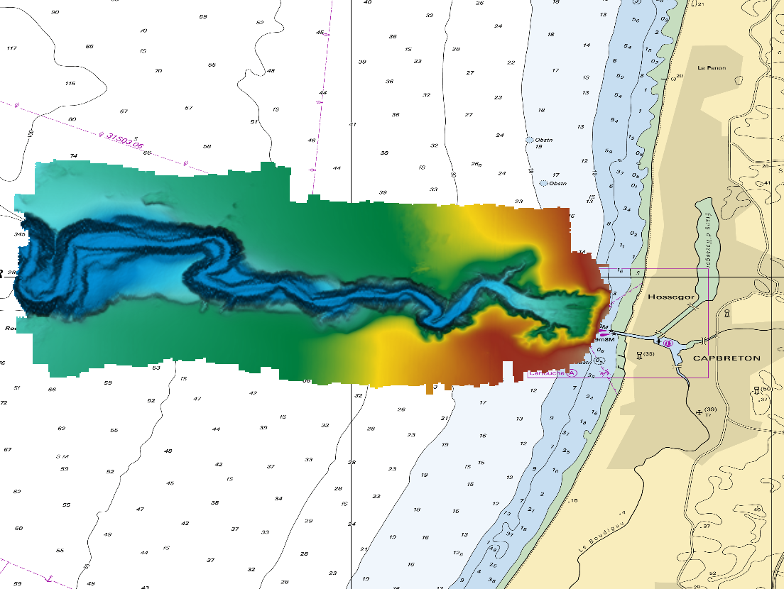
540_composite_DTM_1-64_Canyon
The DTM is a compilation of multibeam echosounder surveys acquired in 2013. The resolution is 1/64 arc-minutes (~30m). Surveys are located on the Capbreton Submarine Canyon (France) with depths from -4.7m to -344.9m. Depths are referenced to the Lowest Astronomical Tide and the coordinates are expressed into the WGS84 reference frame. The surveys which compose the DTM are S201306500-09 and S201306500-11. Data and metadata associated to these surveys are available on the website
http://diffusion.shom.fr/pro/lots-bathy.html.
The DTM is not to be used for navigation.
Simple
- Date (Creation)
- 2018-10-17T00:00:00
- Date (Revision)
- 2018-10-17T00:00:00
- Identifier
- DTM_1-64_Canyon
Originator
Shom
+33 (0)2 56.31.23.12
+33 (0)2 56.31.25.80
http://www.shom.fr/
13, rue du Chatellier
CS92803
, BREST CEDEX 2 , 29228 , France+33 (0)2 56.31.25.80
http://www.shom.fr/
Custodian
Shom
+33 (0)2 56.31.23.12
+33 (0)2 56.31.25.80
http://www.shom.fr/
13, rue du Chatellier
CS92803
, BREST CEDEX 2 , 29228 , France+33 (0)2 56.31.25.80
http://www.shom.fr/
- Parameter Discovery Vocabulary (P02)
-
- Bathymetry and Elevation
- SeaDataNet device categories
-
- multi-beam echosounders
- Vertical Datum
-
- Lowest Astronomical Tide
- Project name
-
- EMODnet HRSM
- Thèmes Sextant
-
- /Physical Environment/Bathymetry/Digital Terrain Model
- Access constraints
- Creative Commons Attribution 4.0 International
- Use constraints
- Other restrictions
- Other constraints
- DO NOT USE FOR NAVIGATION
- Spatial representation type
- Grid
- Denominator
- 10000
- Distance
- 0.015625 Arc minute
- Metadata language
- English
- Character set
- UTF8
- Topic category
-
- Oceans
- Begin date
- 2013-09-06T00:00:00
- End date
- 2013-09-08T00:00:00
Vertical extent
- Minimum value
- 4
- Maximum value
- 345
- Description
- Europe
N
S
E
W
))
- Reference system identifier
- EPSG / WGS 84 (EPSG:4326) / 7.4
- Number of dimensions
- 3
- Dimension name
- Column
- Dimension size
- 576
- Dimension name
- Row
- Dimension size
- 256
- Dimension name
- Time
- Dimension size
- 1
- Cell geometry
- Point
- Transformation parameter availability
- No
- Checkpoint Availability
- No
- Point in Pixel
-
- Center
- Distribution format
-
-
NetCDF
(
)
-
NetCDF
(
)
Distributor
Shom
+33 (0)2 56.31.23.12
+33 (0)2 56.31.25.80
http://www.shom.fr/
13, rue du Chatellier
CS92803
, BREST CEDEX 2 , 29228 , France+33 (0)2 56.31.25.80
http://www.shom.fr/
- Transfer size
- 6
- OnLine resource
-
DTM_1-64_Canyon - Format EMO
(
WWW:DOWNLOAD-1.0-link--download
)
DTM_1-64_Canyon - Format EMO
- OnLine resource
- EMODnet Bathymetry WMTS service ( WWW:LINK )
- OnLine resource
- EMODnet viewer ( WWW:LINK )
- Hierarchy level
- Dataset
Conformance result
- Date
- Explanation
- No
- Pass
- Yes
Quantitative attribute accuracy
- Name of measure
- depth
- Measure identification
- depth accuracy
Quantitative result
- Value
- not defined
Gridded data positional accuracy
- Name of measure
- horizontal accuracy
- Measure identification
- horizontal accuracy of coordinate
Quantitative result
- Value type
- horizontal accuracy
Absolute external positional accuracy
- Name of measure
- emodnet-bathymetry.QI.Horizontal
- Value
- 3 - < 20 m
Absolute external positional accuracy
- Name of measure
- emodnet-bathymetry.QI.Vertical
- Value
- 4 - MBES High frequency (higher that 100kHz) (1+0.5%d)
Domain consistency
- Name of measure
- emodnet-bathymetry.QI.Purpose
- Value
- 3 - Hydrographic survey or compatible with hydrographic standards
- Hierarchy level
- Software
- Other
- software
- Hierarchy level
- Property type
- Description
- parameters of data processing
- Description
- S201306500-09, S201306500-11
- File identifier
- SDN_CPRD_540_DTM_1-64_Canyon XML
- Metadata language
- English
- Character set
- UTF8
- Hierarchy level name
- Composite Product Record
- Date stamp
- 2022-09-21T07:00:28.262Z
- Metadata standard name
- ISO 19115:2003/19139 - EMODNET - BATHYMETRY
- Metadata standard version
- 1.0
Author
Shom
+33 (0)2 56.31.23.12
+33 (0)2 56.31.25.80
http://www.shom.fr/
13, rue du Chatellier
CS92803
, BREST CEDEX 2 , 29228 , France+33 (0)2 56.31.25.80
http://www.shom.fr/
Overviews
Canyon.PNG
Spatial extent
N
S
E
W
Provided by

Associated resources
Not available