 Catalogue PIGMA
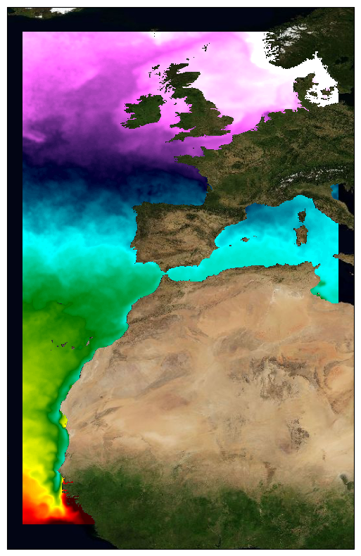
ODYSSEA North-East Atlantic High-Resolution Sea Surface Temperature Gridded Level 4 Daily Analysis, version 3, for the Copernicus Marine Service
This dataset provide a times series of daily multi-sensor composite fields of Sea Surface Temperature (SST) foundation at ultra-high resolution (HR) on a 0.02 x 0.02 degree grid (approximately 2 x 2 km) for the North East Atlantic, every 24 hours. An Optimal interpolation (OI) technique is used to combine coincident swath measures of SST from different types satellite sensors and to fill gaps where no observations are available or obstructed by clouds. This multi-sensor compositing and interpolation process categorizes this dataset as a Level 4 product. Each daily mean field is available the next day before 12:00.
Whereas along swath observation data essentially represent the skin or sub-skin SST, the L3S SST product is defined to represent the SST foundation (SSTfnd). SSTfnd is defined within GHRSST as the temperature at the base of the diurnal thermocline. It is so named because it represents the foundation temperature on which the diurnal thermocline develops during the day. SSTfnd changes only gradually along with the upper layer of the ocean, and by definition it is independent of skin SST fluctuations due to wind- and radiation-dependent diurnal stratification or skin layer response. It is therefore updated at intervals of 24 hrs. SSTfnd corresponds to the temperature of the upper mixed layer which is the part of the ocean represented by the top-most layer of grid cells in most numerical ocean models. It is never observed directly by satellites, but it comes closest to being detected by infrared and microwave radiometers during the night, when the previous day's diurnal stratification can be assumed to have decayed.
The processing combines the observations of multiple polar orbiting and geostationary satellites, embedding infrared of microwave radiometers. All these sources are intercalibrated with eachother before merging.
This dataset is generated daily within a 24 delay and is therefore suitable for assimilation into operational models.
It is produced in the frame of Copernicus Marine Service and the data available through various tools and protocols with a simple user registration from this service (product identifier: SST_ATL_SST_L4_NRT_OBSERVATIONS_010_025) at: https://data.marine.copernicus.eu/product/SST_ATL_SST_L4_NRT_OBSERVATIONS_010_025/
Simple
- Date (Publication)
- 2018-01-01
- Identifier
- SST_ATL_SST_L4_NRT_OBSERVATIONS_010_025 / v3.0
- Status
- onGoing On going
- GEMET - INSPIRE themes, version 1.0
-
- Oceanographic geographical features
- Cersat - Parameter
-
- Ocean Temperature
- Cersat - Project
-
- GHRSST
- CMEMS
- Theme
-
- CMEMS
- Cersat - Latency
-
- Less than 24 hours
- Cersat - GCMD parameter
-
- /Ocean Temperature/Sea Surface Temperature
- Centre de données ODATIS
-
- CDS-CERSAT
- Type de jeux de donnée ODATIS
-
- /Observational data/satellite
- ODATIS aggregation parameters and Essential Variable names
-
- Sea temperature
- Access constraints
- unrestricted
- Other constraints
- free and open
- Other constraints
- E Autret, JF Piollé, Ifremer / CERSAT. 2021. ODYSSEA North East Atlantic Ultra High-Resolution Sea Surface Temperature Gridded Level 4 Daily Analysis dataset (CMEMS/SST_ATL_SST_L4_NRT_OBSERVATIONS_010_025) (v3.0). Copernicus Marine Service. Dataset accessed [YYYY-MM-DD]. DOI: 10.48670/moi-00152
- Spatial representation type
- grid Grid
- Distance
- 0.02 degree
))
- Geographic identifier
- Europe / North East Atlantic
- Begin date
- 2018-01-01
- Reference system identifier
- http://www.opengis.net/def/crs/EPSG/0/4326
- Distribution format
-
-
NetCDF
(
4
)
-
NetCDF
(
4
)
- OnLine resource
-
Local path on Datarmor
(
NETWORK:LINK
)
Data access
- OnLine resource
- CMEMS FTP ( WWW:FTP )
- OnLine resource
-
CMEMS THREDDS
(
WWW:LINK
)
THREDDS
- OnLine resource
-
Ifremer FTP server
(
WWW:FTP
)
FTP
- OnLine resource
- Ifremer HTTP server ( WWW:LINK )
- OnLine resource
-
Processing and validation
(
WWW:LINK
)
Quality Information Document
- OnLine resource
-
User guide
(
WWW:LINK
)
Product User Manual
- OnLine resource
-
Product notices
(
WWW:LINK
)
Dataset Homepage on Copernicus Marine Service
- OnLine resource
-
Copernicus FTP
(
WWW:FTP
)
FTP
- OnLine resource
- Syntool ( WWW:LINK )
- OnLine resource
- Copernicus MOTU ( WWW:LINK )
- OnLine resource
-
Ifremer THREDDS
(
WWW:LINK
)
THREDDS
- OnLine resource
- Digital Object Identifier (DOI) ( DOI )
- Hierarchy level
- Series
- Date / Time
- v3.0 2018-01-01
- Hierarchy level
- Dataset
- Attribute description
- composite
- Processing level code
- L4 /
- File identifier
- bd26dcad-2576-49cb-8b0a-e2a94af688e3 XML
- Metadata language
- English
- Character set
- UTF8
- Hierarchy level
- Series
- Date stamp
- 2024-10-15T14:57:03.475009Z
- Metadata standard name
- ISO 19115-3:2018 - Remote Sensing
Overviews
Spatial extent
Provided by
