 Catalogue PIGMA
BENTHOSCOPE2 - Article: Three-dimensional mapping of the benthic invertebrates biophony with a compact four-hydrophones array
BENTHOSCOPE2 - Article: Cartographie tridimensionnelle de la biophonie des invertébrés benthiques avec un réseau compact de quatre hydrophones
Simple
-
Date (Publication)Date (Publication)
- 2022-08-05
-
IdentificateurIdentifier
- https://www.france-energies-marines.org/c126b9d0-79c1-449f-bc8f-03943710765e
-
CreditReconnaissance
-
FEMFEM
-
EtatStatus
-
FinaliséCompleted
-
ThèmeTheme
-
-
BiophonieBiophony
-
France Energies MarinesFrance Energies Marines
-
Invertébrés benthiquesBenthic invertebrates
-
-
GEMET - INSPIRE themes, version 1.0
-
-
Environmental monitoring facilitiesInstallations de suivi environnemental
-
-
France Energies Marines - Data Types
-
-
/Documents/Journal Article/Documents/Article scientifique
-
-
France Energies Marines - Facades
-
-
/Metropolitan France/France métropolitaine
-
/Metropolitan France/North Atlantic - Western Channel/France métropolitaine/Nord Atlantique - Manche Ouest
-
/Metropolitan France/Mediterranean Sea/France métropolitaine/Méditerranée
-
/Metropolitan France/South Atlantic/France métropolitaine/Sud Atlantique
-
/Metropolitan France/Eastern Channel - North Sea/France métropolitaine/Manche Est - Mer du Nord
-
-
France Energies Marines - Projects
-
-
/FEM/BENTHOSCOPE2/FEM/BENTHOSCOPE2
-
-
France Energies Marines - Technologies
-
-
Tidal energyHydrolien marin
-
Wave energyHoulomoteur
-
Fixed offshore windÉolien offshore fixe
-
Ocean thermal energyÉnergie thermique des mers
-
Floating offshore windÉolien flottant
-
-
France Energies Marines - Themes
-
-
BenthosBenthos
-
-
Contraintes d'accèsAccess constraints
-
Autres restrictionsOther restrictions
-
Other constraintsAutres contraintes
-
No limitations to public accessPas de restriction d'accès public
-
Use limitationLimitation d'utilisation
-
Free use subject to mentioning the source (at least the name of the producer) and the date of its last updateUtilisation libre sous réserve de mentionner la source (a minima le nom du producteur) et la date de sa dernière mise à jour
-
Contraintes d'utilisationUse constraints
-
Autres restrictionsOther restrictions
-
Other constraintsAutres contraintes
-
Supplier partner is not able to guarantee the accuracy, update, integrity, completeness of data and in particular that they are free of errors or inaccuracies, including location, identification or qualification. No warranty as to the fitness of the data for a particular purpose is made by the supplier partner. Users use the data under their full responsibility, without recourse against the supplier partner whose liability can be incurred due to damage resulting directly or indirectly from the use of this data. In particular, it is up to users to decide, on their own responsibility: the opportunity to use the data; File compatibility of their computer systems; adequacy of the data to their needs; that they have sufficient competence to use the data. The partner supplier is in no way responsible for external elements including data analysis tools, hardware, software, networks ... used to view and / or process data. The user ensures verify the timeliness of the information provided is compatible with the use of it.Le partenaire fournisseur n’est pas en mesure de garantir l’exactitude, la mise à jour, l’intégrité, l’exhaustivité des données et en particulier qu'elles sont exemptes d'erreurs ou d'imprécisions, notamment de localisation, d’identification ou de qualification. Aucune garantie quant à l'aptitude des données à un usage particulier n'est apportée par le partenaire fournisseur. Les utilisateurs utilisent les données sous leur responsabilité pleine et entière, sans recours possible contre le partenaire fournisseur dont la responsabilité ne saurait être engagée du fait d’un dommage résultant directement ou indirectement de l’utilisation de ces données. En particulier, il appartient aux utilisateurs d’apprécier, sous leur seule responsabilité : l'opportunité d'utiliser les données; la compatibilité des fichiers avec leurs systèmes informatiques; l’adéquation des données à leurs besoins; qu’ils disposent de la compétence suffisante pour utiliser les données. Le fournisseur partenaire n’est en aucune façon responsable des éléments extérieurs aux données et notamment des outils d’analyse, matériels, logiciels, réseaux..., utilisés pour consulter et/ou traiter les données. L’utilisateur veille à vérifier que l’actualité des informations mises à disposition est compatible avec l’usage qu’il en fait.
Résolution spatiale
Spatial resolution
-
LangueMetadata language
- FrenchFrançais
-
Jeu de caractèresCharacter set
-
Utf8UTF8
-
Catégorie ISOTopic category
-
-
Informations géoscientifiquesGeoscientific information
-
OcéansOceans
-
EnvironnementEnvironment
-
))
- Begin date
- 2021
- End date
- 2021
Information sur le système de référence
Reference System Information
-
Format (encodage)Distribution format
-
-
pdfpdf( 1.0 )
-
-
Ressource en ligneOnLine resource
-
Three-dimensional mapping of the benthic invertebrates biophony with a compact four-hydrophones array Cartographie tridimensionnelle de la biophonie des invertébrés benthiques avec un réseau compact de quatre hydrophones
(
WWW:LINK-1.0-http--publication-URL
)
Online articleArticle en ligne
-
Ressource en ligneOnLine resource
-
FEM project webpage Page web du projet FEM
(
WWW:LINK
)
FEM project webpagePage web du projet FEM
-
NiveauHierarchy level
-
documentdocument
Résultat de conformité
Conformance result
-
Date (Publication)Date (Publication)
- 2010-12-08
-
ExplanationExplication
-
Article 7, paragraph 1, of Directive 2007/2 / EC corresponds to the technical procedures for interoperability: this is the regulation on interoperability: regulation n ° 1253/2013 of 21 October 2013 amending and supplementing Regulation n ° 1089/2010 of 23 November 2010L’article 7, paragraphe 1, de la directive 2007/2/CE correspond aux modalités techniques de l’interopérabilité : il s’agit du règlement relatif à l’interopérabilité : règlement n°1253/2013 du 21 octobre 2013 modifiant et complétant le règlement n°1089/2010 du 23 novembre 2010
-
Degré de conformitéPass
- Yes
-
StatementGénéralités sur la provenance
-
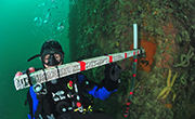
Benthic invertebrates emit broadband transient sounds, that dominate coastal soundscapes and can inform on the environment and its ecological state. Numerous works have studied temporal patterns of Benthic Invertebrate Biophonies (BIB) and linked them to environmental parameters or ecological processes, but there is a lack of knowledge about the spatial variability of BIB. Here, we mapped Benthic Invertebrate Sounds (BIS) in three dimensions using a compact array (2 m × 2 m × 2 m) of four hydrophones within the scope of eco-acoustics studies. Firstly, we developed tools to localize any individual sound emitted by benthic invertebrates. A theoretical calculation of the Cramer Rao Bounds (CRB) consolidated by in situ active emissions from known positions, demonstrated the accuracy of the localization. Secondly, by accumulating all the positions of the BIS recorded during a night, three methods are proposed to map the BIB at different spatial scales. An in situ measurement campaign carried out on a 300 m × 300 m artificial reef system revealed that the marine fauna was binary spatially distributed: rich and numerous on artificial reefs and poor and weak outside the reefs. At small ranges (10 m), the acoustic maps matched the geometric structures of the reefs with an accuracy of 0.5 m. At large scales (100 m and 300 m), the acoustic hot-spots on the maps corresponded to distant reefs, with an accuracy of 7 m and 10 m respectively.
Partners of the project: France Energies Marines, INP Grenoble, Chorus, LEMAR, UBO, CNRS, RTsys and TBM.
Funding: This work was supported by France Energies Marines and the French government by its National Agency for Research under the Future Investments Program (ANR-10-IEED-0006-05).
Les invertébrés benthiques émettent des sons transitoires à large bande, qui dominent les paysages sonores côtiers et peuvent informer sur l'environnement et son état écologique. De nombreux travaux ont étudié les schémas temporels des biophonies des invertébrés benthiques (BIB) et les ont liés à des paramètres environnementaux ou à des processus écologiques, mais il existe un manque de connaissances sur la variabilité spatiale des BIB. Ici, nous avons cartographié les sons des invertébrés benthiques (BIS) en trois dimensions à l'aide d'un réseau compact (2 m × 2 m × 2 m) de quatre hydrophones dans le cadre d'études éco-acoustiques. Dans un premier temps, nous avons développé des outils pour localiser tout son individuel émis par les invertébrés benthiques. Un calcul théorique des limites de Cramer Rao (CRB) consolidées par des émissions actives in situ à partir de positions connues, a démontré la précision de la localisation. Dans un second temps, en cumulant toutes les positions du BIS enregistrées au cours d'une nuit, trois méthodes sont proposées pour cartographier le BIB à différentes échelles spatiales. Une campagne de mesures in situ réalisée sur un système de récifs artificiels de 300m×300m a révélé que la faune marine était répartie spatialement de manière binaire : riche et nombreuse sur les récifs artificiels et pauvre et faible en dehors des récifs. Aux petites distances (10 m), les cartes acoustiques correspondent aux structures géométriques des récifs avec une précision de 0,5 m. Aux grandes échelles (100m et 300m), les points chauds acoustiques sur les cartes correspondaient à des récifs lointains, avec une précision de 7m et 10m respectivement.
Partenaires du projet : France Energies Marines, INP Grenoble, Chorus, LEMAR, UBO, CNRS, RTsys et TBM.
Financement : Ce travail a bénéficié d’une aide de France Energies Marines et de l’Etat gérée par l’Agence Nationale de la Recherche au titre du programme Investissements d’Avenir (ANR-10-IEED-0006-05).
-
Identifiant de la ficheFile identifier
- c126b9d0-79c1-449f-bc8f-03943710765e XML
-
LangueMetadata language
- EnglishEnglish
-
Jeu de caractèresCharacter set
-
Utf8UTF8
- Parent identifier
- BENTHOSCOPE 2 - Project Sheet 73f944a7-1b77-4cca-ae29-dd2af92ce103
-
Type de ressourceHierarchy level
-
documentdocument
- Hierarchy level name
- Parent
-
Date des métadonnéesDate stamp
- 2022-08-05T10:03:42.051Z
- Metadata standard name
- ISO 19115
- Metadata standard version
- 1.0
Overviews
Spatial extent
Provided by
