 Catalogue PIGMA
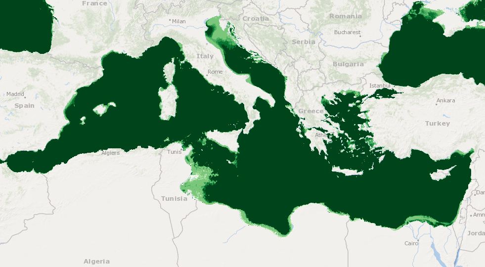
MEDSEA_CH2_Product_5 / Representativity of habitats/species/other features
Simple
- Date (Creation)
- 2016-12-08T00:00:00
- Date (Revision)
- 2016-12-08T00:00:00
- Identifier
- DOI:10.12770/df4d3c78-c10e-4149-bcb7-7c0185b2f506
- Issue identification
- MEDSEA D3.3.5
- Purpose
- Representativity of habitats/species/other features
- Credit
- EMODnet Medsea Checkpoint
- Used by challenges
-
- MedSea - CH02 - Marine Protected Areas
- Processing level of characteristics
-
- High level analyzed
- Production mode
-
- Delayed
- GEMET - INSPIRE themes, version 1.0
-
- Habitats and biotopes
- Theme
-
- Marine Protected Areas
- MPAs
- Habitats
- species
- Bathymetry
- Cetaceans
- Natura sites
- light
- coralligenous formations
- Posidonia oceanica
- marine caves
- Transitional water bodies
- substrate
- Mediterranean
- Aggregate Datasetindentifier
- c2511569-04b0-4b5e-9a87-1f3de3fc7366
- Association Type
- Cross reference
- Initiative Type
- specification
- Aggregate Datasetindentifier
- 88ef998b-3b02-4858-ac0e-4fb01cd12be3
- Association Type
- Cross reference
- Initiative Type
- upstreamData
- Aggregate Datasetindentifier
- aeb9913b-9a4f-416f-a2ce-270cc6ef0e6a
- Association Type
- Cross reference
- Initiative Type
- upstreamData
- Aggregate Datasetindentifier
- d255deba-9d62-4612-99af-7b14868c2880
- Association Type
- Cross reference
- Initiative Type
- upstreamData
- Aggregate Datasetindentifier
- 6aa04103-d99f-4a26-a5c9-5d4effe6012c
- Association Type
- Cross reference
- Initiative Type
- upstreamData
- Aggregate Datasetindentifier
- df075b62-3af0-45d3-87a3-dab77fdcca7b
- Association Type
- Cross reference
- Initiative Type
- upstreamData
- Aggregate Datasetindentifier
- e433b2ba-9726-45ea-a8a3-30f8f24114b8
- Association Type
- Cross reference
- Initiative Type
- upstreamData
- Aggregate Datasetindentifier
- 6a1b86ae-4938-4e49-8a0c-384f296b2c14
- Association Type
- Cross reference
- Initiative Type
- upstreamData
- Aggregate Datasetindentifier
- 867a7f29-a9b5-4808-8aa5-f1039992a3f4
- Association Type
- Cross reference
- Initiative Type
- upstreamData
- Aggregate Datasetindentifier
- 41c7d2aa-60bb-470b-ba5a-80c09c84993b
- Association Type
- Cross reference
- Initiative Type
- upstreamData
- Aggregate Datasetindentifier
- d875fb2f-5b5d-47ec-8749-3a4528c43ea6
- Association Type
- Cross reference
- Initiative Type
- upstreamData
- Spatial representation type
- vector Vector
- Metadata language
- English
- Character set
- utf8 UTF8
- Topic category
-
- Oceans
))
- Begin date
- 1933-12-01T00:00:00
- End date
- 2014-12-31T00:00:00 After
Vertical extent
- Minimum value
- 0
- Maximum value
- 5200
- Reference system identifier
- http://www.opengis.net/def/crs/EPSG/0/4326
- Distribution format
-
-
ESRI Shapefile
()
-
ESRI Shapefile
()
- OnLine resource
-
DOI of the product
(
WWW:LINK-1.0-http--metadata-URL
)
DOI of the product
- OnLine resource
-
CH2_product_5
(
OGC:OWS-C
)
Product visualization
- OnLine resource
-
Access to the website
(
WWW:LINK
)
Access to the website
- Hierarchy level
- datasetComponent
- Begin date
- 1933-01-01T00:00:00
Vertical extent
- Minimum value
- 0
- Maximum value
- 5200
- Other
- MEDSEA_CH2_Product_5
- Other
- Combination of bathymetry, light, MPAs, Natura sites, seagrass distributions, Coralligenous formations, Mediterranean Cetaceans, Marine caves, Transitional water bodies
- Other
- Seabed - Riverbed|Habitat characterisation||High level analyzed|Delayed
- Other
- Biota - Biology|Administrative units||Other|Delayed
- Other
- Seabed - Riverbed|Administrative units||Publication|Delayed
- Other
- Seabed - Riverbed|Administrative units||Publication|Delayed
- Other
- Seabed - Riverbed|Administrative units||Publication|Delayed
- Other
- Seabed - Riverbed|Bathymetry and Elevation||Other|Delayed
- Other
- Biota - Biology|Habitat extent||Other|Delayed
- Other
- Marine water|Cetacean behaviour||Other|Delayed
- Other
- Seabed - Riverbed|Light extinction and diffusion coefficients||High level analyzed|Delayed
Completeness omission
- Name of measure
- Horizontal Spatial Coverage
- Measure identification
- AP.1.1
- Measure description
- Horizontal coverage extent of product (eg : surface of the Mediterranean Sea)
Quantitative result
- Value type
- Real
- Value
- 2500000
Completeness omission
- Name of measure
- Vertical Spatial Coverage
- Measure identification
- AP.1.2
- Measure description
- Vertical coverage extent of product
Quantitative result
- Value type
- Real
- Value
- 5200
Completeness omission
- Name of measure
- Temporal Coverage
- Measure identification
- AP.1.3
- Measure description
- Temporal coverage extent of product
Quantitative result
- Value type
- Integer
- Value
- 365
Conceptual consistency
- Name of measure
- Number of Characteristics
- Measure identification
- AP.2.1
- Measure description
- Number of characteristics in product
Quantitative result
- Value type
- Integer
- Value
- 9
Thematic classification correctness
- Name of measure
- Horizontal resolution
- Measure identification
- AP.3.1
- Measure description
- Horizontal mesh size or equivalent value for the given scale of product (eg 50m for 1/50 000)
Quantitative result
- Value type
- Integer
- Value
- 255055
Thematic classification correctness
- Name of measure
- Vertical resolution
- Measure identification
- AP.3.2
- Measure description
- Average vertical sampling
Quantitative result
- Value type
- Real
- Value
- 0
gmd:DQ_DescriptiveResult
- Date / Time
- 2016-12-02T00:00:00
Thematic classification correctness
- Name of measure
- Temporal resolution
- Measure identification
- AP.3.3
- Measure description
- Temporal sampling interval of product
Quantitative result
- Value type
- Real
- Value
- 0
Quantitative attribute accuracy
- Name of measure
- Thematic accuracy
- Measure identification
- AP.3.4
- Measure description
- Percentage error of the product and description of error concept for the product (100 words max) provided by expert
Quantitative result
- Value type
- Percentage
- Value
- 40
Temporal validity
- Name of measure
- Temporal validity
- Measure identification
- AP.4.1
- Measure description
- Max elapsed time between last input data records update and product creation date
Quantitative result
- Value type
- Integer
- Value
- 0
Completeness omission
- Name of measure
- Horizontal spatial coverage error
- Measure identification
- P.APE.1.1
- Measure description
-
Percentage to which the extent of the horizontal
spatial coverage of TPD is not compliant with the DPS extent in km**2(TDP_AP_1_1 - DPS_AP_1_1)*100/DPS_AP_1_1
Quantitative result
- Value type
- Percentage
- Value
- 0
Completeness omission
- Name of measure
- Vertical spatial coverage error
- Measure identification
- P.APE.1.2
- Measure description
-
Percentage to which the extent of the vertical spatial coverage of TPD is not compliant with the DPS extent in
metres.(TDP_AP_1_2 - DPS_AP_1_2)*100/DPS_AP_1_2
Quantitative result
- Value type
- Percentage
- Value
- 0
Completeness omission
- Name of measure
- Temporal coverage error
- Measure identification
- P.APE.1.3
- Measure description
-
Percentage to which the extent of the temporal coverage of TPD is not compliant with the DPS extent in
days.(TDP_AP_1_3 - DPS_AP_1_3)*100/DPS_AP_1_3
Quantitative result
- Value type
- Percentage
- Value
- -98.79518072289157
Conceptual consistency
- Name of measure
- Thematic content error
- Measure identification
- P.APE.2.1
- Measure description
-
Percentage
of completeness/Incompleteness of the number of characteristcs with respect to the list in DPS(TDP_AP_2_1 - DPS_AP_2_1)*100/DPS_AP_2_1
Quantitative result
- Value type
- Percentage
- Value
- -10
Thematic classification correctness
- Name of measure
- Horizontal resolution error
- Measure identification
- P.APE.3.1
- Measure description
-
Percentage to which the product averaged horizontal mesh size or horizontal scale is not compliant with the DPS
averaged mesh size or horizontal scale(DPS_AP_3_1 - TDP_AP_3_1)*100/DPS_AP_3_1
Quantitative result
- Value type
- Percentage
- Value
- -101922
Thematic classification correctness
- Name of measure
- Vertical resolution error
- Measure identification
- P.APE.3.2
- Measure description
-
Percentage to which the product averaged vertical mesh size or vertical scale is not compliant with the DPS
averaged mesh size or vertical scale(DPS_AP_3_2 - TDP_AP_3_2)*100/DPS_AP_3_2
Quantitative result
- Value type
- Percentage
- Value
- 100
Thematic classification correctness
- Name of measure
- Temporal sampling interval error
- Measure identification
- P.APE.3.3
- Measure description
-
Percentage to which the product temporal sampling interval is not compliant with the one defined in DPS
(percentage to be extracted from text of AP.3.3 measure)(DPS_AP_3_3 - TDP_AP_3_3)*100/DPS_AP_3_3
Quantitative result
- Value type
- Percentage
- Value
- 100
Quantitative attribute accuracy
- Name of measure
- Thematic accuracy errror
- Measure identification
- P.APE.3.4
- Measure description
-
Compliance with the value domain of
the accuracy defined in DPS (% extracted from thematic accuracy description)TDP_AP_3_4
Quantitative result
- Value type
- Percentage
- Value
- 40
Temporal validity
- Name of measure
- Temporal validity error
- Measure identification
- P.APE.4.1
- Measure description
-
Percentage to which the elapsed time of the product is not compliant with the max elapsed time specified in
DPS.(DPS_AP_4_1 - TDP_AP_4_1)*100/DPS_AP_4_1
Quantitative result
- Value type
- Percentage
- Value
- 100
- File identifier
- df4d3c78-c10e-4149-bcb7-7c0185b2f506 XML
- Metadata language
- English
- Character set
- UTF8
- Hierarchy level
- Dataset
- Date stamp
- 2025-01-28T09:15:33.991972Z
- Metadata standard name
- ISO 19115-3 - Emodnet Checkpoint - Targeted Data Product
Overviews
Spatial extent
Provided by
