 Catalogue PIGMA
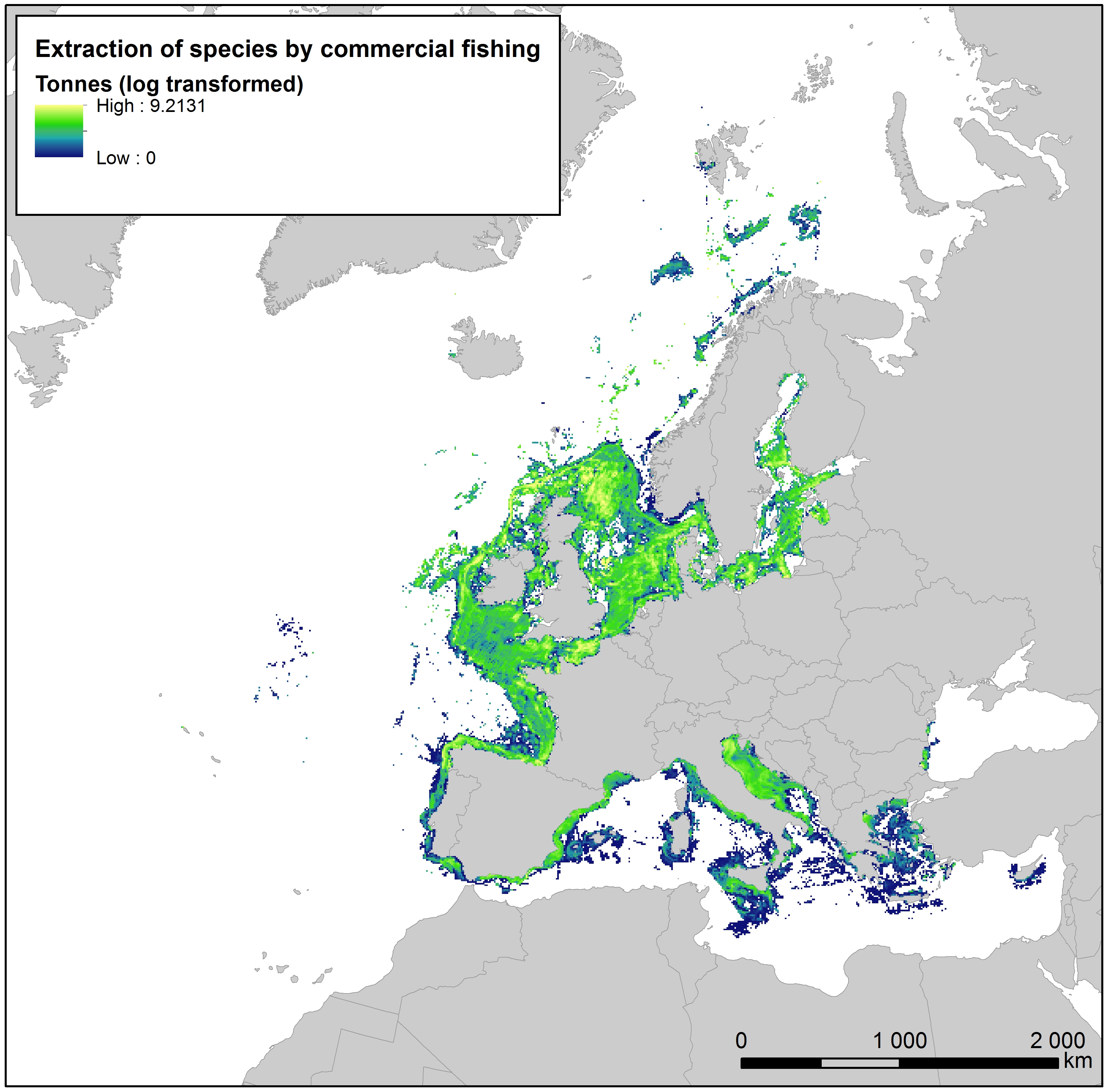
Extraction of species by commercial fishing in Europe Seas, Jan. 2020
This raster dataset provides the estimation of the extracted tonnes of fish by commercial fishing per 10 km grid cell in the European seas.
The dataset has been derived from the combination of demersal and pelagic fishing data, together with fish landings data (2011-2016) from the European Commission’s Joint Research Centre - Independent experts of the Scientific, Technical and Economic Committee for Fisheries (JRC STECF). The temporal extent varies between the data sources. The cell values have been transformed to a logarithmic scale (ln1).
This dataset has been prepared for the calculation of the combined effect index, produced for the ETC/ICM Report 4/2019 "Multiple pressures and their combined effects in Europe's seas" available on: https://www.eionet.europa.eu/etcs/etc-icm/etc-icm-report-4-2019-multiple-pressures-and-their-combined-effects-in-europes-seas-1.
Simple
- Date (Creation)
- 2019-05-01
- Date (Publication)
- 2020-01-27
- Edition
- 01.00
- Identifier
- eea_r_3035_10_km_commer-fish_p_2011-2016_v01_r00
Point of contact
- Maintenance and update frequency
- As needed
- Keywords
-
- Keywords
-
- GEMET
-
- pressure
- fishery
- fishing
- sea
- environmental pressure
- Continents, countries, sea regions of the world.
-
- Celtic Sea
- Bay of Biscay
- Norwegian Sea
- North Sea
- Northeast Atlantic Ocean (40W)
- Iceland Sea
- Baltic Sea
- Black Sea
- English Channel
- Adriatic Sea
- Ionian Sea
- Mediterranean Sea
- Kattegat
- Barents Sea
- Spatial scope
-
- European
- EEA topics
-
- Biodiversity
- Fisheries and aquaculture
- Sustainability challenges
- Production and consumption
- Sous-regions marines
-
- /Métropole
- /Métropole/Manche mer du Nord
- /Métropole/Mers Celtiques
- /Métropole/Golfe de Gascogne
- /Métropole/Méditerranée occidentale
- Thématiques - SIMM
-
- /Activités et Usages/Pêche et Aquaculture
- Thématiques - SIMM
-
- /Etat du Milieu/Pollutions
- Type de jeux de donnée - ODATIS
-
- /Données dérivées/Produits composites
- Access constraints
- Other restrictions
- Other constraints
- no limitations to public access
- Use constraints
- Other restrictions
- Other constraints
-
License CC-BY 4.0 (https://creativecommons.org/licenses/by/4.0/). Copyright holder: European Environment Agency (EEA).
Furthermore, and as a data product derived from demersal and pelagic fishing intensity data downloaded from the HELCOM Map and Data service, it can be used freely given that the source is cited (ICES. 2017. Spatial data layers of fishing intensity/pressure per gear type for surface and subsurface abrasion, for the years 2009 and 2016 in the HELCOM area).
- Spatial representation type
- grid Grid
- Distance
- 10 km
- Metadata language
- English
- Topic category
-
- Environment
- Oceans
))
- Begin date
- 2011-01-01
- End date
- 2016-12-31
- Unique resource identifier
- EPSG:3035
- Distribution format
-
-
GeoTIFF
(
)
-
GeoTIFF
(
)
- OnLine resource
- https://sdi.eea.europa.eu/webdav/datastore/public/eea_r_3035_10_km_commer-fish_p_2011-2016_v01_r00/ ( EEA:FOLDERPATH )
- OnLine resource
- Direct download ( WWW:URL )
- Hierarchy level
- Dataset
Domain consistency
Conformance result
- Date (Publication)
- 2010-12-08
- Explanation
- See the referenced specification
- Statement
- The dataset was created by aggregating the datasets bycatch by bottom touching mobile gears and bycatch by pelagic towed gears, and with the use of fish landings data (2011-2016) from the European Commission’s Joint Research Centre - Independent experts of the Scientific, Technical and Economic Committee for Fisheries (JRC STECF). Then the amount of tonnes of fish extracted was calculated per 10 km grid cell. The cell values have been transformed to a logarithmic scale (ln1).
- File identifier
- e99610ad-8fdb-44f2-a671-ccf9ec13c252 XML
- Metadata language
- English
- Character set
- UTF8
- Hierarchy level
- Dataset
- Date stamp
- 2025-10-09T11:20:51.552299Z
- Metadata standard name
- ISO 19115/19139
- Metadata standard version
- 1.0
Overviews
Spatial extent
Provided by
