 Catalogue PIGMA
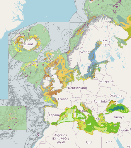
EUSeaMap (2019) Broad-Scale Predictive Habitat Map - EUNIS classification
Output of the 2019 EUSeaMap broad-scale predictive model, produced by EMODnet Seabed Habitats.
The extent of the mapped area includes the Mediterranean Sea, Black Sea, Baltic Sea, and areas of the North Eastern Atlantic extending from the Canary Islands in the south to the Barents Sea in the north.
The map was produced using a "top-down" modelling approach using classified habitat descriptors to determine a final output habitat.
Habitat descriptors differ per region but include:
Biological zone
Energy class
Oxygen regime
Salinity regime
Seabed substrate
Riverine input
Habitat descriptors (excepting Substrate) are calculated using underlying physical data and thresholds derived from statistical analyses or expert judgement on known conditions.
The model is produced using R and Arc Model Builder (10.1).
The model was created using raster input layers with a cell size of 0.00104dd (roughly 100 metres). The model includes the sublittoral zone only; due to the high variability of the littoral zone, a lack of detailed substrate data and the resolution of the model, it is difficult to predict littoral habitats at this scale.
This map follows the EUNIS 2007-11 classification system where it is appropriate. It has also been classified according to MSFD Benthic Broad Habitat types.
This report details the methods used in the previous version (v2016) - a new report is in progress:
Populus J. And Vasquez M. (Eds), 2017. EUSeaMap, a European broad-scale seabed habitat map. Ifremer
Available from: http://archimer.ifremer.fr/doc/00388/49975/
Simple
- Date (Publication)
- 2019-05-03
- Date (Creation)
- 2019-05-03
- Credit
- European Marine Observation and Data Network
- Status
- Completed
- DCSMM : Descripteurs
-
- D1: Biodiversité - Céphalopodes
- D1: Biodiversité - Poissons
- D6: Intégrité des fonds marins
- D7: Changements hydrographiques
- Sous-regions marines
-
- Métropole
- Thématiques - SIMM
-
- /Etat du Milieu/Habitats
- GEMET - INSPIRE themes, version 1.0
-
- Habitats and biotopes
- Mission Atlantic - Case Studies
-
- Celtic Seas
- North Mid-Atlantic Ridge
- Norwegian Sea
- Mission Atlantic - Work Package
-
- WP4 Benthic Mapping
- Mission Atlantic - Data type (DMP)
-
- Spatial data products
- Mission Atlantic - BODC Parameters
-
- /Environment/Habitat
- Thèmes Sextant
-
- /Biological Environment/Habitats
- Mission Atlantic - Resources
-
- Data
- Use limitation
- CC-BY 4.0
- Access constraints
- Other restrictions
- Use constraints
- Copyright
- Other constraints
- Please use attribution statement included within: EMODnet broad-scale seabed habitat map for Europe (v2019), licensed under CC-BY 4.0 from the European Marine Observation and Data Network (EMODnet) Seabed Habitats initiative (www.emodnet-seabedhabitats.eu), funded by the European Commission.
- Denominator
- 250000
- Metadata language
- English
- Topic category
-
- Biota
- Environment
- Oceans
))
- Begin date
- 1975-01-01
- End date
- 2019-05-03
- Reference system identifier
- EPSG / WGS 84 (EPSG:4326) / 7.4
- Distribution format
-
-
Web Mapping Service
(
1.1.0
)
-
Web Mapping Service
(
1.1.0
)
- OnLine resource
- EMODnet Seabed Habitats Download page (EUSeaMap preselected) ( WWW:LINK )
- OnLine resource
-
EMODnet Seabed Habitats interactive map
(
OGC:WMS-1.1.1-http-get-map
)
EUSeaMap 2019 on the EMODnet Seabed Habitats interactive map
- OnLine resource
-
215_seabed%20habitats.png
(
WWW:DOWNLOAD-1.0-http--download
)
EMODnet Seabed Habitats broad scale habitat maps (EUSeaMap 2019) Techical report and MSFD Benthic Broad Habitat types Look up tables
- Hierarchy level
- Dataset
Conformance result
- Date (Publication)
- Pass
- Statement
-
Previous version published in 2016. This map has been updated using up-to-date input layers and extended to include the Barents Sea.
An accompanying confidence layer is available for viewing and download from EMODnet Seabed Habitats.
Details on method for the 2016 version available from: http://archimer.ifremer.fr/doc/00388/49975/ A new report is in progress.
- File identifier
- 01bf1f24-fdcd-4ee7-af8b-e62cf72fe2f9 XML
- Metadata language
- English
- Character set
- MD_CharacterSetCode_utf8
- Hierarchy level
- Dataset
- Date stamp
- 2022-02-23T11:03:04.889Z
- Metadata standard name
- ISO19115
- Metadata standard version
- 2003/Cor.1:2006
Overviews
Spatial extent
Provided by
