 Catalogue PIGMA
Globcurrent Combined (Absolute Geostrophic + Ekman) Surface Current Velocities over Global Ocean on a 6-hourly 0.25° Resolution Grid, version 3
Simple
- Date (Creation)
- 2014-01-01
- Identifier
- CLS-L4-CUReul_hs-ALT_SUM-v01.0
- Credit
- CERSAT
02 98 22 45 33
- Centre de données ODATIS
-
- CDS-CERSAT
- Keywords
-
- Type de jeux de donnée ODATIS
-
- /Données d'observation/satellite
- ODATIS aggregation parameters and Essential Variable names
-
- Courants
- Use limitation
- Aucune condition ne s’applique
- Access constraints
- Other restrictions
- Use constraints
- Copyright
- Spatial representation type
- grid Grid
- Metadata language
- Français
- Character set
- utf8 UTF8
- Topic category
-
- Oceans
))
- Begin date
- 1993-01-01
- End date
- 2017-05-15
- Geometric object type
- Complex
- Distribution format
-
-
(
)
-
(
)
- OnLine resource
- CERSAT Catalogue ( WWW:LINK )
- OnLine resource
- User manual for GlobCurrent Eulerian (combined geostrophy + Ekman) currents ( WWW:LINK )
- OnLine resource
- User manual for GlobCurrent Ekman currents ( WWW:LINK )
- OnLine resource
- User manual for GlobCurrent Absolute Geostrophic currents ( WWW:LINK )
- OnLine resource
- GlobCurrent Analysis and Interpretation Framework ( WWW:LINK )
- OnLine resource
- ESA Globcurrent Portal ( WWW:LINK )
- Hierarchy level
- Dataset
- Statement
-
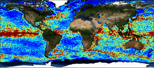
Ocean Surface Currents (OSC) can be considered as the cumulative results of local and remote factors, including highly variable winds, surface and internal waves, tides, mixed layer depth and buoyancy fluxes. Interacting with larger scale flows, the influence of these random forces on OSC is not trivial. As often observed, this can lead to well ordered and long lived coherent mesoscale structures, with horizontal scales of 30-300 km, and with time scales of 3-30 days. But, local and non-local interactions also induce transient frontal sub-mesoscale structures, developing complicated patterns with eddies, filaments and shear currents with horizontal scales of 1-10 km, vertical scales of 50-200 m, and ephemeral time scales of 1-3 days.
Although surface currents in the ocean are not the simple addition of different current components, in this first version of GlobCurrent products the combined currents are intended as the sum (referred to as total current) of the geostrophic and the Ekman components at the surface. Another product provides similar combined currents at 15m depth. The geostrophic and ekman components are available independently in two other different GlobCurrent products.
25 years of data are available, spanning the period from the beginning of 1993 to the end of 2017, on a 1/25° resolution grid and with a 3-hourly temporal resolution. More details on the calculation of the single components of this combined current can be found in the GlobCurrent Algorithm Theoretical Baseline Document, in the geostrophic currents handbooks and in the Ekman currents handbook. In particular, it should be noted that despite the high temporal (3-hourly) and spatial (1/25°) resolution of the GlobCurrent products grids, by construction, the effective resolution of the geostrophic and Ekman currents is of the order of 5-10 days / 50-100 km. These resolutions will be improved in the future versions of the GlobCurrent products. In addition, due to the reduced accuracy of altimeter measurements in coastal areas, users should be aware that some geostrophic velocities in very local areas close to the coast may be erroneous. These velocities will be flagged in the future versions of the GlobCurrent products.
- File identifier
- 3c2761a6-ec4d-420a-842c-3ccc936813cf XML
- Metadata language
- Français
- Character set
- UTF8
- Hierarchy level
- Dataset
- Date stamp
- 2025-05-15T22:02:57.480562Z
- Metadata standard name
- ISO 19115-3 - SEXTANT
- Metadata standard version
- 1.0
Overviews
Spatial extent
Provided by
