 Catalogue PIGMA
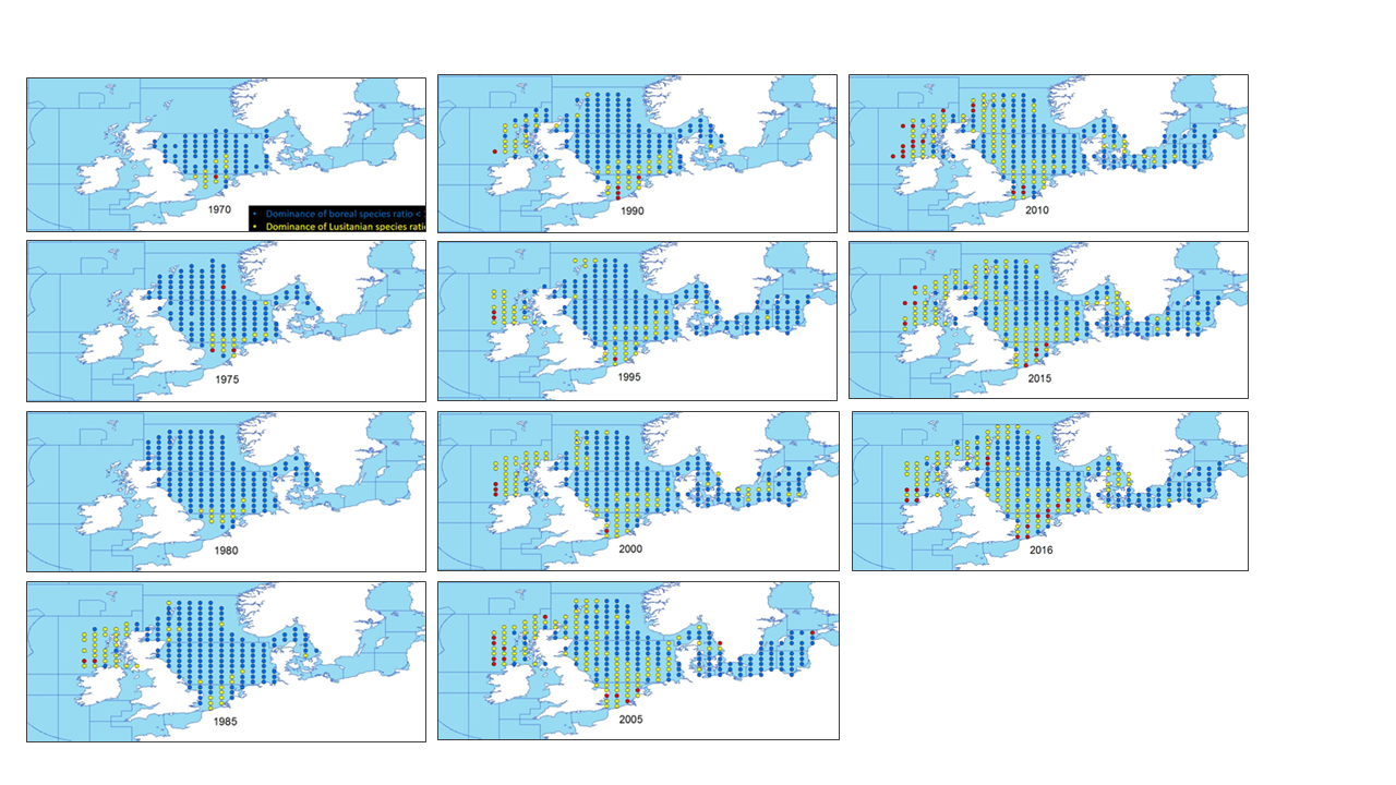
Temporal development of the ratio between the number of warm-favouring (Lusitanian) fish species and the number of cool-favouring (Boreal) fish species (1965-2016), May. 2020
This metadata describes the ICES data on the temporal development of the Lusitanian/Boreal species ratio in the period from 19657 to 2016.
Key message: The ratio between the number of Lusitanian (warm-favouring) and Boreal (cool-favouring) species are significantly increasing in several North-East Atlantic marine areas whereas there is no significant changes in all the southern areas. Changes in ratios are most apparent in the North Sea, Irish Sea and West of Scotland. Furthermore, it seems that Lusitanian species have not spread in all northward directions, but have followed two particular routes, through the English Channel and north around Scotland
Blue dots indicates L/B ratios below 1 (dominance of Boreal species)
Yellow dots indicates L/B ratios >=1 and <2 (dominance of Lusitanian species)
Red dots indicates L/B ratios >=2 (high dominance of Lusitanian species)
The dataset is derived from the ICES data portal 'DATRAS' (the Database of Trawl Surveys). DATRAS is an online database of trawl surveys with access to standard data products. DATRAS stores data collected primarily from bottom trawl fish surveys coordinated by ICES expert groups. The survey data are covering the Baltic Sea, Skagerrak, Kattegat, North Sea, English Channel, Celtic Sea, Irish Sea, Bay of Biscay and the eastern Atlantic from the Shetlands to Gibraltar. At present, there are more than 56 years of continuous time series data in DATRAS, and survey data are continuously updated by national institutions.
The dataset has been used in the EEA Indicator "Changes in fish distribution in European seas" https://www.eea.europa.eu/data-and-maps/indicators/fish-distribution-shifts/assessment-1.
The dataset has been used for this static map: https://www.eea.europa.eu/en/analysis/indicators/changes-in-fish-distribution-in/temporal-development-of-the-ratio
Simple
- Date (Creation)
- 2020-01-07
- Date (Publication)
- 2020-05-27
- Edition
- 01.00
- Identifier
- eea_v_4258_arcmin_lb-species-ratio_p_1965-2016_v01_r00
- Status
- superseded superseded
Point of contact
- Maintenance and update frequency
- Annually
- Keywords
-
- Keywords
-
- GEMET
-
- animal species
- migratory fish
- fishery
- climate
- Continents, countries, sea regions of the world.
-
- Skagerrak
- Central Baltic Sea
- Bay of Biscay
- English Channel
- Celtic Sea
- Atlantic Ocean
- Irish Sea
- Kattegat
- North Sea
- MSFD subregion
- Spatial scope
-
- European
- EEA topics
-
- Seas and coasts
- Fisheries and aquaculture
- Climate
- Temporal resolution
-
- Continual
- Sous-regions marines
-
- /Métropole
- /Métropole/Manche mer du Nord
- /Métropole/Mers Celtiques
- /Métropole/Golfe de Gascogne
- /Métropole/Méditerranée occidentale
- Thématiques - SIMM
-
- /Etat du Milieu/Espèces
- Thématiques - SIMM
-
- /Etat du Milieu/Habitats
- Type de jeux de donnée - ODATIS
-
- /Données dérivées/Produits composites
- Access constraints
- Other restrictions
- Other constraints
- no limitations to public access
- Use constraints
- Other restrictions
- Other constraints
-
ICES data can be downloaded for free. Detailed terms of use can be accessed here: https://www.ices.dk/data/guidelines-and-policy/Pages/ICES-data-policy.aspx.
Users must acknowledge data sources from ICES, as it is not ethical to publish data without proper attribution or co-authorship. Any person making substantial use of data must communicate with the data provider prior to publication, and should possibly consider the data provider(s) for co-authorship of published results.
License CC-BY 4.0 (https://creativecommons.org/licenses/by/4.0/). Copyright holder: European Environment Agency (EEA).
- Spatial representation type
- vector Vector
- Distance
- 30 arcmin
- Distance
- 1 deg
- Metadata language
- English
- Topic category
-
- Environment
- Biota
- Oceans
))
- Begin date
- 1965-01-01
- End date
- 2016-12-31
- Unique resource identifier
- EPSG:4258
- Distribution format
-
-
SHP
(
)
-
SHP
(
)
- OnLine resource
- https://sdi.eea.europa.eu/webdav/datastore/public/eea_v_4258_arcmin_lb-species-ratio_p_1965-2016_v01_r00/ ( EEA:FOLDERPATH )
- OnLine resource
-
EEA web site
(
WWW:LINK-1.0-http--link
)
Interactive map time series
- OnLine resource
- Direct download ( WWW:URL )
- OnLine resource
- https://www.arcgis.com/home/webmap/viewer.html?url=https%3A%2F%2Fmarine.discomap.eea.europa.eu%2Farcgis%2Frest%2Fservices%2FMarine%2FTime_line_WISE_Marine%2FMapServer&source=wms ( OGC:WMS )
- OnLine resource
- https://marine.discomap.eea.europa.eu/arcgis/rest/services/Marine/Time_line_WISE_Marine/MapServer ( ESRI:REST )
- Hierarchy level
- Dataset
Conformance result
- Date (Publication)
- 2010-12-08
- Explanation
- See the referenced specification
- Statement
-
The dataset is based on the ICES statistical rectangles. ICES statistical rectangles provide a grid covering the area between 36°N and 85°30'N and 44°W and 68°30'E. The dataset describes the center coordinate of the rectangles. More information about the ICES statistical rectangles can be accessed here:
https://www.ices.dk/data/maps/Pages/ICES-statistical-rectangles.aspx
The dataset is extracted from DATRAS which is an online database of trawl surveys with access to standard data products. DATRAS (the Database of Trawl Surveys) has been developed to collate and document the survey data, assure data quality, standardise data formats and calculations, and ease data handling and availability. With the possibility for instant remote access, the data from DATRAS are used for stock assessments and fish community studies by the ICES community and public users. More information about DATRAS can be accessed here: https://www.ices.dk/data/data-portals/Pages/DATRAS.aspx.
ICES metadata on DATRANS can be accessed here: https://gis.ices.dk/geonetwork/srv/eng/catalog.search#/metadata/68a3376b-c85c-4b4e-a6b8-8ebea73bb427
- File identifier
- 565db295-0d63-4e22-87e9-c812bc8db13f XML
- Metadata language
- English
- Character set
- UTF8
- Hierarchy level
- Dataset
- Date stamp
- 2025-10-09T10:51:19.623219Z
- Metadata standard name
- ISO 19115/19139
- Metadata standard version
- 1.0
Overviews
Spatial extent
Provided by
