 Catalogue PIGMA
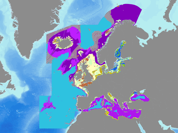
EUSeaMap2 (2016) Broad-Scale Predictive Habitat Map - MSFD Predominant Habitats
Output of the 2016 EUSeaMap broad-scale predictive model, produced by EMODnet Seabed Habitats and aggregated into the predominant habitats of the Marine Strategy Framework Directive.
The extent of the mapped area includes the Mediterranean Sea, Black Sea, Baltic Sea, and areas of the North Eastern Atlantic extending from the Canary Islands in the south to Norway in the North.
The map was produced using a "top-down" modelling approach using classified habitat descriptors to determine a final output habitat.
Habitat descriptors differ per region but include:
Biological zone
Energy class
Oxygen regime
Salinity regime
Seabed Substrate
Riverine input
Habitat descriptors (excepting Substrate) are calculated using underlying physical data and thresholds derived from statistical analyses or expert judgement on known conditions.
The model is produced in Arc Model Builder (10.1). For more information on the modelling process please read the EMODnet Seabed Habitats
The model was created using raster input layers with a cell size of 0.002dd (roughly 250 meters). The model includes the sublittoral zone only; due to the high variability of the littoral zone, a lack of detailed substrate data and the resolution of the model, it is difficult to predict littoral habitats at this scale.
Simple
- Date (Publication)
- 2016-09-30
- Date (Creation)
- 2016-09-30
- Credit
- EMODnet Seabed Habitats
- Status
- completed Completed
- GEMET - INSPIRE themes, version 1.0
-
- Habitats and biotopes
- Marine Strategy Framework Directive
- Predominant habitats
- Thèmes Sextant
-
- /Physical Environment/Physical Habitats
- GEMET - INSPIRE themes, version 1.0
-
- Habitats and biotopes
- DCSMM : Descripteurs
-
- D5: Eutrophication
- D6: Sea-floor Integrity
- Use limitation
- No conditions apply
- Access constraints
- Copyright
- Other constraints
- Please cite EMODnet Seabed Habitats when using these data or products derived from these data
- Denominator
- 250000
- Metadata language
- English
- Topic category
-
- Biota
- Environment
- Oceans
))
- Reference system identifier
- EPSG / WGS 84 (EPSG:4326) / 7.4
- Distribution format
-
-
Web Mapping Service
(
1.1.0
)
-
Web Mapping Service
(
1.1.0
)
- OnLine resource
-
EMODnet Seabed Habitats interactive map
(
WWW:LINK
)
EMODnet Seabed Habitats interactive map
- OnLine resource
-
EMODnet Seabed Habitats downloads page - EUSeaMap preselected
(
WWW:DOWNLOAD
)
EMODnet Seabed Habitats downloads page - EUSeaMap preselected
- OnLine resource
-
EUSMMSFD
(
OGC:WMS-1.1.1-http-get-map
)
EUSeaMap 2016 Broadscale predictive habitat map - classified by MSFD Predominant habitats
- Hierarchy level
- Dataset
- Statement
- An accompanying confidence layer is available for viewing and download from EMODnet Seabed Habitats.
- File identifier
- 5d4696dc-bac4-4dd4-82c5-258700553cb4 XML
- Metadata language
- English
- Character set
- MD_CharacterSetCode_utf8
- Parent identifier
- EUSeaMap2 (2016) Broad-Scale Predictive Habitat Map 2793db6c-4b93-449a-a67b-0abb4533080e
- Hierarchy level
- Dataset
- Date stamp
- 2025-05-15T22:34:05.342525Z
- Metadata standard name
- ISO 19115-3 - SEXTANT
- Metadata standard version
- 1.0
Overviews
Spatial extent
Provided by
