 Catalogue PIGMA
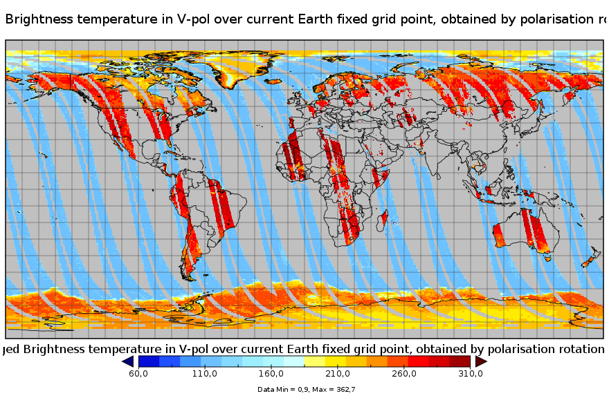
CATDS-PDC L3TB - Global polarised brightness temperature product from SMOS satellite
Simple
- Date (Publication)
- 2024-06-11
- Identifier
- CATDS-PDC_L3TB
- Identifier
- DOI:10.12770/6294e08c-baec-4282-a251-33fee22ec67f
- Credit
- CATDS (CNES, IFREMER, CESBIO)
- Thèmes Sextant
-
- /Imagery/Satellite Imagery
- GEMET - INSPIRE themes, version 1.0
-
- Oceanographic geographical features
- Theme
-
- SMOS
- CATDS
- CPDC
- L3TB
- Brightness Temperature
- Common Product
- ODATIS aggregation parameters and Essential Variable names
-
- Air temperature
- Type de jeux de donnée ODATIS
-
- /Observational data/satellite
- Use limitation
- Creative Commons license to apply : Attribution (BY) : http://creativecommons.org/licenses/?lang=en
- Access constraints
- License
- Use constraints
- License
- Spatial representation type
- grid Grid
- Denominator
- 1
- Metadata language
- English
- Character set
- utf8 UTF8
- Topic category
-
- Geoscientific information
))
- Begin date
- 2010-01-12
- Reference system identifier
- EPSG / WGS 84 / NSIDC EASE-Grid 2.0 Global (EPSG:6933) / 8.6
- Number of dimensions
- 3
- Dimension name
- Column
- Dimension size
- 1388
- Dimension name
- Vertical
- Dimension size
- 584
- Dimension name
- Sample
- Dimension size
- 14
- Cell geometry
- Area
- Transformation parameter availability
- No
- Distribution format
-
-
NetCDF
(
netcdf 3 with 64 bit offset option
)
-
NetCDF
(
netcdf 3 with 64 bit offset option
)
- OnLine resource
-
CYL-RE07-ASC
(
WWW:DOWNLOAD
)
CYL-RE07-ASC - Reprocessed products (01/2010 - 05/2021), cylindrical projection, ascending orbits
- OnLine resource
-
CYL-RE07-DESC
(
WWW:DOWNLOAD
)
CYL-RE07-DESC - Reprocessed products (01/2010 - 05/2021), cylindrical projection, descending orbits
- OnLine resource
-
CYL-OPER-ASC
(
WWW:DOWNLOAD
)
CYL-OPER-ASC - Operational products (06/2021 - now), cylindrical projection, ascending orbits
- OnLine resource
-
CYL-OPER-DESC
(
WWW:DOWNLOAD
)
CYL-OPER-DESC - Operational products (06/2021 - now), cylindrical projection, descending orbits
- OnLine resource
-
POL-OPER-NORTH
(
WWW:DOWNLOAD
)
POL-OPER-NORTH - Operational products (04/2024 - now), polar projection, north hemisphere
- OnLine resource
-
POL-OPER-SOUTH
(
WWW:DOWNLOAD
)
POL-OPER-SOUTH - Operational products (04/2024 - now), polar projection, south hemisphere
- OnLine resource
-
FTP Access
(
WWW:DOWNLOAD
)
FTP Access - All products are also available by ftp : server ftp.ifremer.fr, login ext-catds-cpdc, passwd catds2010, path Common_products/GRIDDED/... (same relative paths as the https links)
- OnLine resource
- SMOS Level 3 Brightness Temperature (TB) Users’manual and useful tips Quality assessment flags ( WWW:LINK )
- OnLine resource
-
POL-RE08-NORTH
(
WWW:DOWNLOAD
)
POL-RE08-NORTH - Reprocessed products (01/2010 - 03/2024), polar projection, north hemisphere
- OnLine resource
-
POL-RE08-SOUTH
(
WWW:DOWNLOAD
)
POL-RE08-SOUTH - Reprocessed products (01/2010 - 03/2024), polar projection, north hemisphere
- OnLine resource
-
CATDS Sipad
(
WWW:LINK
)
CATDS Sipad - Web-based interactive tool which allows subsettings and temporal agregation.
- OnLine resource
-
CATDS Web portal
(
WWW:LINK
)
CATDS Web portal
- OnLine resource
-
Reference
(
WWW:LINK-1.0-http--publication-URL
)
Al Bitar Ahmad, Mialon Arnaud, Kerr Yann H., Cabot Francois, Richaume Philippe, Jacquette Elsa, Quesney Arnaud, Mahmoodi Ali, Tarot Stephane, Parrens Marie, Al-Yaari Amen, Pellarin Thierry, Rodriguez-Fernandez Nemesio, Wigneron Jean-Pierre (2017). The global SMOS Level 3 daily soil moisture and brightness temperature maps. Earth System Science Data, 9(1), 293-315. Publisher's official version : http://doi.org/10.5194/essd-9-293-2017 , Open Access version : http://archimer.ifremer.fr/doc/00388/49941/
- OnLine resource
-
DOI of the dataset
(
DOI
)
DOI of the dataset
- Hierarchy level
- Dataset
- Statement
-
The base products, for all the CATDS-PDC (Centre Aval de Traitement des Données SMOS - Production & Dissemination Center) processing chains, are the SMOS L1B products - https://doi.org/10.57780/SM1-e20cf57 - from ESA (European Space Agency).
The L3TB product includes all brightness temperatures from SMOS satellite acquired that day, at top of atmosphere level, transformed to ground polarisation reference frame, filtered when several acquisitions are available, and binned and averaged into fixed incidence angle classes (including a 40° incidence angle, to ease the comparison with SMAP data). This product is available on each of the EASE2 grid projections (cylindrical and polar).
For the cylindrical projection: Ascending and descending orbits are processed separately, and only in full polarisation. For the polar projections: Each orbit (equator to equator) is processed separately.
For the cylindrical projection: Products from reprocessing RE07 are available for the period 01/2010 - 05/2021. Products from operational (OPER) processing are available since 06/2021.
For the polar projections: Products from reprocessing RE08 are available for the period 01/2010 - 03/2024. Products from operational (OPER) processing are available since 04/2024.
Reprocessed products and operational products are derived using the same algorithm and configuration, hence ensuring the temporal continuity.
In this product, the brightness temperature values potentially contaminated by RFI or by the sun are not removed from the data. Instead, 2 counter fields (Nb_RFI_Flags and NB_SUN_Flags) are present, in order to count the number of views identified as contaminated. Therefore a low counter value means a low probability of contamination, and a high counter value means a high probability of contamination.
File naming :
SM_clas_MIR_CDF3Tx_startdate_enddate_vvv_ccc_7
- clas : File class (OPER : operational mode, REXX : reprocessing xx)
- x : A for ascending orbit, D for descending orbit, N for north pole, S for south pole
- startdate : sensing start date/time of the data (format yyyymmddThhmiss)
- enddate : sensing end date/time of the data (format yyyymmddThhmiss)
- vvv : version number of the processor generating the product
- ccc : file counter
File format :
In each archive file (.tgz extension), there are two files
- A Header file (.HDR), which is a text file, in XML Earth Explorer Header format
- A Data file (.DBL.nc), which is a netcdf file, format variant 2 (netcdf 3 with 64 bits offset option)
Reference :
Al Bitar Ahmad, Mialon Arnaud, Kerr Yann H., Cabot Francois, Richaume Philippe, Jacquette Elsa, Quesney Arnaud, Mahmoodi Ali, Tarot Stephane, Parrens Marie, Al-Yaari Amen, Pellarin Thierry, Rodriguez-Fernandez Nemesio, Wigneron Jean-Pierre (2017). The global SMOS Level 3 daily soil moisture and brightness temperature maps. Earth System Science Data, 9(1), 293-315. Publisher's official version : http://doi.org/10.5194/essd-9-293-2017 , Open Access version : http://archimer.ifremer.fr/doc/00388/49941/
- File identifier
- 6294e08c-baec-4282-a251-33fee22ec67f XML
- Metadata language
- English
- Character set
- UTF8
- Hierarchy level
- Dataset
- Date stamp
- 2025-11-01T14:04:57.884159Z
- Metadata standard name
- ISO 19115-3 - SEXTANT
- Metadata standard version
- 1.0
Overviews
Spatial extent
Provided by
