 Catalogue PIGMA
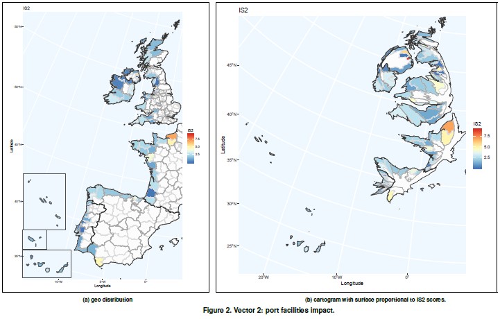
MOSES project - WP6 - Vector 2 - Port facilities impact
It contemplates the assessment of vulnerability due to passengers and goods transportation and cov- ers indicators related to sustainability awareness (energy efficiency, land use, etc.).
Shipping has an environmental impact both in ports, as well as in the immediate vicinity of the ports. This vector tries to capture the impact of the port activity on vulnerability. Vector 2 indicators have been obtained from Eurostat and EcoPorts, a environmental initiative of the European port sector fully integrated into the European Sea Ports Organisation (ESPO) since 2011.
Simple
- Date (Publication)
- 2020-11-12
- Identifier
- MOSES_WP6_VECTOR2
- Credit
- MOSES project
- Thèmes Sextant
-
- /Human Activities/Marine Structures/Ports
- GEMET - INSPIRE themes, version 1.0
-
- Area management/restriction/regulation zones and reporting units
- Use limitation
- CC-BY (Creative Commons - Attribution)
- Access constraints
- Other restrictions
- Use constraints
- Copyright
- Spatial representation type
- vector Vector
- Metadata language
- English
- Character set
- utf8 UTF8
- Topic category
-
- Oceans
))
- Reference system identifier
- EPSG / WGS 84 (EPSG:4326) / 7.4
- Distribution format
-
-
(
)
-
(
)
- OnLine resource
- MOSES WP6 Data gathering and compilation of indicators ( WWW:LINK )
- OnLine resource
- MOSES WP6 Data processing and construction of synthetic index ( WWW:LINK )
- OnLine resource
- MOSES WP6 Analysis and dissemination of results ( WWW:LINK )
- OnLine resource
-
MOSES_WP6_VECTOR2
(
OGC:WMS
)
Vector 2 : Port facilities impact
- OnLine resource
- MOSES_WP6_vulnerability ( WWW:DOWNLOAD )
- Hierarchy level
- Dataset
Domain consistency
Conformance result
- Date (Publication)
- 2010-12-08
- Explanation
- See the referenced specification
- Statement
-
1. List of ports (Eurostat).
https://ec.europa.eu/eurostat/documents/345175/6807882/
Ttypologies+and+local+information+corresponding+to+NUTS3. xls
2. EcoPorts: https://www.ecoports.com/network
3. GISCO Ports 2013 dataset (Eurostat).
https://ec.europa.eu/eurostat/cache/GISCO/geodatafiles/ PORT_2013_SH.zip
4. Gross weight of goods handled in all ports by direction - annual data (Eurostat).
http://appsso.eurostat.ec.europa.eu/nui/show.do?dataset= mar_go_aa&lang=en
5. Passengers embarked and disembarked in all ports by direction - annual data (Eurostat).
http://appsso.eurostat.ec.europa.eu/nui/show.do?dataset= mar_pa_aa&lang=en.
- File identifier
- 6321ff38-ec44-4f0a-9992-151bbc664c97 XML
- Metadata language
- English
- Character set
- UTF8
- Hierarchy level
- Dataset
- Date stamp
- 2025-05-15T22:38:55.06176Z
- Metadata standard name
- ISO 19115-3 - SEXTANT
- Metadata standard version
- 1.0
Overviews
Spatial extent
Provided by
