 Catalogue PIGMA
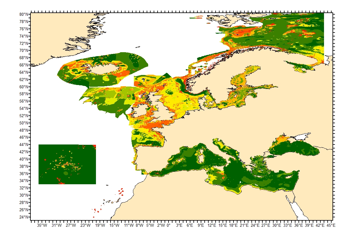
Modelled seabed sediment average grain size in the European North-East Atlantic and Mediterranean waters
Simple
- Date (Creation)
- 2024-04-15
- Date (Publication)
- 2024-04-15
- Credit
- Ifremer
- Thèmes Sextant
-
- /Physical Environment/Sedimentology Geology
- GEMET - INSPIRE themes, version 1.0
-
- Geology
- DCSMM : Descripteurs
-
- D6: Sea-floor Integrity
- Sous-regions marines
-
- /Metropolitan France
- Thématiques - SIMM
-
- /Environmental Status/Geology
- /Environmental Status/Habitats
- Use limitation
- CC-BY (Creative Commons - Attribution)
- Access constraints
- Other restrictions
- Use constraints
- Copyright
- Other constraints
- We do our best to ensure that the data is complete, accurate and useful. However, because the processing required to generate the data is complex, we cannot be liable for omissions or inaccuracies. The data and any related materials contained therein are provided “as is”, without warranty of any kind, either expressed or implied, including but not limited to, fitness for a particular purpose, non-interference, system integration, or non-infringement. The entire risk of use of the data shall be with the user.
- Spatial representation type
- vector Vector
- Metadata language
- English
- Character set
- utf8 UTF8
- Topic category
-
- Oceans
- Environment
))
- Reference system identifier
- EPSG / WGS 84 (EPSG:4326) / 8.6
- Geometric object type
- Surface
- Distribution format
-
-
(
)
-
(
)
- OnLine resource
- iso 16665 ( WWW:LINK )
- OnLine resource
- EUSeaMap.A European broad-scale seabed habitat map ( WWW:LINK )
- OnLine resource
- EUSeaMap, EUNIS full detail classification ( WWW:LINK )
- Protocol
- COPYFILE
- Name
- Average_grain_size
- OnLine resource
- EUSeaMap 2023, A European broad-scale seabed habitat map, Technical Report ( WWW:LINK-1.0-http--publication-URL )
- OnLine resource
- EUSeaMap_2023 original layer download ( WWW:LINK )
- OnLine resource
- Digital Object Identifier (DOI) ( DOI )
- Hierarchy level
- Dataset
Domain consistency
Conformance result
- Date (Publication)
- 2010-12-08
- Explanation
- See the referenced specification
- Pass
- No
- Description
-
Sediment average grain size was generated from sediment categories.
EUSeaMap sediment map of the European waters was used to obtain sediment distribution, grain size range (mm) per sediment group and % fraction of each main sediment group (Rock, coarse sediment, coarse and mixed sediment, mixed sediment, sand, muddy sand, sandy mud, fine mud or sandy mud, fine mud). Upper and lower boundaries for rock, pebble and clay size were derived from iso 16665 description. Fraction per category were derived from Folk (1954) sediment classification modified after EUSeaMap European broad-scale seabed habitat map description of categories.
Folk, R. L., 1954. The distinction between grain size and mineral composition in sedimentary rock nomenclature, Jour. Geology 62, 344–359.
- Description
-
Römkens et al. (1997) equation enabling the estimation of average grain size from sediment typologie and fraction was applied:
X = exp[ 0.01 * SUM( fi * ln( mi ) ) ]
where X :average grain size (mm) ; mi : estimated average grain size of ith sediment category (mm) and ; fi : corresponding fraction of mi (%).
Römkens, M. J. M., Young, R. A., Poesen, J. W. A., McCool, D. K., El-Swaify, S. A., & Bradford, J. M., 1997. Soil erodibility factor (K). Renard KG et al., Predicting soil erosion by water: a guide to conservation planning with the Revised Universal Soil Loss Equation (RUSLE). USDA Agriculture Handbook, (703), 65-99.
- Description
-
Sediment categories were recoded with the computed average grain size and the value was attributed to the corresponding polygons.
The categories - grain size correspondance are:
"fine mud" = 0.031525 mm, "sandy mud" = 0.09243549 mm, "Fine mud or sandy mud or muddy sand" = 0.17008322 mm, "Sandy mud or muddy sand" = 0.23936233056056 mm, "muddy sand" = 0.386289173 mm, "sand" = 0.94424275 mm, "mixed sediment" = 1.67029356 mm, "coarse & mixed sediment" = 6.34059641 mm, "coarse sediment" = 11.01089925 mm, "Rock or other hard substrata" = 2032 mm
- Description
- Polygones corresponding to undescribed sediment types, biogenic or seagrass habitats were removed from the layer as their average grain size were unknown.
- File identifier
- 79050557-6f8a-48cc-9e60-4112cae9fd18 XML
- Metadata language
- English
- Character set
- UTF8
- Hierarchy level
- Dataset
- Date stamp
- 2025-05-15T22:57:25.68765Z
- Metadata standard name
- ISO 19115-3 - SEXTANT
- Metadata standard version
- 1.0
Overviews
Spatial extent
Provided by
