 Catalogue PIGMA
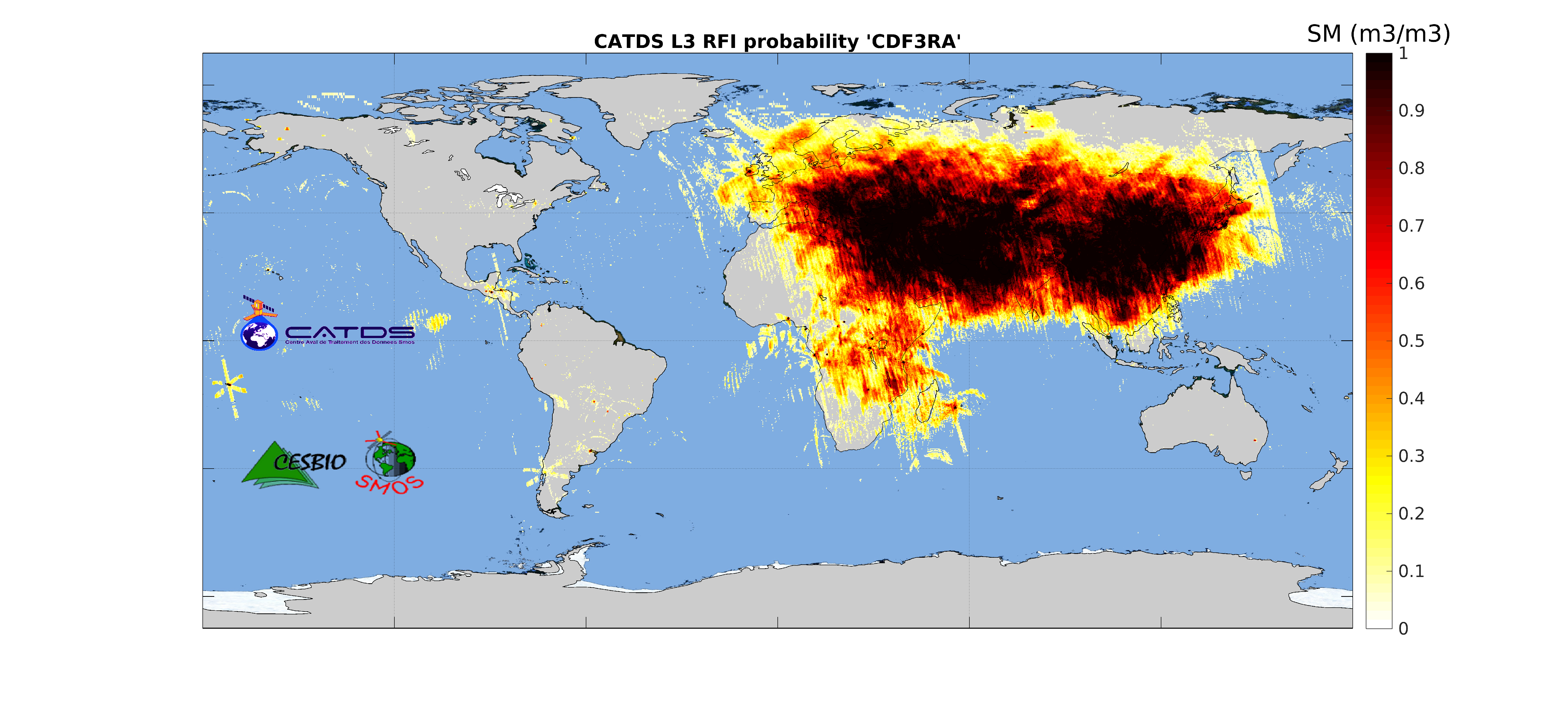
CATDS-PDC L3RFI - Monthly multi-angular RFI probability product from SMOS satellite
This product is radio frequency interference (RFI) probability for each angle bin computed daily and based on a monthly moving window average. Ascending and descending orbits are processed separately, and only in full polarization.
** This product is no longer available, see below **
Simple
- Date (Publication)
- 2016-02-25
- Identifier
- CATDS-PDC_L3RFI
- Identifier
- DOI:10.12770/801f394b-b33a-4a8f-b491-0aa94d3198c2
- Credit
- CATDS (CNES, IFREMER, CESBIO)
- Thèmes Sextant
-
- /Imagery/Satellite Imagery
- GEMET - INSPIRE themes, version 1.0
-
- Orthoimagery
- Theme
-
- SMOS
- CATDS
- CPDC
- L3RFI
- Radio Frequency Interference
- Common Product
- Use limitation
- Creative Commons license to apply : Attribution (BY) : http://creativecommons.org/licenses/?lang=en
- Access constraints
- License
- Use constraints
- License
- Spatial representation type
- grid Grid
- Denominator
- 1
- Metadata language
- English
- Character set
- utf8 UTF8
- Topic category
-
- Geoscientific information
))
- Begin date
- 2010-01-12
- Reference system identifier
- EPSG / WGS 84 / NSIDC EASE-Grid 2.0 Global (EPSG:6933) / 8.6
- Number of dimensions
- 3
- Dimension name
- Column
- Dimension size
- 1388
- Dimension name
- Vertical
- Dimension size
- 584
- Dimension name
- Sample
- Dimension size
- 14
- Cell geometry
- Area
- Transformation parameter availability
- No
- Distribution format
-
-
NetCDF
(
netcdf 3 with 64 bit offset option
)
-
NetCDF
(
netcdf 3 with 64 bit offset option
)
- OnLine resource
-
CATDS Sipad
(
WWW:LINK
)
CATDS Sipad - Web-based interactive tool which allows subsettings and temporal agregation.
- OnLine resource
-
CATDS Web portal
(
WWW:LINK
)
CATDS Web portal
- OnLine resource
-
DOI of the dataset
(
DOI
)
DOI of the dataset
- Hierarchy level
- Dataset
- Statement
-
This product is no longer available. Instead, we recommend to use the updated version of the product CATDS-PDC L3TB - Global polarised brightness temperature product from SMOS satellite (https://doi.org/10.12770/6294e08c-baec-4282-a251-33fee22ec67f), which now contains a probability of RFI contamination field.
The base products, for all the CATDS-PDC (Centre Aval de Traitement des Données SMOS - Production & Dissemination Center) processing chains, are the SMOS L1B products from ESA (European Space Agency).
The L3RFI product is radio frequency interference (RFI) probability for each angle bin computed daily and based on a monthly moving window average. Ascending and descending orbits are processed separately, and only in full polarisation.
Products from reprocessing RE04 are available for the period 01/2010 - 04/2015. Products from operational (OPER) processing are available since 05/2015. Reprocessed products and operational products are derived using the same algorithm and configuration, hence ensuring the temporal continuity.
File naming :
SM_clas_MIR_CDF3Rx_startdate_enddate_vvv_ccc_7
- clas : File class (OPER : operational mode, REXX : reprocessing xx)
- x : A for ascending orbit, D for descending orbit
- startdate : sensing start date/time of the data (format yyyymmddThhmiss)
- enddate : sensing end date/time of the data (format yyyymmddThhmiss)
- vvv : version number of the processor generating the product
- ccc : file counter
File format :
In each archive file (.tgz extension), there are two files
- A Header file (.HDR), which is a text file, in XML Earth Explorer Header format
- A Data file (.DBL.nc), which is a netcdf file, format variant 2 (netcdf 3 with 64 bits offset option)
References :
Daganzo-Eusebio, E., R. Oliva, Y. H. Kerr, S. Nieto, P. Richaume, and S. M. Mecklenburg. 2013. 'Smos radiometer in the 400-1427-mhz passive band: Impact of the rfi environment and approach to its mitigation and cancellation', Ieee Transactions on Geoscience and Remote Sensing, 51: 4999-5007.-: 10.1109/tgrs.2013.2259179
Soldo, Yan, Ali Khazaal, Ewa Slominska, Francois Cabot, Remy Fieuzal, Yann H. Kerr, and Ieee. 2013. 'Monitoring of rfi localizations for the smos mission: Seasonal variations and systematic errors.' in, 2013 ieee international geoscience and remote sensing symposium.2153-6996 978-1-4799-1114-1
Soldo, Y., A. Khazaal, F. Cabot, P. Richaume, E. Anterrieu, and Y. H. Kerr. 2014. 'Mitigation of rfis for smos: A distributed approach', Ieee Transactions on Geoscience and Remote Sensing, 52: 7470-7479.-: 10.1109/tgrs.2014.2312988
Soldo, Y., F. Cabot, A. Khazaal, M. Miernecki, E. Slominska, R. Fieuzal, and Y. H. Kerr. 2015. 'Localization of rfi sources for the smos mission: A means for assessing smos pointing performances', Ieee Journal of Selected Topics in Applied Earth Observations and Remote Sensing, 8: 617-627.-: 10.1109/jstars.2014.2336988
Anterrieu, E., A. Khazaal, F. Cabot, and Y. Kerr. 2016. '- geolocation of rfi sources with sub-kilometric accuracy from smos interferometric data', RSE - 180: - 84.-:
- File identifier
- 801f394b-b33a-4a8f-b491-0aa94d3198c2 XML
- Metadata language
- English
- Character set
- UTF8
- Hierarchy level
- Dataset
- Date stamp
- 2025-05-15T23:03:18.437865Z
- Metadata standard name
- ISO 19115-3 - SEXTANT
- Metadata standard version
- 1.0
Overviews
Spatial extent
Provided by
