 Catalogue PIGMA
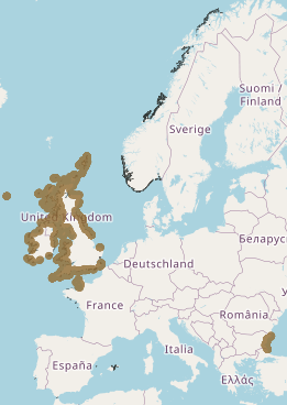
Macroalgal canopy cover (Essential Ocean Variable) in Europe used in Mission Atlantic for the case study Celtic Sea - points (2021) and polygons (2019)
This layer shows the current known extent and distribution of macroalgal canopy in European waters, collated by EMODnet Seabed Habitats. The polygons portion was last updated in 2019. The points were added in Sept 2021. The purpose was to produce a data product that would provide the best compilation of evidence for the essential ocean variable (EOV) known as Macroalgal canopy cover and composition (sub-variable: Areal extent), as defined by the Global Ocean Observing System (GOOS). Kelp and fucoid brown algae are the dominant species that comprise macroalgal forests. This data product should be considered a work in progress and is not an official product.
Simple
- Date (Revision)
- 2021-09-23
- Identifier
- 8c451b52-4ebd-4f6e-b17d-b881db25ed4c
- Credit
- European Marine Observation and Data Network
- Thèmes Sextant
-
- /Biological Environment/Habitats
- GEMET - INSPIRE themes, version 1.0
-
- Habitats and biotopes
- Mission Atlantic - Resources
-
- Data
- Mission Atlantic - Case Studies
-
- Celtic Seas
- Mission Atlantic - BODC Parameters
-
- /Biological oceanography/Macroalgae and seagrass
- /Environment/Habitat
- Mission Atlantic - Data type (DMP)
-
- Biological data
- Spatial data products
- Mission Atlantic - Work Package
-
- WP4 Benthic Mapping
- Use limitation
- CC-BY (Creative Commons - Attribution)
- Spatial representation type
- vector Vector
- Metadata language
- English
- Character set
- utf8 UTF8
- Topic category
-
- Oceans
N
S
E
W
))
- Unique resource identifier
- EPSG:4258
- Distribution format
-
-
ESRI Shapefile
(
1.0
)
-
ESRI Shapefile
(
1.0
)
- OnLine resource
- EMODnet map viewer (Seabed Habitats) ( WWW:LINK )
- OnLine resource
- EMODnet catalogue (Seabed Habitat) ( WWW:LINK )
- Hierarchy level
- Dataset
- Statement
- This data product is a work in progress. The polygon file was produced by the 2017-2019 EMODnet Seabed Habitats consortium and the method is described in O'Keefe and Lillis (2019). The point file was produced by the 2019-2021 EMODnet Seabed Habitats consortium and the method is described in Lillis (2021).
- File identifier
- 8c451b52-4ebd-4f6e-b17d-b881db25ed4c XML
- Metadata language
- English
- Character set
- UTF8
- Hierarchy level
- Dataset
- Date stamp
- 2025-05-15T23:14:54.50061Z
- Metadata standard name
- ISO 19115-3 - SEXTANT
- Metadata standard version
- 1.0
Point of contact
Ifremer
-
Sextant
ZI Pointe du Diable
,
Plouzane
,
Brittany
,
29280
,
France
https://sextant.ifremer.fr/eng
Overviews
Spatial extent
N
S
E
W
Provided by

Associated resources
Not available