 Catalogue PIGMA
Marine Reporting Units used in Marine Strategy Framework Directive (MSFD) 2012-2018 reporting cycle - version 1.0, Feb. 2020
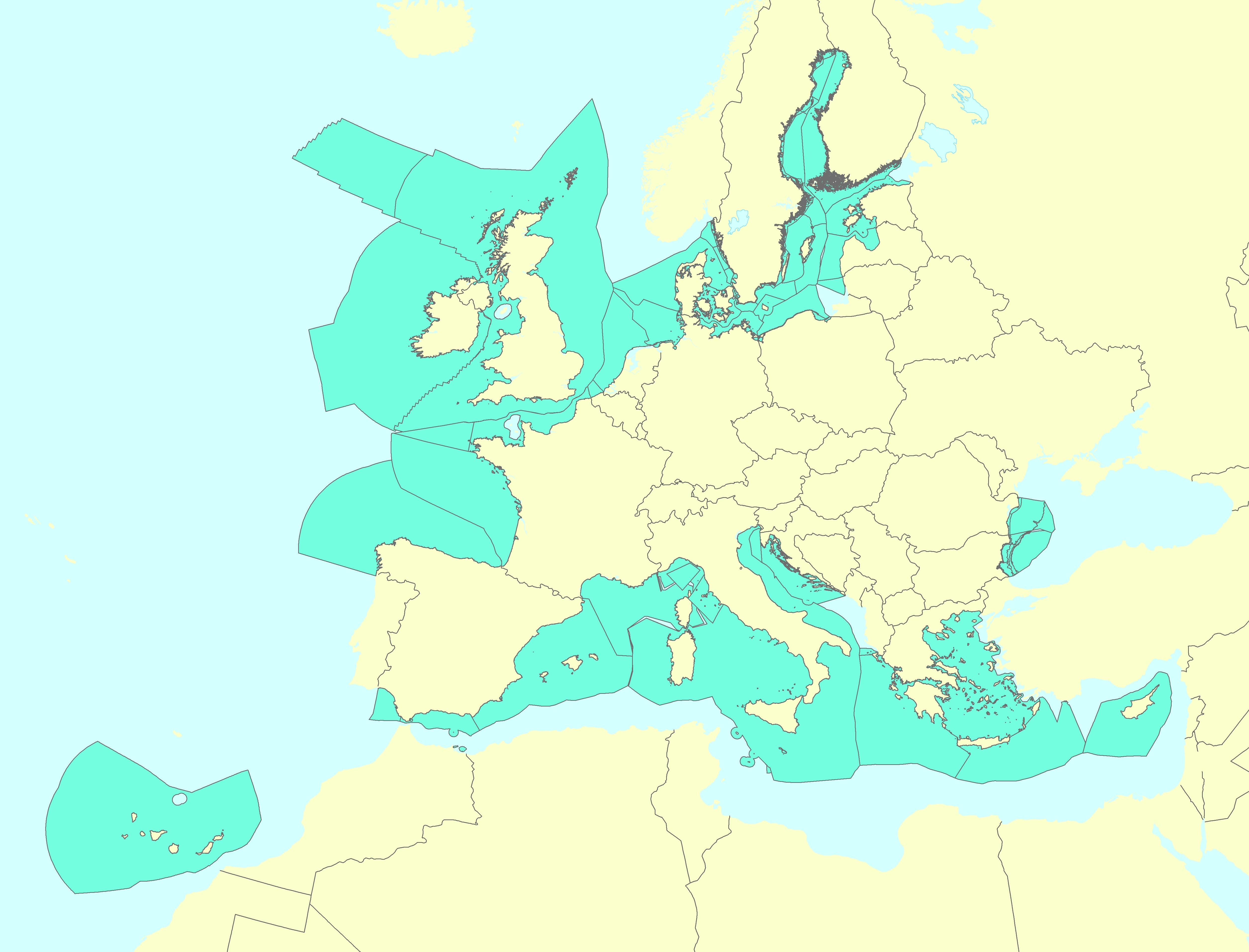
The Marine Reporting Units (MRUs) are used within the reporting obligations of the Marine Strategy Framework Directive (MSFD) in order to link the implementation of the different articles to specific marine areas. The MRUs can be of varying sizes, according to the appropriate scale for the different reports (e.g. region, sub-region, regional or sub-regional subdivision, Member State marine waters, WFD coastal waters, etc.), as indicated in the Good Environmental Status 2017 Decision.
The present data set is the first public version released of the MRUs used during the first cycle of implementation of the MSFD (2012-2018) in all the reporting exercises (2012 reporting of Articles 8, 9 and 10; 2014 reporting of Article 11; and 2016 reporting of Articles 13 & 14). The data set is distributed in SHP and in INSPIRE-compliant GML format.
Simple
- Date (Creation)
- 2019-12-27
- Date (Publication)
- 2020-02-28
- Edition
- 01.00
- Identifier
- eea_v_4258_100_k_mru-msfd2012_i_2012-2018_v01_r00
- Status
- superseded superseded
- Maintenance and update frequency
- As needed
- Keywords
-
- Keywords
-
- GEMET
-
- Marine Strategy Framework Directive
- marine environment
- sea
- Continents, countries, sea regions of the world.
-
- Mediterranean Sea
- Black Sea
- Baltic Sea
- Northeast Atlantic Ocean (40W)
- Spatial scope
-
- European
- INSPIRE priority data set
-
- Directive 2008/56/EC
- Marine reporting units (Marine Strategy Framework Directive)
- EEA topics
-
- Seas and coasts
- Sous-regions marines
-
- /Métropole
- /Métropole/Manche mer du Nord
- /Métropole/Mers Celtiques
- /Métropole/Golfe de Gascogne
- /Métropole/Méditerranée occidentale
- Thématiques - SIMM
-
- /Actions concrètes
- Thématiques - SIMM
-
- /Activités et Usages/Analyse économique et sociale
- Type de jeux de donnée - ODATIS
-
- /Données administratives
- Type de jeux de donnée - ODATIS
-
- /Données dérivées/Références statistiques
- Cadre Réglementaire - SIMM
-
- Directive Cadre Stratégie pour le Milieu Marin (DCSMM)
- Access constraints
- Other restrictions
- Other constraints
- no limitations to public access
- Use constraints
- Other restrictions
- Other constraints
- License CC-BY 4.0 (https://creativecommons.org/licenses/by/4.0/). Copyright holder: European Environment Agency (EEA).
- Aggregate Datasetindentifier
- 8ee108bc-6b08-48ac-bc5a-45a5cd6b5a6c
- Association Type
- Cross reference
- Spatial representation type
- vector Vector
- Denominator
- 100000
- Metadata language
- English
- Topic category
-
- Environment
- Oceans
))
- Begin date
- 2012-10-16
- End date
- 2018-10-15
- Unique resource identifier
- EPSG:4258
- Distribution format
-
-
SHP
(
)
-
GML
(
3.2.1
)
- Specification
- D2.8.III.11 INSPIRE Data Specification on Area Management/Restriction/Regulation Zones and Reporting Units – Technical Guidelines
-
SHP
(
)
OnLine resource
- OnLine resource
- Direct download (Eionet authentication) ( WWW:URL )
- OnLine resource
- INSPIRE-compliant Atom Service ( WWW:DOWNLOAD-1.0-http--download )
- Hierarchy level
- Dataset
Domain consistency
Conformance result
- Date (Publication)
- 2010-12-08
- Explanation
- See the referenced specification
- Pass
- Yes
- Statement
- The present MRUs data set is a compilation of the layers submitted by Member States (in SHP format) to the European Commission during the reporting exercises of the first cycle of implementation of the MSFD. The reporting exercises were due by 15/10/2012 (Articles 8, 9 and 10), by 15/10/2014 (Article 11) and by 31/03/2016 (Articles 13 & 14). The pan-European data set has been created in GML following the INSPIRE 'Area management / restriction / regulation zones and reporting units' theme data specifications (available at https://inspire.ec.europa.eu/id/document/tg/am ). For the development of the GML, a number of fields have been included and filled in with the criteria described in the document 'Development of a pan-European data set of Marine Reporting Units' (file "Documentation_MRUs_v1-1.pdf" provided with the data set). The data set has also been published as an INSPIRE-compliant ATOM web service. A shapefile format version has also been produced.
- File identifier
- 99869345-d8b0-4933-a9d0-3c9e08055c4a XML
- Metadata language
- English
- Character set
- UTF8
- Hierarchy level
- Dataset
- Date stamp
- 2025-10-09T11:05:22.249392Z
- Metadata standard name
- ISO 19115/19139
- Metadata standard version
- 1.0
Overviews
Spatial extent
Provided by
