 Catalogue PIGMA
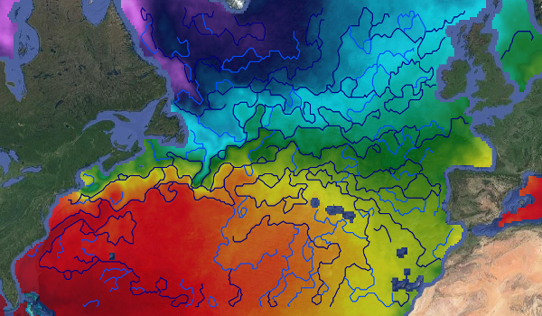
WOC Fronts Derived from Remote Sensing Microwave SST L4 over North Atlantic Region
This dataset provides detections of fronts derived from low resolution optimally interpolated remote sensing microwave SST L4 from REMSS over North Atlantic region.
The data are available through HTTP and FTP; access to the data is free and open. In order to be informed about changes and to help us keep track of data usage, we encourage users to register at: https://forms.ifremer.fr/lops-siam/access-to-esa-world-ocean-circulation-project-data/
This dataset was generated by OceanDataLab and is distributed by Ifremer / CERSAT in the frame of the World Ocean Circulation (WOC) project funded by the European Space Agency (ESA).
Simple
- Date (Creation)
- 2022-05-03
- Date (Publication)
- 2022-05-03
- Identifier
- WOC-L4-FRONTS-NATL_1D_025 / v2.0
- Status
- completed Completed
- Cersat - Parameter
-
- Ocean currents
- Cersat - Project
-
- WOC
- Cersat - Latency
-
- Historical
- Cersat - GCMD parameter
-
- /Ocean Circulation/Fronts
- Variables ODATIS
-
- /Physical Oceanography/Currents
- Use limitation
- None
- Access constraints
- unrestricted
- Use constraints
- Other restrictions
- Other constraints
- CC-BY (Creative Commons - Attribution)
- Other constraints
- OceanDataLab, 2022. Fronts Derived from Remote Sensing Microwave SST L4 over North Atlantic Region from ESA WOC project. Ver. 2.0. Obtained from CERSAT / Ifremer, Plouzane, France. Dataset accessed [YYYY-MM-DD].
- Spatial representation type
- grid Grid
- Distance
- 0.25 deg
- Topic category
-
- Oceans
))
- Geographic identifier
- North Atlantic
- Begin date
- 2010-01-01
- End date
- 2021-12-31
- Reference system identifier
- http://www.opengis.net/def/crs/EPSG/0/4326
- Distribution format
-
-
JSON
(
)
-
JSON
(
)
- OnLine resource
-
Ifremer HTTPS server
(
WWW:LINK
)
HTTPS
- OnLine resource
-
User guide
(
WWW:LINK
)
Product User Manual
- OnLine resource
-
Processing and validation
(
WWW:LINK
)
Algorithm Theoretical Baseline Document
- OnLine resource
- Digital Object Identifier (DOI) ( DOI )
- Hierarchy level
- Dataset
- Attribute description
- snapshot
- Processing level code
- L4 /
- File identifier
- 9e7718f5-81a4-41c4-880d-29737dd90270 XML
- Metadata language
- English
- Character set
- UTF8
- Hierarchy level
- Dataset
- Date stamp
- 2025-12-01T09:19:52.906174Z
- Metadata standard name
- ISO 19115-3:2018 - Remote Sensing
Overviews
Spatial extent
Provided by
