 Catalogue PIGMA
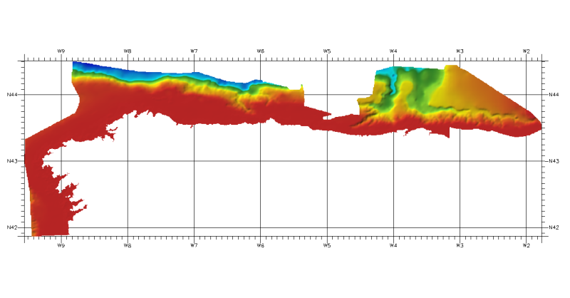
353_291701 - Cantabrian Sea Spain
Simple
- Alternate title
- 291701
- Date (Creation)
- 2017-09-19T15:00:00
- Date (Revision)
- 2017-11-29T11:40:00
- Identifier
- 291701
- Keywords
-
- Project name
-
- EMODnet HRSM
- SeaDataNet device categories
-
- single-beam echosounders
- multi-beam echosounders
- SeaDataNet device categories
-
- Global Navigation Satellite System receivers
- Parameter Discovery Vocabulary (P02)
-
- Bathymetry and Elevation
- GEMET - INSPIRE themes, version 1.0
-
- Hydrography
- Access constraints
- Other restrictions
- Use constraints
- Other restrictions
- Other constraints
- Contact ideo@ieo.es
- Use limitation
- Not for navigation
- Spatial representation type
- Grid
- Denominator
- 100000
- Metadata language
- English
- Character set
- UTF8
- Topic category
-
- Oceans
- Begin date
- 1985-01-15T12:00:00
- End date
- 2017-11-29T12:00:00
))
- Geographic identifier
- Bay of Biscay
- Reference system identifier
- EPSG / WGS 84 (EPSG:4326) / 7.4
- Number of dimensions
- 3
- Dimension name
- Column
- Dimension size
- 1966
- Dimension name
- Row
- Dimension size
- 633
- Dimension name
- Time
- Dimension size
- 1
- Cell geometry
- Point
- Transformation parameter availability
- No
- Checkpoint Availability
- No
- Point in Pixel
-
- Center
- Distribution format
-
-
GeoTIFF
(
1.0
)
- Specification
- Version number to be confirmed
-
GeoTIFF
(
1.0
)
- OnLine resource
-
Web site of the Instituto Espanol de Oceanografia (IEO)
(
WWW:LINK
)
Contact ideo@ieo.es
- Hierarchy level
- Dataset
Vertical extent
- Minimum value
- 0
- Maximum value
- 5544
Vertical CS
Vertical datum
- Statement
- no information
- Hierarchy level
- Feature
- Dataset
- accuracy
Gridded data positional accuracy
- Name of measure
- horizontal accuracy
- Measure identification
- horizontal accuracy of coordinate
- Measure description
- Depends on the sources of data, could be LORAN, DECCA, GPS or DGPS.
- Evaluation method description
- Rough estimate from accuracies of data sources and of positioning systems of the surveys.
Quantitative attribute accuracy
- Name of measure
- depth
- Measure identification
- depth accuracy
- Measure description
- SBES Low Frequency, SDB (similar than 2+5%d) and MBES low frequency (lower than 100kHz) (similar than 1+2%d).
- Evaluation method description
- Comparison together with information on the source data.
Quantitative result
- Value
- not defined
Conformance result
- Date
- Pass
- No
- Hierarchy level
- Software
- Description
- ARcGIS, GLOBE.
- Other
- software
- Hierarchy level
- Property type
- Description
- parameters of data processing
- Attributes
- Statement
-
Description of data processing :
The information was processed with ARCGIS software to create a DTM at a resolution of 100 meters x 100 meters. The IEO got this information in vectorial format as isobaths with different equidistance and points with depth, from coast line or 0 meters to 5216,74 meters, according to depth. From this isobaths using the TOPOGRID (command for interpolation a DTM from isobaths). Later, using GLOBE software, a DTM in angular coordinates at a resolution of 1/16 arc-minute of latitude and longitude (approximately 100 meters) was made.
- Description
-
Description of processed data sources :
Depth data have been obtained from isobaths and depth points from several sources. The data providers have been Spanish Institute of Oceanography, General Secretary of the Sea (MAPAMA), IGME, Coast General Direction (MAPAMA) and Nautical Charts of IHM in Spain.
- Hierarchy level
- Dataset
Absolute external positional accuracy
- Name of measure
- emodnet-bathymetry.QI.Horizontal
- Value
- 1 - Between 500m and 50m
Absolute external positional accuracy
- Name of measure
- emodnet-bathymetry.QI.Vertical
- Value
- -1 - Multisources
Domain consistency
- Name of measure
- emodnet-bathymetry.QI.Purpose
- Value
- 2 - Bathymetric/morphologic survey
- File identifier
- SDN_CPRD_353_291701 XML
- Metadata language
- English
- Character set
- UTF8
- Hierarchy level name
- Composite Product Record
- Date stamp
- 2018-03-20T13:47:29
- Metadata standard name
- ISO 19115:2003/19139 - EMODNET - BATHYMETRY
- Metadata standard version
- 1.0
Overviews
Spatial extent
Provided by
