 Catalogue PIGMA
CATDS-PDC L4OS SMOS-OI - Weekly optimal interpolation salinity field product from SMOS satellite and ISAS
This product contains weekly salinity field, based on SMOS satellite data, and ISAS (In-Situ Analysis System).
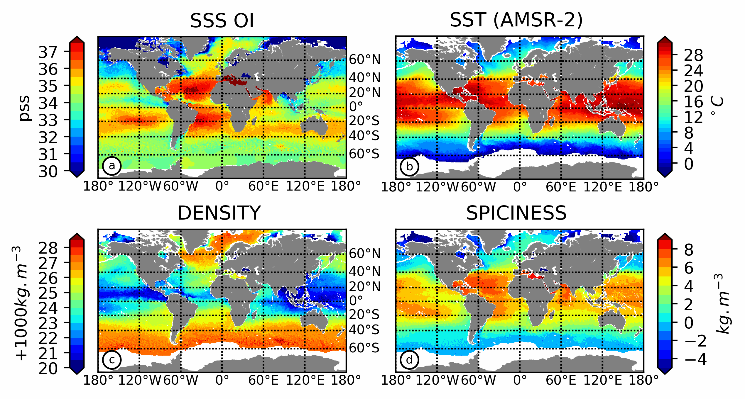
The L4OS SMOS-OI product contains global Level 4 analyses of the of the Sea Surface Salinity (SSS), Sea Surface Density (SSD) and Sea Surface Spiciness (SSSp), along with Sea Surface Absolute Salinity (SSA), Conservative Temperature (SCT), surface thermal expansion coefficient (alpha) and haline contraction coefficient (beta). The SSS product is obtained using an optimal interpolation (OI) algorithm, that combines ISAS in situ SSS OI analyses and Soil Moisture Ocean Salinity (SMOS) satellite image to reduce large scale and temporally varying bias. The SSS L4 product outcome is then combined with satellite SST products to compute thermodynamic sea water parameters using TEOS-10 (Kolodziejczyk et al., 2021).
Products from reprocessing RE07 are available for the period 01/2011 - 05/2021. Products from operational (OPER) processing are available since 06/2021. Reprocessed products and operational products are derived using the same algorithm and configuration, hence ensuring the temporal continuity.
The base products, for all the CATDS-PDC (Centre Aval de Traitement des Données SMOS - Production & Dissemination Center) processing chains, are the SMOS L1B products from ESA (European Space Agency).
From these, brightness temperatures at various incidence angles are reconstructed. The Sea Surface Salinity (SSS) are retrieved from multi-angular brightness temperatures through a maximum likehood Bayesian approach in which measured Tb and Tb simulated using a forward direct model are compared (see Zine et al. 2008 for a general description of the retrieval method, and pro_con table for a summary of the similarities/differences with respect to ESA level 2 ocean salinity processing).
Simple
- Date (Publication)
- 2022-09-19
- Identifier
- CATDS-PDC_L4OS_OI / 344
- Credit
- CATDS (CNES, IFREMER, LOPS)
- Status
- onGoing On going
- Centre de données ODATIS
-
- CDS-SAT-CERSAT
- Theme
-
- SMOS
- CATDS
- CPDC
- L4OS
- Ocean Salinity
- Ocean Product
- OI
- ISAS
- Variables ODATIS
-
- /Physical Oceanography/Salinity
- Access constraints
- OtherRestrictions
- Use constraints
- Product developed by Ifremer/CERSAT and funded in the frame of GMES MyOcean project. Authors : Emmanuelle Autret (eautret@ifremer.fr), Jean-François Piollé (jfpiolle@ifremer.fr)
- Other constraints
- CC-BY (Creative Commons - Attribution)
- Other constraints
-
CATDS-PDC L4OS SMOS-OI - Weekly optimal interpolation salinity field product from SMOS satellite and ISAS.
CATDS (CNES, IFREMER, LOCEAN, ACRI)
https://doi.org/10.12770/639a918e-0711-4eff-965d-15a728acb27d
When using this dataset in a publication, also cite the related work(s) with:
Kolodziejczyk Nicolas, Hamon Michel, Boutin Jacqueline, Vergely Jean-Luc, Reverdin Gilles, Supply Alexandre, Reul Nicolas (2021). Objective analysis of SMOS and SMAP Sea Surface Salinity to reduce large scale and time dependent biases from low to high latitudes. Journal Of Atmospheric And Oceanic Technology, 38(3), 405-421. Publisher's official version : https://doi.org/10.1175/JTECH-D-20-0093.1 , Open Access version : https://archimer.ifremer.fr/doc/00665/77702/
- Spatial representation type
- grid Grid
- Denominator
- 1
- Distance
- 25 km
- Metadata language
- English
- Character set
- utf8 UTF8
- Topic category
-
- Geoscientific information
))
- Begin date
- 2010-12-27
- Reference system identifier
- EPSG / WGS 84 / NSIDC EASE-Grid 2.0 Global (EPSG:6933) / 8.6
- Reference system identifier
- http://www.opengis.net/def/crs/EPSG/0/6933
- Number of dimensions
- 3
- Dimension name
- Column
- Dimension size
- 1388
- Dimension name
- Vertical
- Dimension size
- 584
- Dimension name
- Sample
- Dimension size
- 14
- Cell geometry
- Area
- Transformation parameter availability
- No
- Distribution format
-
-
NetCDF
(
netcdf 3 with 64 bit offset option
)
-
NetCDF
(
netcdf 3 with 64 bit offset option
)
- OnLine resource
-
Reference
(
WWW:LINK-1.0-http--publication-URL
)
Kolodziejczyk Nicolas, Hamon Michel, Boutin Jacqueline, Vergely Jean-Luc, Reverdin Gilles, Supply Alexandre, Reul Nicolas (2021). Objective analysis of SMOS and SMAP Sea Surface Salinity to reduce large scale and time dependent biases from low to high latitudes. Journal Of Atmospheric And Oceanic Technology, 38(3), 405-421. Publisher's official version : https://doi.org/10.1175/JTECH-D-20-0093.1 , Open Access version : https://archimer.ifremer.fr/doc/00665/77702/
- OnLine resource
- Ifremer HTTPS access ( WWW:LINK )
- OnLine resource
-
FTP Access
(
WWW:FTP
)
FTP
- OnLine resource
-
Product notices
(
WWW:LINK
)
List of products, user manuals and algorithms documents
- OnLine resource
-
Intranet access
(
NETWORK:LINK
)
Local path
- OnLine resource
- Digital Object Identifier (DOI) ( DOI )
- Hierarchy level
- Dataset
- Attribute description
- composite
- Processing level code
- L4 /
- File identifier
- a1933f18-a909-4c04-9375-260c76390f54 XML
- Metadata language
- English
- Character set
- UTF8
- Hierarchy level
- Dataset
- Date stamp
- 2025-11-01T15:42:25.373563Z
- Metadata standard name
- ISO 19115-3:2018 - Remote Sensing
- Metadata standard version
- 1.0
Overviews
Spatial extent
Provided by
