 Catalogue PIGMA
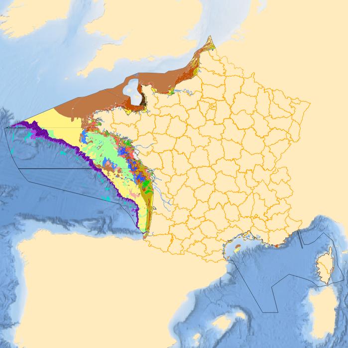
DCSMM2018 - D6C3 : Etendue spatiale de chaque habitat impacté par une pression physique
Simple
- Date (Creation)
- 2017-09-01
- Date (Publication)
- 2018-04-06
- Identifier
- DCSMM2018_D6C3_BRGM_HABITATS_IMPACTES
- Identifier
- DOI:10.12770/ae7ee082-f95d-4c8e-b69c-81b7451479a1
- Credit
- BRGM
- Thèmes Sextant
-
- /Activités humaines/Divers
- GEMET - INSPIRE themes, version 1.0
-
- Régions maritimes
- Theme
-
- Pressions physiques
- Fonds marins
- Activités humaines
- Données ouvertes
- DCSMM : Descripteurs
-
- D6: Intégrité des fonds marins
- D1: Biodiversité
- AES : Analyse Economique et Sociale
- Carpe Diem
- D7: Changements hydrographiques
- Sous-regions marines
-
- /Métropole
- Place
-
- Nationale
- Cadre Réglementaire - SIMM
-
- Directive Cadre pour la Planification de l'Espace Maritime (DCPEM)
- Directive Cadre Stratégie pour le Milieu Marin (DCSMM)
- Thématiques - SIMM
-
- /Etat du Milieu/Habitats
- Use limitation
- Données sous Licence Creative Commons - Attribution (BY) : http://creativecommons.fr/licences/
- Access constraints
- License
- Use constraints
- Copyright
- Spatial representation type
- vector Vector
- Denominator
- 50000
- Metadata language
- Français
- Character set
- utf8 UTF8
- Topic category
-
- Environment
))
- Reference system identifier
- EPSG / WGS 84 (EPSG:4326) / 8.6
- Geometric object type
- Surface
- Distribution format
-
-
ESRI Shapefile
(
1.0
)
-
ESRI Shapefile
(
1.0
)
- OnLine resource
-
DCSMM2018_D6C3_GDGN
(
OGC:WMS
)
Golfe de Gascogne nord
- Protocol
- FILE
- Name
- DCSMM2018_D6C3_GDGN
- Description
- Golfe de Gascogne nord
- OnLine resource
-
DCSMM2018_D6C3_GDGS
(
OGC:WMS
)
Golfe de Gascogne sud
- Protocol
- FILE
- Name
- DCSMM2018_D6C3_GDGS
- Description
- Golfe de Gascogne sud
- OnLine resource
-
DCSMM2018_D6C3_MC
(
OGC:WMS
)
Mers celtiques
- Protocol
- FILE
- Name
- DCSMM2018_D6C3_MC
- Description
- Mers celtiques
- OnLine resource
-
DCSMM2018_D6C3_MMN
(
OGC:WMS
)
Manche est Mer du nord
- Protocol
- FILE
- Name
- DCSMM2018_D6C3_MMN
- Description
- Manche est Mer du nord
- OnLine resource
-
DCSMM2018_D6C3_MO
(
OGC:WMS
)
Méditerranée occidentale
- Protocol
- FILE
- Name
- DCSMM2018_D6C3_MO
- Description
- Méditerranée occidentale
- OnLine resource
-
DOI du jeu de données
(
DOI
)
DOI du jeu de données
Format consistency
Conformance result
- Date (Creation)
- 2012-01-16
- Explanation
- Non évalué
- Statement
- Données réalisées dans le cadre de la DCSMM 2018 pour l'indicateur D6C3. Pour plus de renseignements voir le rapport RP-67420-FR du BRGM.
- Description
- Surfaces calculées en RGF93/Lambert 93 (EPSG:2154)
- Rationale
- Calcul
- Source
-
- EUSeaMap2 (2016) Broad-Scale Predictive Habitat Map
- EUSeaMap2 (2016) Broad-Scale Predictive Habitat Map - MSFD Predominant Habitats
- Habitats benthiques
- EUSeaMap2 (2016) Broad-Scale Predictive Habitat Map - Confidence
- Carte des zones biologiques en France métropolitaine (échelle 1 / 300 000) - Version 2011
- Carte d’habitats physiques des fonds marins en France métropolitaine (échelle 1 / 300 000) - Version 2011
- Carte d’habitats physiques des fonds marins en France métropolitaine (échelle 1 / 1 000 000) - Version 2011
- File identifier
- ae7ee082-f95d-4c8e-b69c-81b7451479a1 XML
- Metadata language
- Français
- Character set
- UTF8
- Hierarchy level
- Dataset
- Date stamp
- 2025-05-15T23:44:47.721106Z
- Metadata standard name
- ISO 19115-3 - SEXTANT ISO 19115-3 - SEXTANT
- Metadata standard version
- 1.0
Overviews
Spatial extent
Provided by
