Catalogue PIGMA
A Data Set of Sea Surface Stereo Images to Resolve Space-Time Wave Fields
Simple
- Date (Creation)
- 2017-12-25
- Date (Publication)
- 2019-11-26
- Identifier
- FR-330-715-368-00032-DATARMOR_SEA_SURFACE_STEREO_WAVE
- Identifier
- DOI:10.12770/af599f42-2770-4d6d-8209-13f40e2c292f
- Credit
- Fabrice Ardhuin, Alvise Benetazzo, Pedro Veras Guimaraes
- GEMET - INSPIRE themes, version 1.0
-
- Meteorological geographical features
- Thèmes Sextant
-
- /Physical Environment/Climatology
- Keywords
-
- Stereo video
- ocean waves
- wave breaking
- sea surface elevation
- ODATIS aggregation parameters and Essential Variable names
-
- Sea surface height
- Waves
- Type de jeux de donnée ODATIS
-
- /Observational data/in-situ
- Use limitation
- CC-BY (Creative Commons - Attribution)
- Access constraints
- License
- Use constraints
- License
- Other constraints
- CC-BY (Creative Commons - Attribution)
- Spatial representation type
- grid Grid
- Metadata language
- English
- Character set
- utf8 UTF8
- Topic category
-
- Oceans
- Begin date
- 2011-09-30
- End date
- 2018-01-02
- Reference system identifier
- EPSG / WGS 84 (EPSG:4326) / 8.6
- Topology level
- Geometry only
- Number of dimensions
- 2
- Dimension name
- Column
- Dimension name
- Row
- Cell geometry
- Area
- Distribution format
-
-
(
)
-
(
)
- OnLine resource
-
Publication
(
WWW:LINK
)
Stereo imaging and X-band radar wave data fusion: An assessment
- OnLine resource
-
DOI of the dataset
(
DOI
)
DOI of the dataset
- OnLine resource
- /home/ref-stereo ( NETWORK:LINK )
- OnLine resource
- Download link ( WWW:DOWNLOAD )
- Hierarchy level
- Dataset
- Statement
-
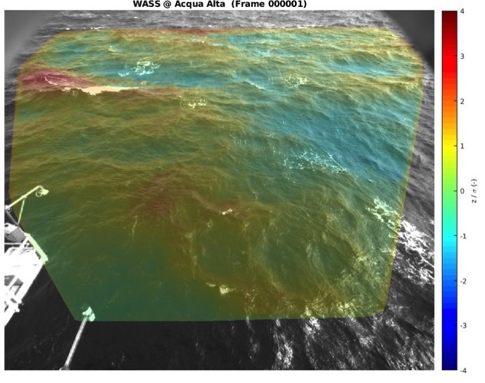
Stereo imaging measurement of the sea surface elevation is based on single snapshots or time records captured by a pair of synchronized and calibrated cameras. As a general principle, stereo imaging results in a surface elevation map zeta(x, y, t)in the horizontal physical 2-D space {x} = (x, y) and time {t}. The coverage area, accuracy, and resolution depend mostly on the experimental setup (e.g. the distance between the cameras), camera specifications, and lenses. One of the greatest advantage of having the space-time elevation field zeta(x, y, t) is to compute the 3-D wavenumber/frequency spectrum without the need of invoking any (e.g. linear) wave theory for background noise removal and signal selection. This is most important for the short wave components, for which nonlinear contributions are more significant.
This observation technique is very powerful to investigate many different process related to the sea surface and it brings a new perspective to investigate ocean waves, specially at mid to short scales. Stereo imaging connects the missing information between large to small-scale ocean observations (i.g, 10~m pixel resolution by SAR images) or a single point high frequency observation (wave gauge, moored buoys and others).
In this context, stereo video have been prof to be useful to explore different aspects of ocean waves.
We aim at presenting a valuable stereo-image data set, free available for the scientific community. This data set contains original records, calibration files, configuration files for processing, and examples of post-processed surface elevation maps collected during several oceanic campaigns, at different locations around the world ocean and under different sea state conditions. All this makes this data set especially useful to explore a common framework to investigate ocean waves and the sea surface dynamics.
- File identifier
- af599f42-2770-4d6d-8209-13f40e2c292f XML
- Metadata language
- English
- Character set
- UTF8
- Hierarchy level
- Dataset
- Date stamp
- 2025-12-12T21:54:58.951014Z
- Metadata standard name
- ISO 19115-3 - SEXTANT
- Metadata standard version
- 1.0