 Catalogue PIGMA
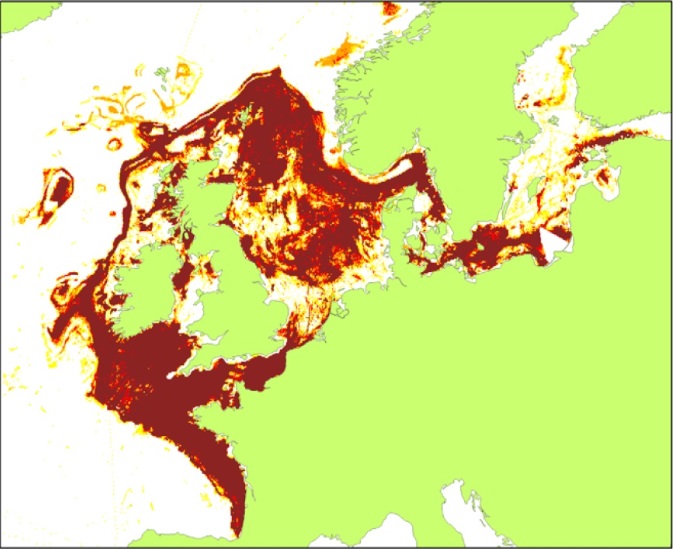
Fish and shellfish catch statistics | Fishing intensity | International Council for the Exploration of the Sea (ICES) | Fishing Intensity in the OSPAR and HELLCOM regions
Simple
- Alternate title
- Fishing Intensity in the OSPAR and HELLCOM regions
- Date
- Identifier
- Fish and shellfish catch statistics | Fishing intensity | International Council for the Exploration of the Sea (ICES) | Fishing Intensity in the OSPAR and HELLCOM regions
- Other citation details
- Fishing Intensity in the OSPAR and HELLCOM regions
- Purpose
- To show the extent of Fishing Intensity in the OSPAR and HELLCOM regions.
- Status
- onGoing On going
edmerp
Working Group on Spatial Fisheries Data
-
WGSFD
http://www.ices.dk/community/groups/Pages/WGSFD.aspx
http://www.ices.dk/community/groups/Pages/WGSFD.aspx
edmo
International Council for the Exploration of the Sea (ICES)
+45 3393 4215
http://www.ices.dk
H. C. Andersens Boulevard 44-46
,
Copenhagen V
,
DK-1553
,
Denmark
+45 3338 6700
+45 3393 4215
http://www.ices.dk
Originator
International Council for the Exploration of the Sea (ICES)
+45 3393 4215
http://www.ices.dk
H. C. Andersens Boulevard 44-46
,
Copenhagen V
,
DK-1553
,
Denmark
+45 3338 6700
+45 3393 4215
http://www.ices.dk
- Maintenance and update frequency
- Annually
- Used by challenges
-
- Atlantic - CH07 - Fisheries Impact
- Environmental matrix
-
- Human activities
- Production mode
-
- Delayed
- Visibility
-
- Information retrieved upon specific request to the data source
- Policy visibility
-
- There is information, but details are available only on request
- Readyness
-
- Format not or not well documented
- Parameter Discovery Vocabulary (P02)
-
- Fish and shellfish catch statistics
- GEMET - INSPIRE themes, version 1.0
-
- Species distribution
- Processing level of characteristics
-
- High level analyzed
- Data delivery mechanisms
-
- No information was found on data delivery mechanisms
- Parameter Usage Vocabulary (other)
-
- Fishing intensity
- Agreed Parameter Groups (P03)
-
- Fisheries
- Service extent
-
- Data sets are not referenced in a catalogue or are referenced in a non public catalogue
- Validation
-
- Submitted
- Access constraints
- Other restrictions
- Other constraints
- Not or not well documented
- Use limitation
- Not or not well documented
- Spatial representation type
- vector Vector
- Distance
- 5000 meter
- Metadata language
- Français
- Character set
- utf8 UTF8
- Topic category
-
- Oceans
- Environment description
- To spatially resolve vulnerable habitats in relation to fished areas in European waters to quantify the impact of anthropogenic activities on sensitive habitats
N
S
E
W
))
- Begin date
- 2012-12-01
- End date
- 2015-12-31
Vertical extent
- Minimum value
- 0
- Maximum value
- 2000
- Dimension name
- Time
- Transformation parameter availability
- Yes
- Checkpoint Availability
- Yes
- Distribution format
-
-
GeoTIFF
()
-
GeoTIFF
()
- OnLine resource
- N/A ( WWW:LINK )
- OnLine resource
- Fishing Intensity in the OSPAR and HELLCOM regions ( WWW:LINK )
- Hierarchy level
- Dataset
Domain consistency
- Name of measure
- Responsiveness
Quantitative result
- Value
- No information is found on response time
Domain consistency
- Name of measure
- Reliability
Quantitative result
- Attribute description
- observation
- Content type
- Physical measurement
- File identifier
- dff5ac64-5d0b-4034-843c-de6040312335 XML
- Metadata language
- English
- Character set
- UTF8
- Hierarchy level
- Dataset
- Hierarchy level name
- Atlantic - CH07 - Fisheries Impact
- Date stamp
- 2018-02-23T15:49:10Z
- Metadata standard name
- ISO 19115-3 - Emodnet Checkpoint - Upstream Data
- Metadata standard version
- 1.0
Overviews
Spatial extent
N
S
E
W
Provided by

Associated resources
Not available