 Catalogue PIGMA
Fishing effort | Fishing_Effort | The International Council for the Exploration of the Sea | 26092017_ExtractionVMS_UK_AND_EST
Simple
- Alternate title
- 26092017_ExtractionVMS_UK_AND_EST
- Date
- Identifier
- Fishing effort | Fishing_Effort | The International Council for the Exploration of the Sea | 26092017_ExtractionVMS_UK_AND_EST
- Other citation details
- Individual Country Vessels anonymized and Agregated submission (input data in untreated form delivered to ICES)
- Purpose
- VMS/Logbook data for fishing activities in the North East Atlantic for the provision of ICES management advice on spatial distribution and impact of fisheries 2009-2016
- Status
- onGoing On going
http://www.ices.dk/community/groups/Pages/WGSFD.aspx
- Maintenance and update frequency
- Unknown
- Used by challenges
-
- Atlantic - CH07 - Fisheries Impact
- Environmental matrix
-
- Human activities
- Production mode
-
- Delayed
- Visibility
-
- Information retrieved upon specific request to the data source
- Policy visibility
-
- There is information, but details are available only on request
- Readyness
-
- Format proprietary but content clearly specified
- Parameter Discovery Vocabulary (P02)
-
- Fishing effort
- GEMET - INSPIRE themes, version 1.0
-
- Sea regions
- Processing level of characteristics
-
- High level analyzed
- Data delivery mechanisms
-
- Manual process: Order form/invoice is requested
- Parameter Usage Vocabulary (other)
-
- Fishing_Effort
- Agreed Parameter Groups (P03)
-
- Human activity
- Service extent
-
- Data sets are not referenced in a catalogue or are referenced in a non public catalogue
- Validation
-
- Draft
- Access constraints
- Other restrictions
- Other constraints
- Restricted
- Use limitation
- N\A
- Spatial representation type
- vector Vector
- Distance
- 3000 meter
- Metadata language
- Français
- Character set
- utf8 UTF8
- Topic category
-
- Oceans
- Environment description
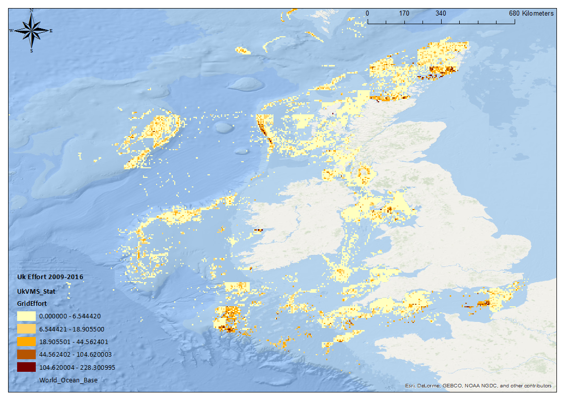
- This data set describes the fishing effort by the UK fishing fleet in the NE Atlantic Ocean from 2009 - 2016. the output data associated with this data set is P1_TotalEffort2009-2016, which maps the monthly effort per year.
))
- Begin date
- 2009
- End date
- 2016
Vertical extent
- Dimension name
- Time
- Resolution
- 1 month
- Transformation parameter availability
- Yes
- Checkpoint Availability
- Yes
- Hierarchy level
- Dataset
Domain consistency
- Name of measure
- Responsiveness
Quantitative result
- Value
- No information is found on response time
- Hierarchy level
- datasetComponent
- Other
- ATLANTIC_CH07_Product_1_1
))
- Begin date
- 2009
- End date
- 2016 After
Vertical extent
- Minimum value
- 0
- Maximum value
- 1000
Completeness omission
- Name of measure
- Horizontal Spatial Coverage
- Measure identification
- AP.1.1
- Measure description
- Horizontal coverage extent of product (eg : surface of the Mediterranean Sea)
Quantitative result
- Value type
- Real
- Value
- 399685
gmd:DQ_DescriptiveResult
- Date / Time
- 2018-01-30T00:00:00
- Statement
- Proportion of EU EEZ's where depth to the seafloor is equal or less than 1000m
Completeness omission
- Name of measure
- Vertical Spatial Coverage
- Measure identification
- AP.1.2
- Measure description
- Vertical coverage extent of product
Quantitative result
- Value type
- Real
- Value
- 1000
gmd:DQ_DescriptiveResult
- Date / Time
- 2018-01-30T00:00:00
- Statement
- A ban on fishing trawling below a depth of 800 meters in the North-East Atlantic was enacted by parliament in Dec 2016 . 1000m selected to give a buffer affect
Completeness omission
- Name of measure
- Temporal Coverage
- Measure identification
- AP.1.3
- Measure description
- Temporal coverage extent of product
Quantitative result
- Value type
- Integer
- Value
- 2921
gmd:DQ_DescriptiveResult
- Date / Time
- 2018-01-30T00:00:00
- Statement
- 8 Years
Completeness omission
- Name of measure
- Number of items
- Measure identification
- AP.1.4
- Measure description
- Count of all items in the dataset or sample. Describe the items which are counted. If the number is determined by sampling unit (density), define the sampling unit (eg size of mesh).
Quantitative result
- Value type
- Integer
- Value
- 2
gmd:DQ_DescriptiveResult
- Date / Time
- 2018-01-30T00:00:00
- Statement
- EU Data Collection Framework Correspondents : UK and Estonia
Conceptual consistency
- Name of measure
- Number of Characteristics
- Measure identification
- AP.2.1
- Measure description
- Number of characteristics in product
Quantitative result
- Value type
- Integer
gmd:DQ_DescriptiveResult
- Date / Time
- 2018-01-30T00:00:00
- Statement
- Fishing Effort
Thematic classification correctness
- Name of measure
- Horizontal resolution
- Measure identification
- AP.3.1
- Measure description
- Horizontal mesh size or equivalent value for the given scale of product (eg 50m for 1/50 000)
Quantitative result
- Value type
- Integer
- Value
- 3000
gmd:DQ_DescriptiveResult
- Date / Time
- 2018-01-30T00:00:00
- Statement
- Horizontal resolution of C-Square grid
Thematic classification correctness
- Name of measure
- Vertical resolution
- Measure identification
- AP.3.2
- Measure description
- Average vertical sampling
Quantitative result
- Value type
- Real
gmd:DQ_DescriptiveResult
- Date / Time
- 2018-01-30T00:00:00
- Statement
- N\A
Thematic classification correctness
- Name of measure
- Temporal resolution
- Measure identification
- AP.3.3
- Measure description
- Temporal sampling interval of product
Quantitative result
- Value type
- Real
- Value
- 30
gmd:DQ_DescriptiveResult
- Date / Time
- 2018-01-30T00:00:00
- Statement
- Mean number of days in a calendar month
Quantitative attribute accuracy
- Name of measure
- Thematic accuracy
- Measure identification
- AP.3.4
- Measure description
- Percentage error of the product and description of error concept for the product (100 words max) provided by expert
Quantitative result
- Value type
- Percentage
- Statement
- N\A
Temporal validity
- Name of measure
- Temporal validity
- Measure identification
- AP.4.1
- Measure description
- Max elapsed time between last input data records update and product creation date. Minimum value 1/24 day.
Quantitative result
- Value type
- Integer
gmd:DQ_DescriptiveResult
- Date / Time
- 2018-01-30T00:00:00
- Statement
- N\A
gmd:DQ_UsabilityElement
- Name of measure
- Usability
- Measure identification
- AP.5.1
- Value
- Inadequate
gmd:DQ_DescriptiveResult
- Date / Time
- 2018-01-30T00:00:00
- Statement
- Data made available by the UK and Estonia (Effort data from Estonia not relevant to the Atlantic). Data from remaining DCF correspondents not made available; resulting in underestimation of fishing effort as a proportion of total effort present.
Completeness omission
- Name of measure
- Horizontal spatial coverage compliance
- Measure identification
- UD.APE.1.1
- Measure description
-
Percentage to which the extent of the horizontal spatial
coverage of the selected input data is not compliant with the DPS extent in km**2
(UD_AP_1_1 - DPS_AP_1_1)*100/DPS_AP_1_1
Quantitative result
- Value type
- Percentage
- Value
- -56.85694794358486
Completeness omission
- Name of measure
- Horizontal spatial coverage fitness for use error
- Measure identification
- UD.FU.1.1
- Measure description
-
Combination of the errors of the product
component Cn with the error of the selected input data set Ud Cn used for this component
- Value
- -56.85694794358486
Completeness omission
- Name of measure
- Vertical spatial coverage compliance
- Measure identification
- UD.APE.1.2
- Measure description
-
Percentage to which the vertical coverage of the selected
input data is not compliant with the DPS coverage extent in metres
(UD_AP_1_2 - DPS_AP_1_2)*100/DPS_AP_1_2
Quantitative result
- Value type
- Percentage
- Value
- 0
Completeness omission
- Name of measure
- Vertical spatial coverage fitness for use error
- Measure identification
- UD.FU.1.2
- Measure description
-
Combination of the errors of the product
component Cn with the error of the selected input data set Ud Cn used for this component
- Value
- 0
Completeness omission
- Name of measure
- Temporal coverage compliance
- Measure identification
- UD.APE.1.3
- Measure description
-
Percentage to which the time coverage of the selected input data is compliant with the DPS coverage extent in days
(UD_AP_1_3 - DPS_AP_1_3)*100/DPS_AP_1_3
Quantitative result
- Value type
- Percentage
- Value
- -19.972602739726028
Completeness omission
- Name of measure
- Temporal coverage fitness for use error
- Measure identification
- UD.FU.1.3
- Measure description
-
Combination of the errors of the product
component Cn with the error of the selected input data set Ud Cn used for this component
- Value
- -19.972602739726028
Completeness omission
- Name of measure
- Number of items compliance
- Measure identification
- UD.APE.1.4
- Measure description
-
Percentage to which the number of items of the selected input data is compliant with the DPS number of items in days
(UD_AP_1_4 - DPS_AP_1_4)*100/DPS_AP_1_4
Quantitative result
- Value type
- Percentage
- Value
- -84.61538461538461
Completeness omission
- Name of measure
- Error count fitness for use error
- Measure identification
- UD.FU.1.4
- Measure description
-
Combination of the errors of the product
component Cn with the error of the selected input data set Ud Cn used for this component
- Value
- -84.61538461538461
Thematic classification correctness
- Name of measure
- Horizontal resolution compliance
- Measure identification
- UD.APE.3.1
- Measure description
-
Percentage to which the horizontal resolution or equivalent scale value (eg 50 m for map scale of 1/50 000) data
or mean horizontal sampling interval of the selected input data is compliant not with the DPS horizontal
resolution
(DPS_AP_3_1 - UD_AP_3_1)*100/DPS_AP_3_1
Quantitative result
- Value type
- Percentage
- Value
- -200
Thematic classification correctness
- Name of measure
- Horizontal resolution fitness for use error
- Measure identification
- UD.FU.3.1
- Measure description
-
Combination of the errors of the product
component Cn with the error of the selected input data set Ud Cn used for this component
- Value
- -100
Thematic classification correctness
- Name of measure
- Vertical resolution compliance
- Measure identification
- UD.APE.3.2
- Measure description
-
Percentage to which the vertical sampling interval of the selected input data is not compliant with the DPS
vertical resolution
(DPS_AP_3_2 - UD_AP_3_2)*100/DPS_AP_3_2
Quantitative result
- Value type
- Percentage
Thematic classification correctness
- Name of measure
- Vertical resolution fitness for use error
- Measure identification
- UD.FU.3.2
- Measure description
-
Combination of the errors of the product
component Cn with the error of the selected input data set Ud Cn used for this component
Thematic classification correctness
- Name of measure
- Temporal resolution compliance
- Measure identification
- UD.APE.3.3
- Measure description
-
Percentage to which the temporal sampling interval
is not compliant with the DPS temporal sampling interval
(DPS_AP_3_3-UD_AP_3_3)*100/DPS_AP_3_3
Quantitative result
- Value type
- Percentage
- Value
- 0
Thematic classification correctness
- Name of measure
- Temporal resolution fitness for use error
- Measure identification
- UD.FU.3.3
- Measure description
-
Combination of the error of the product
component Cn with the error of the selected input data set Ud Cn used for this component
- Value
- 0
Quantitative attribute accuracy
- Name of measure
- Thematic accuracy compliance
- Measure identification
- UD.APE.3.4
- Measure description
-
Compliance of the value domain of
the accuracy of the selected input data with the value domain of the accuracy defined in DPS (% extracted from
thematic accuracy description)
UD_AP_3_4
Quantitative result
- Value type
- Percentage
Quantitative attribute accuracy
- Name of measure
- Thematic accuracy fitness for use error
- Measure identification
- UD.FU.3.4
- Measure description
-
Combination of the error of the product
component Cn with the error of the selected input data set Ud Cn used for this component
Temporal validity
- Name of measure
- Temporal validity compliance
- Measure identification
- UD.APE.4.1
- Measure description
-
Percentage to which the elapsed time between last selected input data record update is not compliant with the max
elapsed time specified in DPS
(DPS_AP_4_1 - UD_AP_4_1)*100/DPS_AP_4_1
Quantitative result
- Value type
- Percentage
Temporal validity
- Name of measure
- Temporal validity fitness for use error
- Measure identification
- UD.FU.4.1
- Measure description
-
Combination od errors of extent to which
the elapsed time between last selected input data record update and the product creation date is compliant with
the max elapsed time specified in DPS
- Attribute description
- observation
- Content type
- Physical measurement
- File identifier
- 081005d7-2b2e-47f5-b972-b638fb4bcada XML
- Metadata language
- English
- Character set
- UTF8
- Hierarchy level
- Dataset
- Hierarchy level name
- Atlantic - CH07 - Fisheries Impact
- Date stamp
- 2019-05-28T14:21:35Z
- Metadata standard name
- ISO 19115-3 - Emodnet Checkpoint - Upstream Data
- Metadata standard version
- 1.0
Overviews
Spatial extent
Provided by
