 Catalogue PIGMA
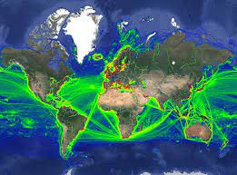
Global Shipping Traffic Density
This data was obtained through a partnership with IMF, as part of IMF's World Seaborne Trade Monitoring System (Cerdeiro, Komaromi, Liu and Saeed, 2020). The data analysis was supported by the World Bank’s ESMAP and PROBLUE programs.
The dataset contains 6 density layers, with vessel types aggregated to suit the needs of the WBG Offshore Wind Development Program:
1) Commercial ships
2) Fishing ships
3) Oil & Gas [note: this is just platforms, rigs, and FPSOs]
4) Passenger ships
5) Leisure vessels
6) GLOBAL ship density layers of all ship categories combined
Simple
- Date (Revision)
- 2021-05-03
- Date (Publication)
- 2020-01-01
- Identifier
- 18267ef1-14c2-4fa2-865c-2c21e71b2c67
- Credit
- The World Bank
- Thèmes Sextant
-
- /Human Activities
- GEMET - INSPIRE themes, version 1.0
-
- Transport networks
- Mission Atlantic - Resources
-
- Data
- Mission Atlantic - BODC Parameters
-
- /Human activities/Transport
- Mission Atlantic - Data type (DMP)
-
- Spatial data products
- Mission Atlantic - Work Package
-
- WP3 Pelagic Mapping
- WP4 Benthic Mapping
- Mission Atlantic - Case Studies
-
- Atlantic Ocean
- Use limitation
- CC-BY (Creative Commons - Attribution)
- Access constraints
- Copyright
- Use constraints
- Copyright
- Spatial representation type
- grid Grid
- Distance
- 0.005 degree
- Metadata language
- English
- Character set
- utf8 UTF8
- Topic category
-
- Oceans
))
- Begin date
- 2015-01-01
- End date
- 2021-02-01 After
- Unique resource identifier
- EPSG:4326
Spatial representation info
- Distribution format
-
-
GeoTIFF
(
1.0
)
-
GeoTIFF
(
1.0
)
- OnLine resource
- Access data ( WWW:LINK )
- OnLine resource
- World Seaborne Trade in Real Time: A Proof of Concept for Building AIS-based Nowcasts from Scratch ( WWW:LINK-1.0-http--publication-URL )
- Hierarchy level
- Dataset
- Statement
-
The raster layers were created using IMF's analysis of hourly AIS positions received between Jan-2015 and Feb-2021 and represent the total number of AIS positions that have been reported by ships in each grid cell with dimensions of 0.005 degree by 0.005 degree (approximately a 500m x 500m grid at the Equator).
The AIS positions may have been transmitted by both moving and stationary ships within each grid cell, therefore the density is analogous to the general intensity of shipping activity.
- File identifier
- 18267ef1-14c2-4fa2-865c-2c21e71b2c67 XML
- Metadata language
- English
- Character set
- UTF8
- Hierarchy level
- Dataset
- Date stamp
- 2025-05-15T21:29:55.159025Z
- Metadata standard name
- ISO 19115-3 - SEXTANT
- Metadata standard version
- 1.0
Overviews
Spatial extent
Provided by
