 Catalogue PIGMA
Temperature of the water column | Temperature of the water body | IFREMER-METATOUR1 |
Simple
- Date
- Identifier
- Temperature of the water column | Temperature of the water body | IFREMER-METATOUR1 |
- Purpose
- Determining the chemical speciation of metallic contaminants (Hg, TBT, Cu, Cd) at the water-sediment interface with respect to their bioavailability (labile or complex forms) or to their toxicity (organometallic complexes).
- Status
- onGoing On going
Originator
UNIVERSITE DE PAU / LAB.CHIMIE BIO INORGANIQUE & ENVIRONNEMENT
https://edmo.seadatanet.org/report/1094
https://edmo.seadatanet.org/report/1094
- Maintenance and update frequency
- As needed
- Used by challenges
-
- Atlantic - CH09 - River Inputs
- Environmental matrix
-
- Fresh water
- Production mode
-
- Delayed
- Visibility
-
- Search via reference catalogue (e.g. MyOcean, GEOSS Geoportal…)
- Policy visibility
-
- There is detailed information provided to understand data policy
- Readyness
-
- Format not proprietary but content not clearly specified
- Parameter Discovery Vocabulary (P02)
-
- Temperature of the water column
- GEMET - INSPIRE themes, version 1.0
-
- Hydrography
- Processing level of characteristics
-
- Observation (raw, QC)
- Data delivery mechanisms
-
- Online discovery and downloading services
- Parameter Usage Vocabulary (P01)
-
- Temperature of the water body
- Agreed Parameter Groups (P03)
-
- Water column temperature and salinity
- Service extent
-
- The datasets are provided through an EU Inspire catalogue service (OGC)
- The datasets are referenced in a public national catalogue, in an international catalogue service
- Access constraints
- Other restrictions
- Other constraints
- Restricted
- Use limitation
- Free of charge for academic institutions and uses
- Spatial representation type
- vector Vector
- Metadata language
- Français
- Character set
- utf8 UTF8
- Topic category
-
- Oceans
- Environment description
- Temperature temporal series.
N
S
E
W
))
- Begin date
- 2001-06-14
- End date
- 2001-06-20
Vertical extent
- Dimension name
- Time
- Resolution
- isolated measurement
- Transformation parameter availability
- Yes
- Checkpoint Availability
- Yes
- Distribution format
-
-
MEDATLAS
()
-
MEDATLAS
()
- OnLine resource
- EMODNET Chemistry ( WWW:LINK )
- Protocol
- WWW:LINK
- Name
- 2001480030
- Hierarchy level
- Dataset
Domain consistency
- Name of measure
- Responsiveness
Quantitative result
- Value
- No information is found on response time
Domain consistency
- Name of measure
- Reliability
Quantitative result
- Hierarchy level
- datasetComponent
N
S
E
W
))
- Begin date
- 2005-01-01
- End date
- 2014-12-31
- Other
- ATLANTIC_CH09_Specification_5_1
Completeness omission
- Name of measure
- Horizontal Spatial Coverage
- Measure identification
- AP.1.1
- Measure description
- Horizontal coverage extent of product (eg : surface of the Mediterranean Sea)
Quantitative result
- Value type
- Real
gmd:DQ_DescriptiveResult
- Date / Time
- 2017-12-04T00:00:00
Completeness omission
- Name of measure
- Vertical Spatial Coverage
- Measure identification
- AP.1.2
- Measure description
- Vertical coverage extent of product
Quantitative result
- Value type
- Real
gmd:DQ_DescriptiveResult
- Date / Time
- 2017-12-04T00:00:00
Completeness omission
- Name of measure
- Temporal Coverage
- Measure identification
- AP.1.3
- Measure description
- Temporal coverage extent of product
Quantitative result
- Value type
- Integer
gmd:DQ_DescriptiveResult
- Date / Time
- 2017-12-04T00:00:00
Completeness omission
- Name of measure
- Number of items
- Measure identification
- AP.1.4
- Measure description
- Count of all items in the dataset or sample. Describe the items which are counted. If the number is determined by sampling unit (density), define the sampling unit (eg size of mesh).
Quantitative result
- Value type
- Integer
gmd:DQ_DescriptiveResult
- Date / Time
- 2017-12-04T00:00:00
Conceptual consistency
- Name of measure
- Number of Characteristics
- Measure identification
- AP.2.1
- Measure description
- Number of characteristics in product
Quantitative result
- Value type
- Integer
gmd:DQ_DescriptiveResult
- Date / Time
- 2017-12-04T00:00:00
Thematic classification correctness
- Name of measure
- Horizontal resolution
- Measure identification
- AP.3.1
- Measure description
- Horizontal mesh size or equivalent value for the given scale of product (eg 50m for 1/50 000)
Quantitative result
- Value type
- Integer
gmd:DQ_DescriptiveResult
- Date / Time
- 2017-12-04T00:00:00
Thematic classification correctness
- Name of measure
- Vertical resolution
- Measure identification
- AP.3.2
- Measure description
- Average vertical sampling
Quantitative result
- Value type
- Real
gmd:DQ_DescriptiveResult
- Date / Time
- 2017-12-04T00:00:00
Thematic classification correctness
- Name of measure
- Temporal resolution
- Measure identification
- AP.3.3
- Measure description
- Temporal sampling interval of product
Quantitative result
- Value type
- Real
gmd:DQ_DescriptiveResult
- Date / Time
- 2017-12-04T00:00:00
Quantitative attribute accuracy
- Name of measure
- Thematic accuracy
- Measure identification
- AP.3.4
- Measure description
- Percentage error of the product and description of error concept for the product (100 words max) provided by expert
Quantitative result
- Value type
- Percentage
Temporal validity
- Name of measure
- Temporal validity
- Measure identification
- AP.4.1
- Measure description
- Max elapsed time between last input data records update and product creation date. Minimum value 1/24 day.
Quantitative result
- Value type
- Integer
gmd:DQ_DescriptiveResult
- Date / Time
- 2017-12-04T00:00:00
gmd:DQ_UsabilityElement
- Name of measure
- Usability
- Measure identification
- AP.5.1
gmd:DQ_DescriptiveResult
- Date / Time
- 2017-12-04T00:00:00
- Attribute description
- observation
- Content type
- Physical measurement
- File identifier
- 3ca18ff1-70a2-4e55-b193-cd3c2168adb6 XML
- Metadata language
- English
- Character set
- UTF8
- Hierarchy level
- Series
- Hierarchy level name
- Atlantic - CH09 - River Inputs
- Date stamp
- 2018-02-16T14:32:49Z
- Metadata standard name
- ISO 19115-3 - Emodnet Checkpoint - Upstream Data
- Metadata standard version
- 1.0
Overviews
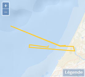
Spatial extent
N
S
E
W
N
S
E
W
Provided by

Associated resources
Not available