 Catalogue PIGMA
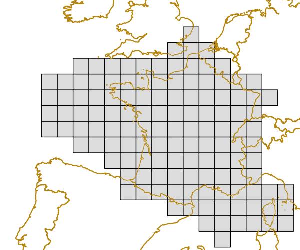
EEA reference grid for France (100km), May 2013
The grid is based on proposal at the 1st European Workshop on Reference Grids in 2003 and later INSPIRE geographical grid systems. The sample grid available here is part of a set of three polygon grids in 1, 10 and 100 kilometres. The grids cover at least country borders and, where applicable, marine Exclusive Economic Zones v7.0,
http://www.marineregions.org.
Note that the extent of the grid into the marine area does not reflect the extent of the territorial waters.
Simple
- Date (Publication)
- 2013-05-21
- Date (Creation)
- 2013-05-21
- Identifier
- eea_v_3035_100_km_eea-ref-grid-fr_p_2013_v02_r00
Point of contact
European Environment Agency
Kongens Nytorv 6
,
Copenhagen
,
K
,
1050
,
Denmark
http://www.eea.europa.eu
- EEA topics
-
- Biodiversity
- GEMET - INSPIRE themes, version 1.0
-
- Geographical grid systems
- Keywords
-
- Keywords
-
- Continents, countries, sea regions of the world.
-
- France
- GEMET
-
- gridding
- Sous-regions marines
-
- /Métropole
- /Métropole/Manche mer du Nord
- /Métropole/Mers Celtiques
- /Métropole/Golfe de Gascogne
- /Métropole/Méditerranée occidentale
- Thématiques - SIMM
-
- /Activités et Usages/Analyse économique et sociale
- Type de jeux de donnée - ODATIS
-
- /Données dérivées/Références statistiques
- Use constraints
- Other restrictions
- Other constraints
- License CC-BY 4.0 (https://creativecommons.org/licenses/by/4.0/). Copyright holder: European Environment Agency (EEA).
- Access constraints
- Other restrictions
- Other constraints
- no limitations to public access
- Spatial representation type
- vector Vector
- Distance
- 100 km
- Metadata language
- English
- Character set
- utf8 UTF8
- Topic category
-
- Location
N
S
E
W
))
- Begin date
- 2013-01-01T00:00:00
- End date
- 2013-12-31T00:00:00
- Unique resource identifier
- EPSG:3035
- Distribution format
-
-
SHP
(
)
-
SHP
(
)
- OnLine resource
- https://sdi.eea.europa.eu/webdav/datastore/public/eea_v_3035_100_km_eea-ref-grid-fr_p_2013_v02_r00/ ( EEA:FOLDERPATH )
- OnLine resource
- Direct download ( WWW:URL )
- Hierarchy level
- Dataset
Conformance result
- Date (Publication)
- 2010-12-08
- Explanation
- See the referenced specification
- Statement
- The reference grids are based on ETRS89 Lambert Azimuthal Equal Area projection with parameters: latitude of origin 52°N, longitude of origin 10°E, false northing 3210000.0m, false easting 4321000.0m. Origin of the grid is calculated from 0mN 0mE of projection. The method followed the instructions for the EEA fishnet tool described in the EEA GIS guideline available from http://www.eionet.europa.eu/gis. All grids have been created using one of the two scripts available in the scripts subfolder located in the data directory. Their usage is documented in the readme.txt file available in the same subfolder.
- File identifier
- 660ce4c2-6e23-4aca-b906-0996bdcf24acf XML
- Metadata language
- English
- Character set
- UTF8
- Hierarchy level
- Dataset
- Date stamp
- 2025-10-09T10:54:44.00409Z
- Metadata standard name
- ISO 19115/19139
- Metadata standard version
- 1.0
Overviews
Spatial extent
N
S
E
W
Provided by

Associated resources
Not available