 Catalogue PIGMA
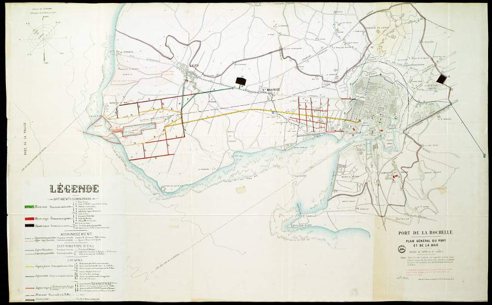
Port de la Rochelle - vers 1900 - 1PL1115
Thème : Port de La Rochelle
Date.edition :
Auteur.nom : A, Broise et Courtier 43 R, de Dunkerque, Paris
Auteur.date :
Intérêt : vers 1900 . Plan d’aménagement de la Rochelle (extension vers la Pallice).
Editeur :
Echelle : 1:10000
Taille :
Lieu d'archivage : Michel Crépeau, Patrimoine, Reserve A 1 PL 1115. Exclu du prêt, consultation sur place
Numéro d'archive : Plan Carte (No )
Indices :
Référence : 1 PL 1115
Simple
- Date (Creation)
- 2016-09-05
- Date (Publication)
- 2017-01-30
- Date (Revision)
- 2017-01-30
- Identifier
- FR-180-089-013-03720-LIENSs_dypomar_1_PL_1115_20161229
- Credit
- LIttoral ENvironnement et Sociétés - La Rochelle Université / CNRS
- GEMET - INSPIRE themes, version 1.0
-
- Régions maritimes
- Keywords
-
- Port de la Rochelle, plan du port, plan de la baie, Bassin de la Pallice, Môle du Lazaret, Tour Richelieu, Desserte eau, assainissement, distribution d'eau, bâtiments communaux
- Use limitation
- Utilisation libre sous réserve de mentionner la source (a minima le nom du producteur) et la date de sa dernière mise à jour.
- Access constraints
- Intellectual property rights
- Access constraints
- Other restrictions
- Other constraints
- Pas de restriction d’accès publique
- Classification
- Unclassified
- Spatial representation type
- grid Grid
- Metadata language
- Français
- Character set
- utf8 UTF8
- Topic category
-
- Imagery base maps earth cover
- Society
- Environment
))
))
))
- Begin date
- 1875-01-01
- End date
- 1875-01-01
- Reference system identifier
- EPSG / Lambert 93 / 7.4
- Reference system identifier
- INSPIRE RS registry / grégorien
- Distribution format
-
-
GeoTIFF
(
)
-
GeoTIFF
(
)
- OnLine resource
-
pyramid_1875
(
OGC:WMS
)
pyramid_1875
- Hierarchy level
- Dataset
- Statement
-
Carte réf. 1 PL 1115 fournie par la Médiathèque d’agglomération de La Rochelle en format numérique.
Géoréférencée le 05/09/2016 par N. Volto du LIENSs (9 points, transformation du 1er ordre, affine, avec le logiciel Arcgis (ESRI), version 10.3.1).
- File identifier
- 6c8569b9-7ee7-44c6-a508-ba888dfb13cb XML
- Metadata language
- Français
- Character set
- UTF8
- Hierarchy level
- Dataset
- Hierarchy level name
- Série de données
- Date stamp
- 2025-05-15T22:46:49.091942Z
- Metadata standard name
- ISO 19115-3 - SEXTANT
- Metadata standard version
- 1.0
Overviews
Spatial extent
Provided by
