 Catalogue PIGMA
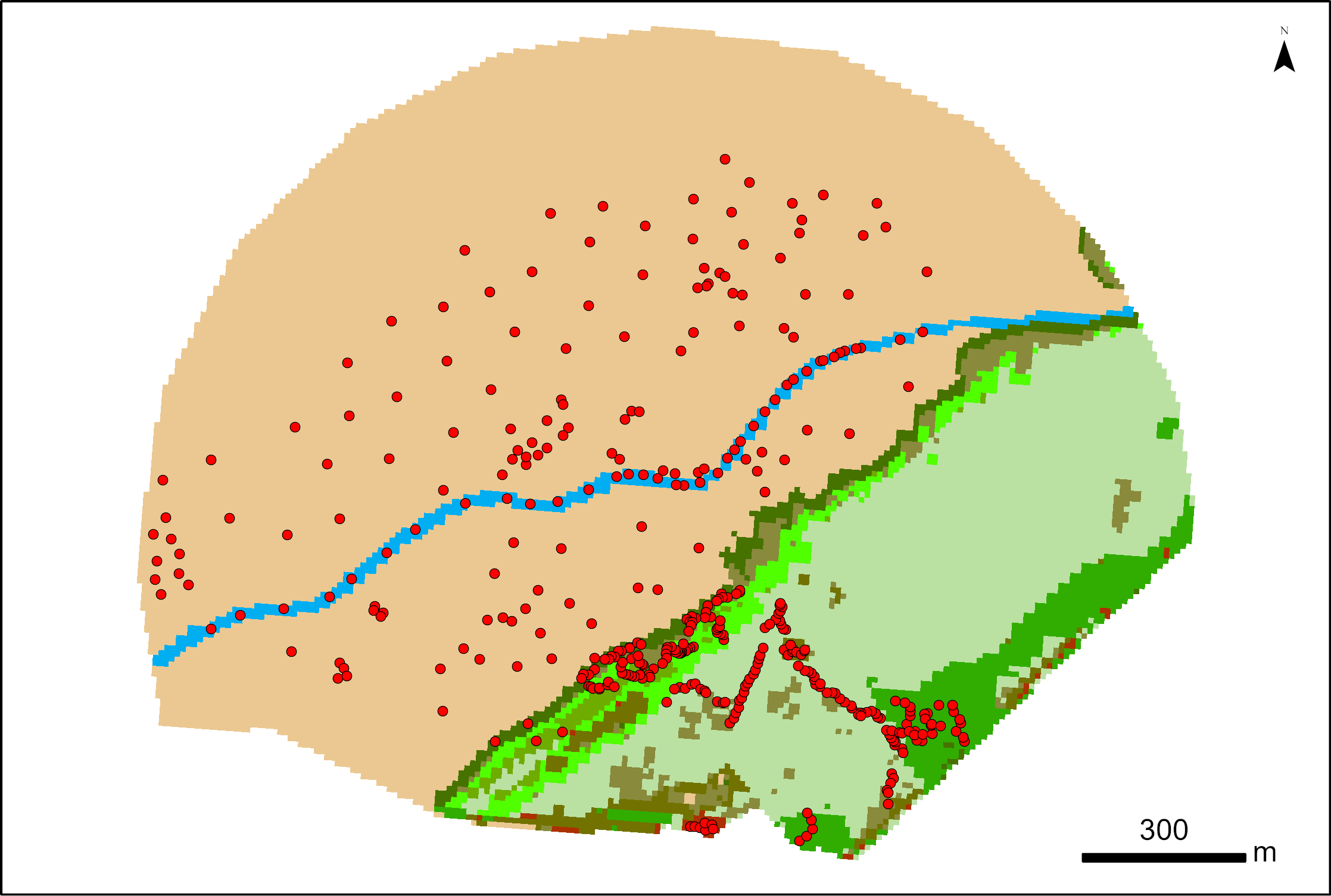
Vegetation survey on Esnandes - LRTZC project
387 points were surveyed with a SP80 DGPS by Maxime Paschal as part of the La Rochelle Zero Carbon Territory (LRTZC) project on 26/05/23. At each point, the type of vegetation was specified.
Simple
- Date (Creation)
- 2023-05-26T08:00:00
- Date (Publication)
- 2023-09-22T17:00:00+00:00
- Identifier
- FR-180-089-013-03720-LIENSs-vegetation_esnandes_LRTZC
- Credit
- LIttoral ENvironnement et Sociétés - La Rochelle Université / CNRS
- Status
- onGoing On going
Author
LIttoral ENvironnement et Sociétés (LIENSs)
-
LONG Nathalie
2 rue Olympe de Gouges
,
La Rochelle
,
17000
,
0546507665
Point of contact
LIttoral ENvironnement et Sociétés (LIENSs)
-
Service d'Aide à la Gestion de la Donnée
- Maintenance and update frequency
- As needed
- Keywords
-
- vegetation
- Use limitation
- CC-BY-NC-ND (Creative Commons - Attribution, Pas d’utilisation commerciale, Pas de modification)
- Access constraints
- Copyright
- Use constraints
- Copyright
- Spatial representation type
- vector Vector
- Denominator
- 1000
- Metadata language
- English
- Character set
- utf8 UTF8
- Topic category
-
- Environment
- Imagery base maps earth cover
- Begin date
- 2023-05-26T08:00:00+02:00
- End date
- 2023-05-26T18:00:00+02:00
N
S
E
W
))
- Reference system identifier
- EPSG / Lambert 93 (EPSG:2154) / 7.4
- Geometric object type
- Point
- Distribution format
-
-
ESRI Shapefile
(
10
)
-
ESRI Shapefile
(
10
)
Resource provider
Littoral ENvironnement et Sociétés (LIENSs) - UMR 7266 - CNRS
2 rue Olympe de Gouges
,
LA ROCHELLE
,
17000
,
FRANCE
- Protocol
- WWW:LINK
- OnLine resource
- LRTZC ( WWW:LINK )
- Hierarchy level
- Dataset
Absolute external positional accuracy
Conformance result
- Date (Creation)
- 2012-01-16
- Explanation
- Non évalué
- Pass
- No
- Description
- 387 points were surveyed with a SP80 DGPS by Maxime Paschal as part of the La Rochelle Zero Carbon Territory (LRTZC) project on 26/05/23. Some points were used as training samples to perform image classification without photo-interpretation errors, and others were used to validate the results. The typology of land cover classes was developed with the help of ecologists familiar with the different genera present in the studied salt marsh. To carry out the survey, the salt marsh was traversed following random transects and different orientations.
- File identifier
- 85f77068-e20b-4a7e-b7b0-c694a5dbd5d3 XML
- Metadata language
- English
- Character set
- UTF8
- Hierarchy level
- Dataset
- Date stamp
- 2025-11-28T11:06:08.736358Z
- Metadata standard name
- ISO 19115-3 - SEXTANT ISO 19115-3 - SEXTANT
- Metadata standard version
- 1.0
Overviews
thumbnail
large_thumbnail
Spatial extent
N
S
E
W
Provided by

Associated resources
Not available