 Catalogue PIGMA
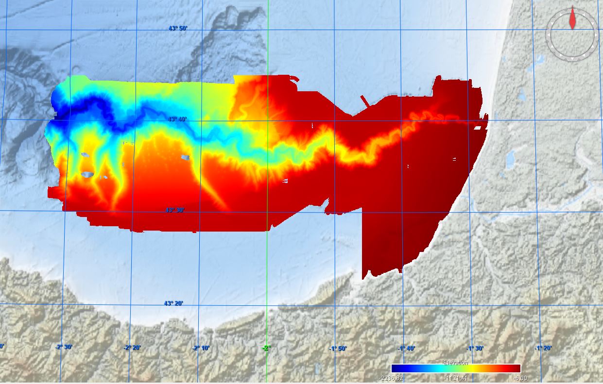
486_CAPBRETON_CANYON_GRIDDED_DATA_2007
Simple
- Date (Creation)
- 2024-01-05
- Date (Revision)
- Identifier
- MB_CAPBRETON_CANYON_2007
IFREMER Centre de Bretagne
ZI Pointe du diable
CS 10070
, PLOUZANE , 29280 , France+33(0)2 98.22.45.70
https://wwz.ifremer.fr/gm/
IFREMER Centre de Bretagne
ZI Pointe du diable
CS 10070
, PLOUZANE , 29280 , France+33 (0)2 98.22.46.44
http://data.ifremer.fr/SISMER
- Project name
-
- EMODNet Bathymetry
- SeaDataNet device categories
-
- single-beam echosounders
- multi-beam echosounders
- Parameter Discovery Vocabulary (P02)
-
- Bathymetry and Elevation
- GEMET - INSPIRE themes, version 1.0
-
- Hydrography
- SeaDataNet depth measurement reference planes
-
- sea level
- Access constraints
- Creative Commons Attribution 4.0 International
- Use constraints
- Other restrictions
- Other constraints
-
Do not use for navigation
Cite : BOURILLET Jean-Francois , AUGRIS Claude , CIRAC Pierre , MAZE Jean-Pierre , NORMAND Alain , LOUBRIEU Benoît , CRUSSON Alban , GAUDIN Mathieu , POIRIER Dominique , SATRA LE BRIS Catherine , SIMPLET Laure (2018). Bathymétrie - canyon de Capbreton (synthèse, édition 2007). Ifremer
http://dx.doi.org/10.12770/72e2f750-c255-11df-a9b6-005056987263
- Spatial representation type
- Grid
- Denominator
- 50000
- Distance
- 1.875 Arc second
- Metadata language
- English
- Character set
- UTF8
- Topic category
-
- Oceans
- Begin date
- 1993-01-01
))
- Description
-
Map projection parameters, values and units :
Axes units :
- Codespace
- EPSG
- Version
- 7.4
- Reference system identifier
- EPSG / WGS 84 (EPSG:4326) / 7.4
- Reference system identifier
- EPSG / WGS 84 (EPSG:4326) / 7.4
- Number of dimensions
- 3
- Dimension name
- Column
- Dimension size
- 2272
- Dimension name
- Row
- Dimension size
- 736
- Dimension name
- Time
- Dimension size
- 1
- Cell geometry
- Point
- Transformation parameter availability
- No
- Checkpoint Availability
- No
- Point in Pixel
-
- Center
- Distribution format
-
-
NetCDF
(
)
-
NetCDF
(
)
IFREMER Centre de Bretagne
ZI Pointe du diable
CS 10070
, PLOUZANE , 29280 , France+33 (0)2 98.22.46.44
http://data.ifremer.fr/SISMER
- Transfer size
- 40
- Protocol
- WWW:LINK
- Function
- Download
- OnLine resource
- EMODnet Bathymetry WMTS service ( WWW:LINK )
- Hierarchy level
- Dataset
Vertical extent
- Minimum value
- 6
- Maximum value
- 2240
Vertical CS
Vertical datum
- Statement
- no information
- Hierarchy level
- Feature
- Dataset
- accuracy
Gridded data positional accuracy
- Name of measure
- horizontal accuracy
- Measure identification
- horizontal accuracy of coordinate
Quantitative result
- Value type
- horizontal accuracy
Quantitative attribute accuracy
- Name of measure
- depth
- Measure identification
- depth accuracy
Quantitative result
- Value
- not defined
Conformance result
- Date
- Hierarchy level
- Software
- Other
- software
- Hierarchy level
- Property type
- Description
- parameters of data processing
- Attributes
- Statement
-
Description of data processing :
Data processing for the published grid is described in the published report
http://dx.doi.org/10.12770/72e2f750-c255-11df-a9b6-005056987263
- Description
-
Description of processed data sources :
Bathymetry surveys
- AUGRIS Claude (1993) PLABAS cruise, RV Thalia, https://doi.org/10.17600/93000660
- AUGRIS Claude (1994) PLABAS 94/2 cruise, RV Thalia, https://doi.org/10.17600/94070180
- LERICOLAIS Gilles, AUGRIS Claude (1995) PLACETA / PLABAS 3 cruise, RV Thalia, https://doi.org/10.17600/95070070
- CIRAC Pierre (1998) ITSAS cruise, RV Le Suroît, https://doi.org/10.17600/98020070
- CIRAC Pierre (2001) ITSAS II cruise, RV Le Suroît, https://doi.org/10.17600/1020050
- CIRAC Pierre (2001) ITSAS V cruise, RV Thalia, https://doi.org/10.17600/1070060
- CIRAC Pierre (2002) ITSAS VI cruise, RV Thalia, https://doi.org/10.17600/2070100
- CIRAC Pierre (2004) PROSECAN 2 cruise, RV Thalia, https://doi.org/10.17600/4070150
- Hierarchy level
- Dataset
Absolute external positional accuracy
- Name of measure
- emodnet-bathymetry.QI.Horizontal
- Value
- 2 - Between 50 m and 20 m
Absolute external positional accuracy
- Name of measure
- emodnet-bathymetry.QI.Vertical
- Value
- 2 - MBES low frequency (lower than 100kHz) (similar than 1+2%d)
Domain consistency
- Name of measure
- emodnet-bathymetry.QI.Purpose
- Value
- 2 - Bathymetric/morphologic survey
- File identifier
- SDN_CPRD_486_MB_CAPBRETON_CANYON_2007 XML
- Metadata language
- English
- Character set
- UTF8
- Hierarchy level name
- Product record
- Date stamp
- 2024-01-09T08:27:11.778Z
- Metadata standard name
- ISO 19115:2003/19139 - EMODNET - BATHYMETRY
- Metadata standard version
- 1.0
IFREMER Centre de Bretagne
ZI Pointe du diable
CS 10070
, PLOUZANE , 29280 , France+33(0)2 98.22.45.70
https://wwz.ifremer.fr/gm/
Overviews
Spatial extent
Provided by
