 Catalogue PIGMA
X-TRACK, Along track Tidal Constants (2018_01)
X-TRACK, is a regional altimeter products for coastal applications. Along-track tidal constants (amplitude, phase lags and associated estimation errors for 73 constituents) derived from the X-TRACK T/P and Jason 1&2 is available every 6-7 km along the satellite ground tracks.
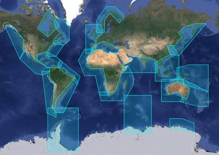
X-TRACK areas :
| short name | long name |
|:------------|:---------------------------------|
| adelie | Adelie-Mertz |
| amazon | Amazon |
| asa | Atlantic South America |
| chinasea | China Sea |
| drake | Drake passage |
| eaustralia | East Australia |
| gom | Gulf of Mexico - Caribbean Sea |
| gulfstream | Gulf Stream |
| hudson | Hudson Bay |
| humboldt | Humboldt current |
| kerguelen | Kerguelen Islands |
| labrador | Labrador Sea |
| medsea | Mediterranean Sea |
| nea | North East Atlantic |
| nindian | North Indian Ocean |
| norway | Norway |
| nwa | North West America |
| nwp | North West Pacific |
| sea | South and East Africa |
| wafrica | West Africa |
| waustralia | West Australia |
| wla | West Latin America - California |
| wtp | West Tropical Pacific |
Simple
- Date (Publication)
- 2018-05-01
- Identifier
- http://dx.doi.org/ / 10.6096/CTOH_X-TRACK_TIDAL_2018_01
- Credit
- SNO CTOH
- Status
- On going On going
- Maintenance and update frequency
- Annually Annually
- GEMET - INSPIRE themes, version 1.0
-
- Oceanographic geographical features
- Centre de données ODATIS
-
- CDS-OMP
- Type de jeux de donnée ODATIS
-
- /Observational data/in-situ
- Services Nationaux d'Observation
-
- SNO-CTOH
- Use limitation
- CTOH data policy, https://www.legos.omp.eu/ctoh/licence-dutilisation-des-produits-ctoh/
- Use limitation
- The data are provided without any warranty for any non-profit educational and research purposes.
- Other constraints
- No access conditions apply
- Metadata language
- EnglishEnglish
- Topic category
-
- Oceans
))
- Begin date
- 1995-05-17
- End date
- 2016-05-24
- Reference system identifier
-
WGS84
/
EPSG:4326
- Distribution format
-
-
GDR
()
-
GDR
()
- OnLine resource
- Product avalable on AVISO+ web site ( WWW:DOWNLOAD-1.0-http--download )
- OnLine resource
- http://dx.doi.org/10.6096/CTOH_X-TRACK_TIDAL_2018_01 ( DOI )
- Hierarchy level
- Dataset Dataset
Conformance result
- Date (Publication)
- 2018-05-01
- Explanation
- NA
- Pass
- Yes
- Statement
- Data produced by the SNO CTOH.
- File identifier
- a9a22957-727e-4450-8243-ff4708021910 XML
- Metadata language
- EnglishEnglish
- Character set
- UTF-8 UTF8
- Date stamp
- 2026-07-05T12:00:02.663+02:00
Overviews
Spatial extent
Provided by
