 Catalogue PIGMA
EMODnet Human Activities, Pipelines
Simple
- Date (Publication)
- 2018-01-21
- Date (Revision)
- 2023-07-05
- Date (Creation)
- 2017-12-20
- Identifier
- EMODnet_HA_Pipelines_20230705
- GEMET - INSPIRE themes, version 1.0
-
- Utility and governmental services
- INSPIRE - Feature Concept Dictionary, version 3
-
- Pipe
- Transport Network
- Transport Object
- GEMET - Groups, version 2.4
-
- EFFECTS, IMPACTS
- TRAFFIC, TRANSPORTATION
- GEMET - Concepts, version 2.4
-
- energy
- SeaDataNet Parameter Disciplines
-
- Pipelines
- Denominator
- 100000
- Metadata language
- EnglishEnglish
- Topic category
-
- Utilities communication
))
- Access constraints
- Other restrictions
- Other constraints
- No limitations on public access
- gmd:useconstraints
- otherRestrictions
- Other constraints
- Creative Commons CC-BY 4.0 https://creativecommons.org/licenses/by/4.0/
- gmd:useconstraints
- otherRestrictions
- Other constraints
- This data was downloaded from the EMODnet Portal (https://emodnet.ec.europa.eu/en/). The data originator is Cogea Srl.
- OnLine resource
-
EMODnet Human Activities
(
WWW:LINK
)
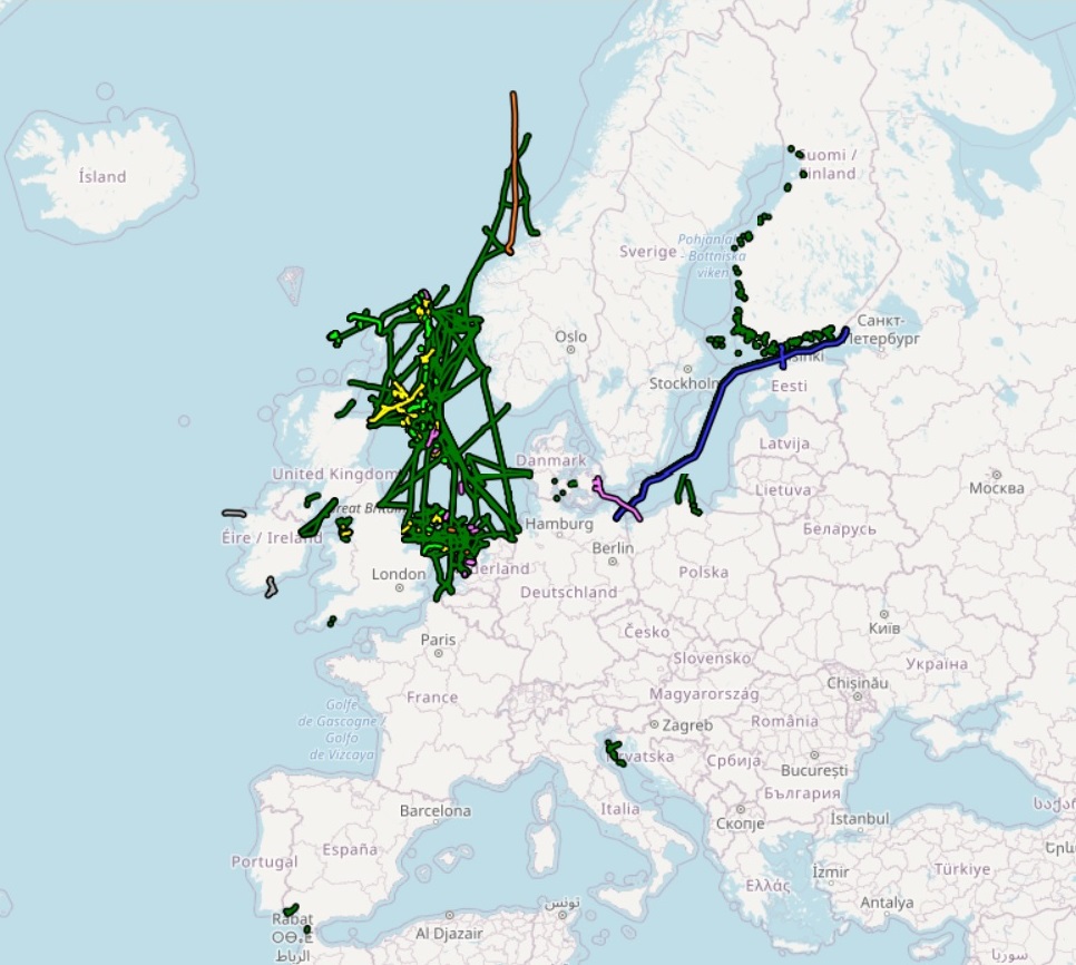
EMODnet Human Activities aims to facilitate access to existing marine data on activities carried out in EU waters, by building a single entry point for geographic information on human uses of the ocean. The portal makes available information such as geographical position, spatial extent of a series of activities related to the sea, their temporal variation, time when data was provided, and attributes to indicate the intensity of each activity. The data are aggregated and presented so as to preserve personal privacy and commercially-sensitive information. The data also include a time interval so that historic as well as current activities can be included.
- OnLine resource
-
EMODnet_HA_Pipelines_20230705.zip
(
WWW:DOWNLOAD
)
ZIP (File Geodatabase / Shapefile)
- OnLine resource
-
pipelines
(
OGC:WMS
)
Pipelines
- OnLine resource
-
emodnet:pipelines
(
OGC:WFS
)
Pipelines
- Distribution format
-
-
Esri geodatabase
(gco:nilReason="unknown">)
-
Esri shapefile
(gco:nilReason="unknown">)
-
Esri geodatabase
(gco:nilReason="unknown">)
- Hierarchy level
- Dataset
Conformance result
- Date (Publication)
- 2008-12-04
- Explanation
- See the referenced specification
- Pass
- Yes
Conformance result
- Date (Publication)
- 2010-12-08
- Explanation
- See the referenced specification
Conformance result
- Date (Publication)
- 2009-12-15
- Explanation
- See the referenced specification
- Pass
- Yes
- Statement
- Data were retrieved from different sources. Validation and quality assurance remain up to primary data sources, while harmonization is carried out by Cogea. For further information on validation and quality assurance, it is suggested that primary data sources are contacted. Generally speaking, data are to be considered very reliable, because they come from national sources officially in charge for their collection. When a pipeline has multiple sources (e.g the pipeline crosses more countries seas), it may appear as two or more different lines which do not perfectly overlap and have different attributes. This is because it is not possible to harmonize the geometric component of the data, as each source reports a slightly different pipeline's path and there is no way to know which one is more accurate.
Overviews
Spatial extent
Provided by
