 Catalogue PIGMA
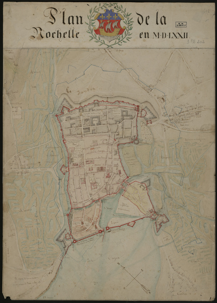
Plan de La Rochelle en MDLXXII_3PL202
Thème : Plan de La Rochelle en MDLXXII.
Date.edition : 1840
Auteur.nom : Jourdan, Jean-Baptiste-Ernest
Auteur.date : 1811-1871
Interêt : 1572 Jolie. Couleur. Fortification et port avant le siège. Et chenal. Précurseur du bassin à flot (un chenal). Réseau hydro-fluvial autour de la Rochelle.
Editeur : Plan manuscrit de l'écriture de J.-B.-E. Jourdan. V. 2403.
Echelle :
Taille : en coul. ; 34 x 47 cm
Lieu d'archivage : Michel Crépeau, Patrimoine, Reserve A 3 PL 202. Exclu du prêt, consultation sur place
Numéro d'archive : Plan Carte (N° 4600039579)
Indices : 944.64
Référence : 3 PL 202
Simple
- Date (Creation)
- 2016-09-05
- Date (Publication)
- 2017-01-30
- Date (Revision)
- 2017-01-30
- Identifier
- FR-180-089-013-03720-LIENSs_dypomar_3_PL_202_20161229
- Credit
- LIttoral ENvironnement et Sociétés - La Rochelle Université / CNRS
- Theme
-
- La Rochelle ; MDLXXI ; Jourdan
- GEMET - INSPIRE themes, version 1.0
-
- Régions maritimes
- Use limitation
- Utilisation libre sous réserve de mentionner la source (a minima le nom du producteur) et la date de sa dernière mise à jour.
- Access constraints
- Intellectual property rights
- Access constraints
- Other restrictions
- Other constraints
- Pas de restriction d’accès publique
- Classification
- Unclassified
- Spatial representation type
- grid Grid
- Metadata language
- Français
- Character set
- utf8 UTF8
- Topic category
-
- Imagery base maps earth cover
- Society
- Environment
))
))
))
- Begin date
- 1572-01-01
- End date
- 1572-01-01
- Reference system identifier
- EPSG / Lambert 93 / 7.4
- Reference system identifier
- INSPIRE RS registry / grégorien
- Distribution format
-
-
GeoTIFF
(
)
-
GeoTIFF
(
)
- OnLine resource
-
pyramid_1572
(
OGC:WMS
)
pyramid_1572
- Hierarchy level
- Dataset
- Statement
-
Carte réalisée par Jourdan, Jean-Baptiste-Ernest (1811-1871) (auteur présumé).
Carte réf. 3 PL 202 fournie par la Médiathèque d’agglomération de La Rochelle en format numérique.
Géoréférencer le 05/09/2016 par N. Volto du LIENSs (4 points, transformation du 1er ordre, affine, avec le logiciel Arcgis (ESRI) version 10.3.1).
- File identifier
- b72d2b8d-b134-4590-8f4c-e09b731e2eae XML
- Metadata language
- Français
- Character set
- UTF8
- Hierarchy level
- Dataset
- Hierarchy level name
- Série de données
- Date stamp
- 2025-05-15T23:51:59.559486Z
- Metadata standard name
- ISO 19115-3 - SEXTANT
- Metadata standard version
- 1.0
Overviews
Spatial extent
Provided by
