 Catalogue PIGMA
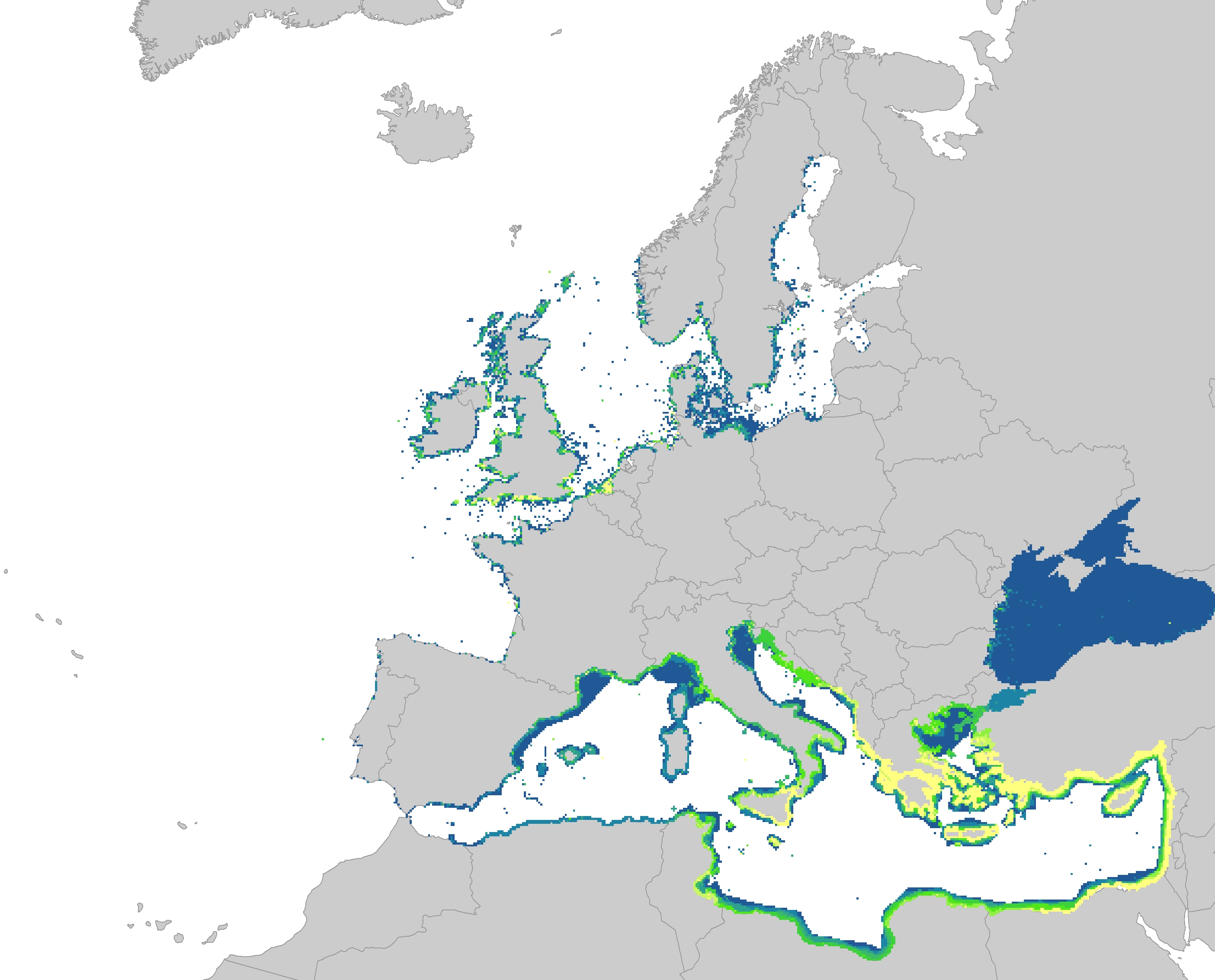
Introduction of non-indigenous species in Europe Seas, Jan. 2020
The dataset represents the introduction of non-indigenous species in European seas. Non-indigenous species are species that have been spread as a result of human activities to areas where they do not belong naturally. The main concern are the invasive species, which are defined as causing a significant negative impact on biodiversity as well as serious economic and social consequences.
The dataset has been prepared first by individually mapping each aquatic invasive species that had a distinctive distribution area, which had been provided by several non-indigenous species online databases. The distribution of the species were then resampled into the EEA 10 km grid and summed together, showing the number of non-indigenous species per grid cell. The temporal reference of the dataset covers the last 30 years (1989 - 2018).
This dataset has been prepared for the calculation of the combined effect index, produced for the ETC/ICM Report 4/2019 "Multiple pressures and their combined effects in Europe's seas" available on: https://www.eionet.europa.eu/etcs/etc-icm/etc-icm-report-4-2019-multiple-pressures-and-their-combined-effects-in-europes-seas-1.
Simple
- Date (Creation)
- 2019-05-01
- Date (Publication)
- 2020-01-27
- Edition
- 01.00
- Identifier
- eea_r_3035_10_km_intro-aqua-nis_p_1989-2018_v01_r00
Point of contact
- Maintenance and update frequency
- As needed
- Keywords
-
- Keywords
-
- GEMET
-
- pressure
- sea
- introduction of plant species
- introduction of animal species
- aquatic animal
- environmental pressure
- Continents, countries, sea regions of the world.
-
- Black Sea
- Iceland Sea
- Adriatic Sea
- Northeast Atlantic Ocean (40W)
- Kattegat
- Baltic Sea
- North Sea
- Norwegian Sea
- Barents Sea
- Celtic Sea
- Bay of Biscay
- Ionian Sea
- English Channel
- Mediterranean Sea
- Spatial scope
-
- European
- EEA topics
-
- Biodiversity
- Sustainability challenges
- Seas and coasts
- Sous-regions marines
-
- /Métropole
- /Métropole/Manche mer du Nord
- /Métropole/Mers Celtiques
- /Métropole/Golfe de Gascogne
- /Métropole/Méditerranée occidentale
- Thématiques - SIMM
-
- /Etat du Milieu/Espèces
- Type de jeux de donnée - ODATIS
-
- /Données dérivées/Produits composites
- Access constraints
- Other restrictions
- Other constraints
- no limitations to public access
- Use constraints
- Other restrictions
- Other constraints
- License CC-BY 4.0 (https://creativecommons.org/licenses/by/4.0/). Copyright holder: European Environment Agency (EEA).
- Spatial representation type
- grid Grid
- Distance
- 10 km
- Metadata language
- English
- Topic category
-
- Environment
- Oceans
))
- Begin date
- 1989-01-01
- End date
- 2018-12-31
- Unique resource identifier
- EPSG:3035
- Distribution format
-
-
GeoTIFF
(
)
-
GeoTIFF
(
)
- OnLine resource
- https://sdi.eea.europa.eu/webdav/datastore/public/eea_r_3035_10_km_intro-aqua-nis_p_1989-2018_v01_r00/ ( EEA:FOLDERPATH )
- OnLine resource
- Direct download ( WWW:URL )
- OnLine resource
- https://water.discomap.eea.europa.eu/arcgis/rest/services/Marine/Pressures_Invasive_non_indigenous_species/MapServer ( ESRI:REST )
- Hierarchy level
- Dataset
Conformance result
- Date (Publication)
- 2010-12-08
- Explanation
- See the referenced specification
- Statement
-
The dataset was made by first individually mapping each aquatic invasive species that had a distinctive distribution area. The distinctive distribution areas for all species were based on information from various non-indigenous species online databases:
• Algaebase.org
• Nobanis.org
• Marinespecies.org
• Cabi.org
• Europe-aliens.org
• Ciesm.org
• Invasions.si.edu/nemesis/
• iucn.org
• iucngisd.org/gisd/
• Eol.org
• Marlin.ac.uk
The distribution was mapped according to the information from the aforementioned databases into the EEA 10 km grid.
If the species was observed only occasionally in the area, it was not considered sufficient for the distribution of that area. If the species was reported ‘often observed’ in the area, the area was included in its distribution. The Mediterranean area was also supplemented by information on the distribution of non-indigenous species provided by local experts.
All species layers were summed together into one raster, showing the number of non-indigenous species per grid cell.
- File identifier
- cc8c0653-59e7-4f20-aa05-5f8ecb720fee XML
- Metadata language
- English
- Character set
- UTF8
- Hierarchy level
- Dataset
- Date stamp
- 2025-10-09T11:15:17.256086Z
- Metadata standard name
- ISO 19115/19139
- Metadata standard version
- 1.0
Overviews
Spatial extent
Provided by
