 Catalogue PIGMA
EMODnet Human Activities, Fisheries, Fishing Intensity
Simple
- Date (Publication)
- 2020-02-26
- Date (Revision)
- 2025-03-03
- Date (Creation)
- 2020-02-16
- Identifier
- EMODnet_HA_Fisheries_Fishing_Intensity_20250303
- GEMET - INSPIRE themes, version 1.0
-
- Agricultural and aquaculture facilities
- GEMET - Concepts, version 2.4
-
- Fisheries
- Access constraints
- Other restrictions
- Other constraints
- No limitations on public access
- gmd:useconstraints
- otherRestrictions
- Other constraints
- Creative Commons CC-BY 4.0 https://creativecommons.org/licenses/by/4.0/
- gmd:useconstraints
- otherRestrictions
- Other constraints
- This data was downloaded from the EMODnet Portal (https://emodnet.ec.europa.eu/en/). The data originator is Cogea Srl.
- Spatial representation type
- Vector
- Metadata language
- EnglishEnglish
- Topic category
-
- Economy
))
- Begin date
- 1950-01-01
- End date
- 2016-12-31
- Reference system identifier
- EPSG:4326
- Reference system identifier
- ISO 19108 calendar
- Distribution format
- Transfer size
- 0
- OnLine resource
-
EMODnet Human Activities
(
WWW:LINK
)
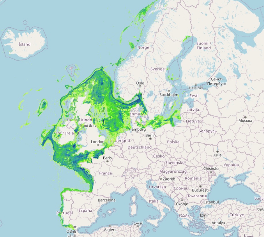
EMODnet Human Activities aims to facilitate access to existing marine data on activities carried out in EU waters, by building a single entry point for geographic information on human uses of the ocean. The portal makes available information such as geographical position, spatial extent of a series of activities related to the sea, their temporal variation, time when data was provided, and attributes to indicate the intensity of each activity. The data are aggregated and presented so as to preserve personal privacy and commercially-sensitive information. The data also include a time interval so that historic as well as current activities can be included.
- OnLine resource
-
EMODnet_HA_Fisheries_FishingIntensity_20250303.zip
(
WWW:DOWNLOAD
)
ZIP (File Geodatabase)
- OnLine resource
-
fishingbeamtrawls
(
OGC:WMS
)
Average MW Fishing hours: Beam trawls
- OnLine resource
-
fishingbottomottertrawls
(
OGC:WMS
)
Average MW Fishing hours: Bottom otter trawls
- OnLine resource
-
fishingbottomseines
(
OGC:WMS
)
Average MW Fishing hours: Bottom seines
- OnLine resource
-
fishingdredges
(
OGC:WMS
)
Average MW Fishing hours: Dredges
- OnLine resource
-
fishingpelagic
(
OGC:WMS
)
Average MW Fishing hours: Pelagic trawls and seines
- OnLine resource
-
fishingstaticgears
(
OGC:WMS
)
Average MW Fishing hours: Static gears
- OnLine resource
-
fishingsubsurface
(
OGC:WMS
)
Average Subsurface Swept Area Ratio
- OnLine resource
-
fishingsurface
(
OGC:WMS
)
Average Surface Swept Area Ratio
- OnLine resource
-
emodnet:fishingbeamtrawls
(
OGC:WFS
)
Average MW Fishing hours: Beam trawls
- OnLine resource
-
emodnet:fishingbottomottertrawls
(
OGC:WFS
)
Average MW Fishing hours: Bottom otter trawls
- OnLine resource
-
emodnet:fishingbottomseines
(
OGC:WFS
)
Average MW Fishing hours: Bottom seines
- OnLine resource
-
emodnet:fishingdredges
(
OGC:WFS
)
Average MW Fishing hours: Dredges
- OnLine resource
-
emodnet:fishingpelagic
(
OGC:WFS
)
Average MW Fishing hours: Pelagic trawls and seines
- OnLine resource
-
emodnet:fishingstaticgears
(
OGC:WFS
)
Average MW Fishing hours: Static gears
- OnLine resource
-
emodnet:fishingsubsurface
(
OGC:WFS
)
Average Subsurface Swept Area Ratio
- OnLine resource
-
emodnet:fishingsurface
(
OGC:WFS
)
Average Surface Swept Area Ratio
- Hierarchy level
- Dataset
Conformance result
- Date (Publication)
- 2008-12-04
- Explanation
- See the referenced specification
Conformance result
- Date (Publication)
- 2009-12-15
- Explanation
- See the referenced specification
Conformance result
- Date (Publication)
- 2010-12-08
- Explanation
- See the referenced specification
- Statement
- Validation and quality assurance remain up to primary data sources, e.g. ICES, while the harmonization is carried out by Cogea. For further information on validation and quality assurance, it is suggested that primary data sources are contacted. Generally speaking data are to be considered very reliable, because they come from the source officially in charge for their collection.The yearly Ecoregions ICES's data (shapefiles) on fishing intensity are harmonized, imported into a single geodatabase, organised in two different tables (Effort: Average MW fishing hours by gear type, SAR: Average surface and subsurface swept area ratio) and a single C-Squares feature class (polygons). The tables are related to the feature class via relationship classes (C-square field). Date fields have also been added. All information is pre-validated by ICES.
Overviews
Spatial extent
Provided by
