 Catalogue PIGMA
Error variance-covariance, trends, accelerations and uncertainties of regional mean sea level estimated from satellite altimetry
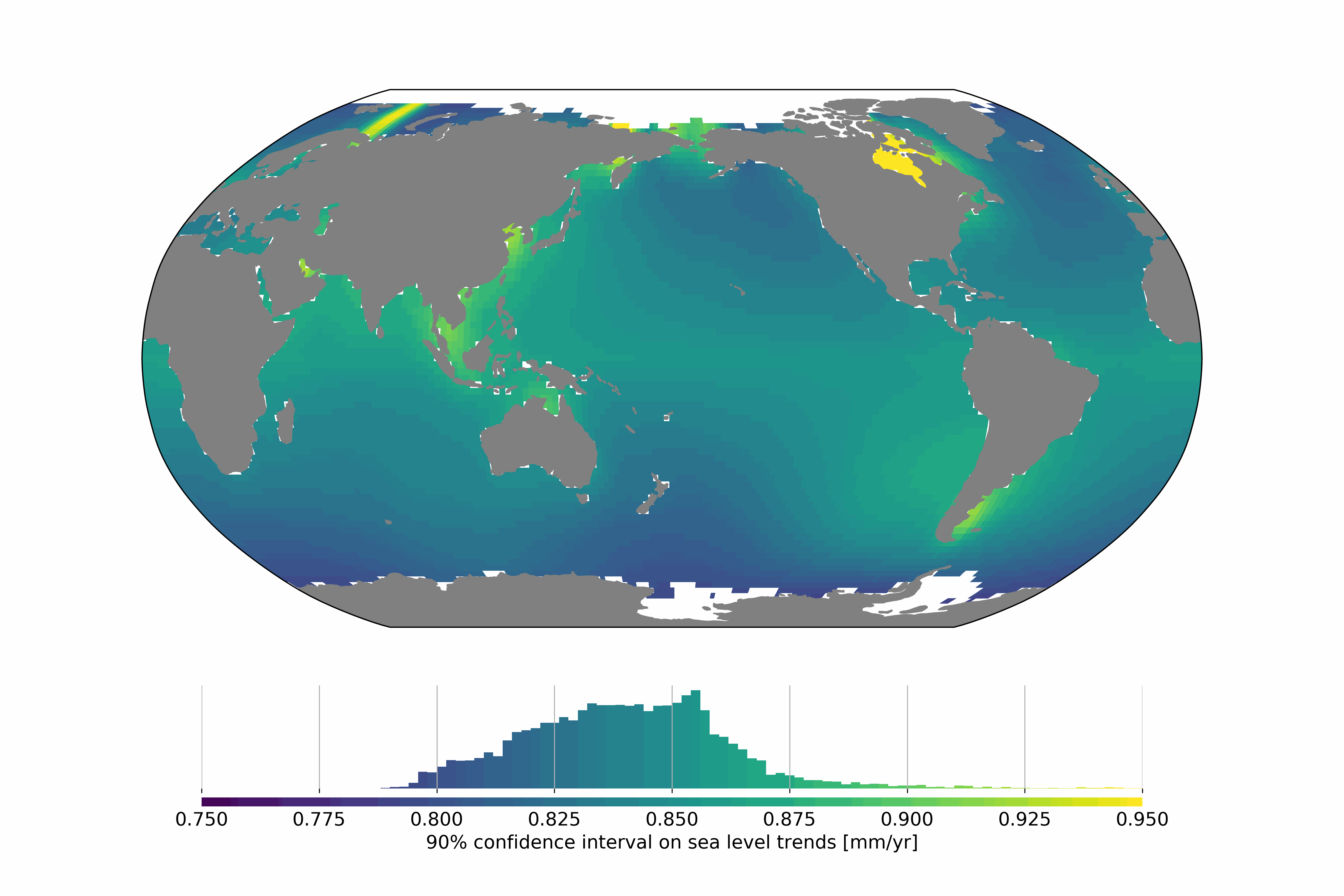
Satellite altimetry missions provide a quasi-global synoptic view of sea level over more than 25 years. The satellite altimetry constellation is used to build sea level maps and regional sea level indicators such as trends and accelerations. Estimating realistic uncertainties on these quantities is crucial to address some current climate science questions such as climate change detection and attribution or regional sea level budget closure for example. Previous studies have estimated the uncertainty for the global mean sea level (GMSL), but no uncertainty information is available at regional scales. In this study we estimate a regional satellite altimetry error budget and use it to derive maps of confidence intervals for local sea rise rates and accelerations. We analyze 27 years of satellite altimetry maps and derive the satellite altimetry error variance-covariance matrix at each grid point, prior to the estimation of confidence intervals on local trends and accelerations at the 90% confidence level using extended least squares estimators. Over 1993–2019, we find that the average local sea level trend uncertainty is 0.83 mm.yr-1 with local values ranging from 0.78 to 1.22 mm.yr-1. For accelerations, uncertainties range from 0.057 to 0.12 mm.yr-2, with a mean value of 0.063 mm.yr-2.
Change history:
- 2020/07/08: initial dataset submission over 1993-2018
- 2020/10/21: 1993-2019 update and addition of error levels
Simple
- Date (Publication)
- 2020-11-12
- Date (Revision)
- 2025-06-05
- Other citation details
- Prandi Pierre, Meyssignac Benoit, Ablain Michaël, Spada Giorgio, Ribes Aurélien (2020). Error variance-covariance, trends, accelerations and uncertainties of regional mean sea level estimated from satellite altimetry. SEANOE. https://doi.org/10.17882/74862
- Credit
- We thank ESA and CNES for their support.
- Theme
-
- satellite altimetry
- error covariance
- sea level
- uncertainties
- Physical oceanography
- Use limitation
- CC-BY (Creative Commons - Attribution)
- Use constraints
- Other restrictions
- Date (Publication)
- 2025
- Unique resource identifier
- 10.5194/egusphere-2025-1216
- Association Type
- Cross reference
- Initiative Type
- Study
- Date (Publication)
- 2021
- Unique resource identifier
- 10.1038/s41597-020-00786-7
- Association Type
- Cross reference
- Initiative Type
- Study
- Metadata language
- English
- Topic category
-
- Oceans
))
- Begin date
- 1993
- End date
- 2019
- Distribution format
-
-
NC, NETCDF
(
)
-
NC, NETCDF
(
)
- OnLine resource
-
Quality controlled data
(
WWW:DOWNLOAD-1.0-link--download
)
1993-2019 data - 47 MB
- OnLine resource
-
Processed data
(
WWW:DOWNLOAD-1.0-link--download
)
1993-2018 data [RESTRICTED] - 42 MB
- OnLine resource
- DOI of the product ( WWW:LINK-1.0-http--metadata-URL )
- OnLine resource
- Seanoe ( rel-canonical )
- Hierarchy level
- Dataset
- File identifier
- seanoe:74862 XML
- Metadata language
- English
- Character set
- UTF8
- Hierarchy level
- Dataset
- Date stamp
- 2025-06-05
- Metadata standard name
- ISO 19115:2003/19139
- Metadata standard version
- 1.0
Overviews
Spatial extent
Provided by
