 Catalogue PIGMA
Global Extreme Wind Radiometer Level 3 Dataset for SMOS WIND Project
“SMOS Level 3 daily wind speed” (SMOS L3WS) products are daily composite maps of the collected SMOS L2 swath wind products for a specific day, provided with the same grid than the Level 2 wind data (SMOS L2WS NRT) but separated into ascending and descending passes. SMOS L3WS products are available the day after from sensing and are generated in NetCDF-4 format as described in the "SMOS Wind Data Service Product Description Document" (http://www.smosstorm.org/Document-tools/SMOS-Wind-Data-Service-Documentation ).
Simple
- Date (Creation)
- 2023-06-20
- Date (Publication)
- 2023-11-23
- Identifier
- CER_L3_WND_GLO_025_SMOS_SMOSWIND / 1.0
- Status
- final final
- Use limitation
- None
- Access constraints
- unrestricted
- Use constraints
- Other restrictions
- Other constraints
- CC-BY (Creative Commons - Attribution)
- Other constraints
-
Near-Real Time Surface Wind Speed from SMOS satellite and ancillary data on a 0.25 degree resolution grid.
These data were obtained from the ESA-IFREMER-ODL SMOS Wind NRT Data Service project. Dataset accessed [YYYY-MM-DD]. DOI : 10.12770/37d97217-9c8e-4870-989c-9de60eb8aebe
- Spatial representation type
- grid Grid
- Distance
- 25 km
- Topic category
-
- Oceans
N
S
E
W
))
- Geographic identifier
- Global
- Begin date
- 2018-05-01
- Reference system identifier
- http://www.opengis.net/def/crs/EPSG/0/4326
- Distribution format
-
-
NetCDF 4
(
)
-
NetCDF 4
(
)
OnLine resource
No information provided.
- OnLine resource
-
User guide
(
WWW:LINK
)
Esa reference portal
- OnLine resource
- Digital Object Identifier (DOI) ( DOI )
- Hierarchy level
- Dataset
- Attribute description
- composite
- Processing level code
- L3 /
- File identifier
- 37d97217-9c8e-4870-989c-9de60eb8aebe XML
- Metadata language
- English
- Character set
- UTF8
- Hierarchy level
- Dataset
- Date stamp
- 2025-11-30T19:02:55.004822Z
- Metadata standard name
- ISO 19115-3:2018 - Remote Sensing
Overviews
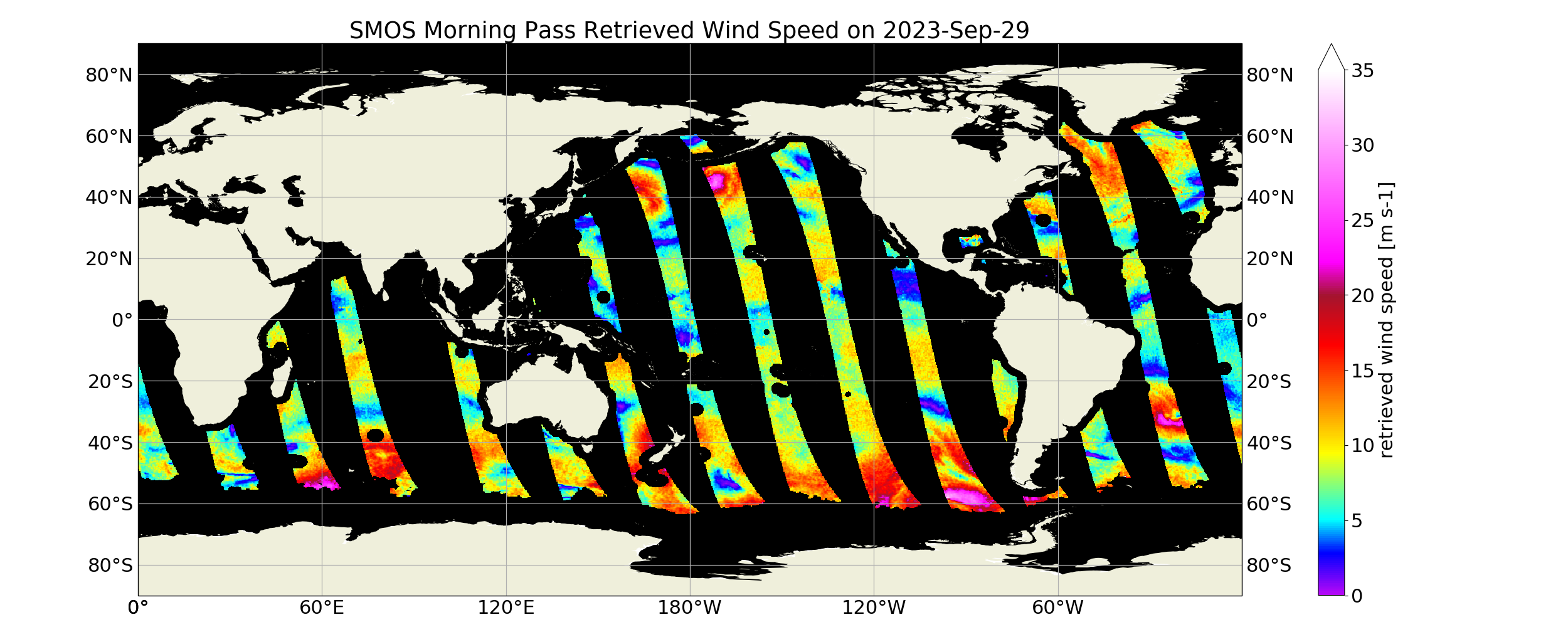
L3 SMOS WIND global pass
Spatial extent
N
S
E
W
Provided by

Associated resources
Not available