 Catalogue PIGMA
Hydrodynamic and sediment transport MARS3D-MUSTANG model - Gironde Estuary and the adjacent continental shelf
Hydrodynamic and sediment transport simulations in the Gironde Estuary and the adjacent continental shelf based on MARS3D-MUSTANG model using curvilinear mesh grid, 2015 realistic forcing and hourly output time steps
Simple
- Date (Publication)
- 2019-01-25
- Identificateur
- FR-330-715-368-00032-IFR_MODEL_HYDRO_SEDIM_MARS3D-MUSTANG-GIRONDE_ESTUARY_2019
- Identificateur
- DOI:10.12770/47a4c8af-1e27-4cb8-bdad-fde530007e94
- Reconnaissance
- IFREMER - Unité Dynamiques des Écosystèmes Côtiers (DYNECO / DHYSED)
Editeur (publication)
Ifremer, Scientific Information Systems for the sea
+33 (0)2 98.22.49.16
+33 (0)2 98.22.46.44
http://data.ifremer.fr/SISMER
IFREMER Centre de Bretagne
ZI Pointe du diable
CS 10070
, PLOUZANE , 29280 , France+33 (0)2 98.22.46.44
http://data.ifremer.fr/SISMER
Auteur
IFREMER
-
Diaz Melanie
Centre Bretagne - ZI de la Pointe du Diable - CS 10070 - 29280 Plouzané
,
Brest
,
France
02 98 22 40 40
- Thèmes Sextant
-
- /Physical Environment/Coastal Hydrodynamics
- GEMET - INSPIRE themes, version 1.0
-
- Oceanographic geographical features
- Limitation d'utilisation
- CC-BY (Creative Commons - Attribution)
- Contraintes d'accès
- Licence
- Contraintes d'utilisation
- Licence
- Type de représentation spatiale
- grid Raster
- Distance de résolution
- 1000 meter
- Langue
- English
- Jeu de caractères
- utf8 Utf8
- Catégorie ISO
-
- Océans
N
S
E
W
))
- Date de début
- 2015-01-01
- Date de fin
- 2016-01-01
- Nom du système de référence
- EPSG / WGS 84 (EPSG:4326) / 8.6
- Format (encodage)
-
-
(
4
)
-
(
4
)
- Ressource en ligne
- /home/ref-ocean-coastal-model/GIRONDE/curvigironde_hydrosed ( NETWORK:LINK )
- Ressource en ligne
-
Lien de téléchargement
(
WWW:DOWNLOAD
)
Lien de téléchargement
- Ressource en ligne
- https://doi.org/10.1029/2019JC015643 ( WWW:LINK-1.0-http--publication-URL )
- Ressource en ligne
- Digital Object Identifier (DOI) ( DOI )
- Niveau
- Jeu de données
- Généralités sur la provenance
- The MARS3D hydrodynamic model is coupled with the sedimentary module MUSTANG to simulate sediment transport dynamics. Based on this model, a configuration has been developed using an orthogonal curvilinear mesh grid covering the Gironde Estuary with its tributaries and the adjacent continental shelf. The vertical grid is discretized in 10 equidistant sigma layers. The model is forced by realistic forcing of the year 2015 (wind, waves, tide, surges, river liquid and solid discharges). The sediment transport module computes the spatial and temporal variations of sand and mud mixtures under the effect of hydrodynamic forcing. In the water column, it solves the advection-diffusion equation for 5 classes of particles chosen to be representative of the natural characteristics of sediment particles in the domain. The sediment initial distribution was uniform and a spin-up year prior to the analysis period was computed in order to ensure the model relevance and to let the simulated waves and currents redistribute the sediment over the domain. Both simulated year parameterization and results are available here.
- Identifiant de la fiche
- 47a4c8af-1e27-4cb8-bdad-fde530007e94 XML
- Jeu de caractères
- Utf8
- Type de ressource
- Jeu de données
- Date des métadonnées
- 2025-05-15T22:13:36.715709Z
- Nom du standard de métadonnées
- ISO 19115-3 - SEXTANT
- Version du standard de métadonnées
- 1.0
Point de contact
IFREMER
-
Diaz Melanie
Centre Bretagne - ZI de la Pointe du Diable - CS 10070 - 29280 Plouzané
,
Brest
,
France
02 98 22 40 40
Aperçus
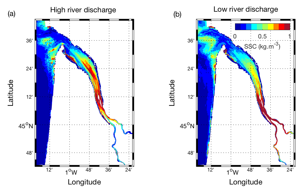
Illustration_SSC_crue_etiage_slope100_2804_2308.png
Étendue spatiale
N
S
E
W
Fourni par

Ressources associées
Not available