 Catalogue PIGMA
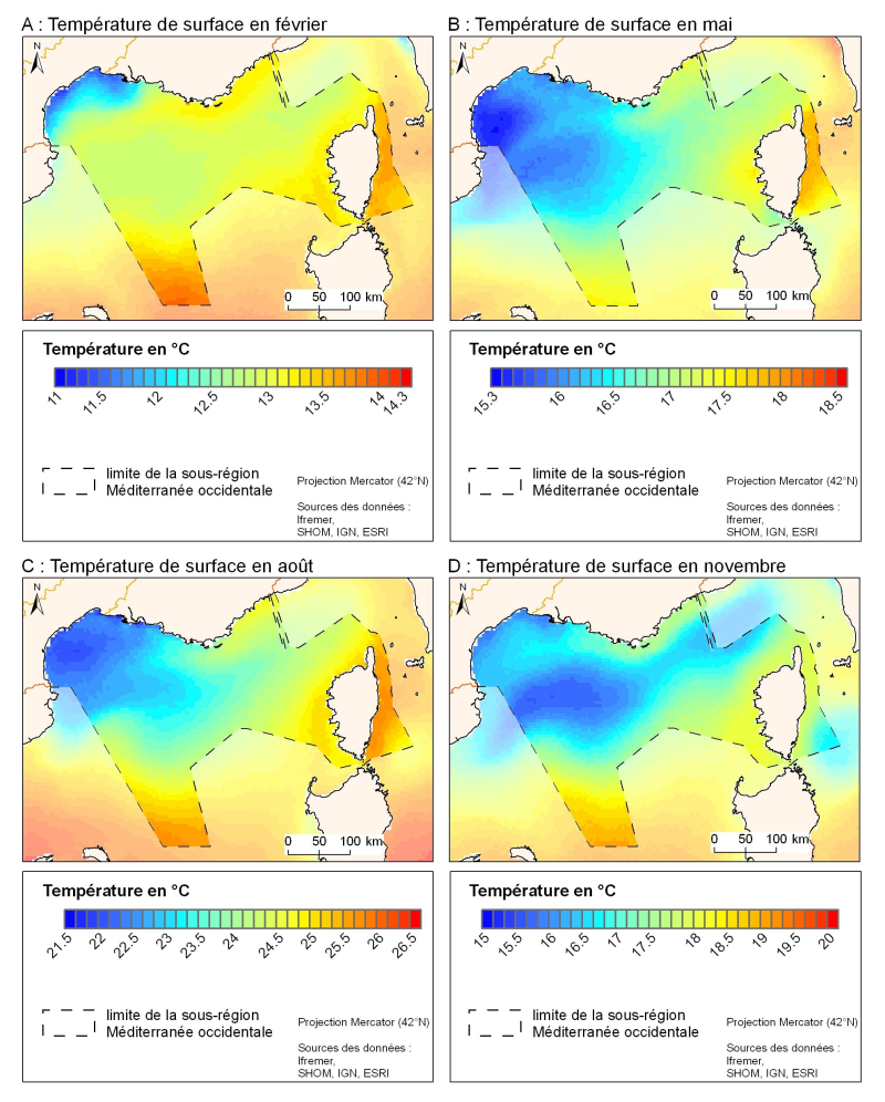
Climatologie mensuelle de la température de surface à partir d'images satellites
Monthly climatology of surface temperature from satellite images
Simple
- Date (Publication)
- 2001-11-01
- Identifier
- month-EUR-L4UHRfnd-IBIROOS-v01-fv01-OIAVHRR
- Credit
- Ifremer, MEDAR/MEDATLAS
02 98 22 48 64
-
Thèmes Sextant
-
-
/Milieu physique/Climatologie/Physical Environment/Climatology
-
- Theme
-
-
répartition spation-temporelle ; température de surface ; imagerie satellitairespatio-temporal distribution ; surface temperature ; satellite imagery
-
- Discipline
-
-
ClimatologieClimatology
-
-
GEMET - INSPIRE themes, version 1.0
-
-
Caractéristiques géographiques océanographiquesOceanographic geographical features
-
- Place
-
-
MéditerranéeMediterranean Sea
-
-
Sous-regions marines
-
-
/Métropole/Méditerranée occidentaleWestern Mediterranean
-
- Access constraints
- Copyright
- Use constraints
- Copyright
-
Other constraintsOther constraints
-
accès libre, tout publicfree access, all public
- Classification
- Unclassified
- Spatial representation type
- grid Grid
- Metadata language
- Français
- Character set
- utf8 UTF8
- Topic category
-
- Climatology, meteorology, atmosphere
- Oceans
))
- Reference system identifier
- EPSG / WGS84 géographiques / 7.4
- Distribution format
-
-
Netcdf( )
-
- OnLine resource
- site web du projet Medatlas/Medar ( WWW:LINK )
- OnLine resource
- site web du projet Medatlas/Medar ( WWW:LINK )
- OnLine resource
- site internet Ifremer dédié à la Directive Cadre Stratégie pour le Milieu Marin ( WWW:LINK )
- OnLine resource
-
carthothèque DCSMM
(
WWW:LINK
)
Régime de la température et de la salinitéSystem of temperature and salinity
- Hierarchy level
- Dataset
- Statement
-
Yannice Faugère, Pierre Le Borgne et Hervé Roquet (2001) Réalisation d'une climatologie mondiale de la température de surface de la mer à échelle fine. La Météorologie N° 35 novembre 2001. http://hdl.handle.net/2042/35926.
Climatomogie MEDAR/MEDATLAS. http://modb.oce.ulg.ac.be/backup/medar/medar.html
- File identifier
- 58d91bed-ee7d-4368-84bf-920b5e9de77c XML
- Metadata language
- Français
- Character set
- UTF8
- Hierarchy level
- Series
- Hierarchy level name
- Ensemble de jeux de données
- Date stamp
- 2025-05-15T22:30:53.21746Z
- Metadata standard name
- ISO 19115-3 - SEXTANT ISO 19115-3 - SEXTANT
- Metadata standard version
- 1.0
Overviews
Spatial extent
Provided by
