 Catalogue PIGMA
Water quality (WFD) - french surface water bodies (Loire-Brittany, Seine-Normandy basins)
Simple
- Date (Publication)
- 2023-01-20
- Identifier
- DOI:10.12770/5ff27e38-392a-4bab-b4de-a7909f1a49e3
- Credit
-
FISH INTEL Project - Interreg EU Channel-Manche
Eau France - SANDRE
Ministère de la Transition Écologique et Solidaire
- Thèmes Sextant
-
- /Physical Environment
- GEMET - INSPIRE themes, version 1.0
-
- Sea regions
- Keywords
-
- Water quality WFD
- Use limitation
- Open Licence
- Access constraints
- Copyright
- Use constraints
- Copyright
- Other constraints
-
Re-use of content is permitted free of charge, provided that the sources (Ministère de la Transition Ecologique et Solidaire, France Eau (SANDRE) and FISH INTEL Interreg EU Channel-Manche sources) are acknowledged.
Open Licence.
DO NOT USE FOR NAVIGATION.
- Spatial representation type
- vector Vector
- Denominator
- 25000
- Metadata language
- English
- Character set
- utf8 UTF8
- Topic category
-
- Oceans
))
- Unique resource identifier
- EPSG:2154
- Geometric object type
- Surface
- Distribution format
-
-
(
)
-
(
)
- OnLine resource
- Site internet du projet FISH INTEL ( null )
- OnLine resource
- FISH INTEL Website - University of Plymouth ( null )
- OnLine resource
-
Réglementation des pêches cartographiée
(
WWW:LINK
)
MTES
- OnLine resource
- https://sextant.ifremer.fr/services/wfs/fishintel ( OGC:WFS )
- OnLine resource
-
Qualite_eau_France_FISHINTEL
(
OGC:WMS
)
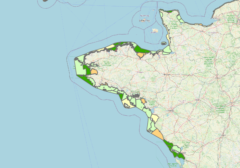
Qualité de l'eau (DCE) - Masses d'eau côtières françaises (Bassins Loire-Bretagne
- Hierarchy level
- Dataset
Domain consistency
Conformance result
- Date (Publication)
- 2010-12-08
- Explanation
- See the referenced specification
- Statement
- Water quality data for surface water bodies in the Loire-Brittany and Seine-Normandy basins according to the Water Framework Directive (2000/60/EC). A first layer of raw data listing the coastal water bodies in metropolitan France was obtained from the Government's data site (available online: https://geo.data.gouv.fr/fr/datasets/877903a1a5bf6d2bea4d171201e5180982cffc2f ). Data on coastal water quality were then obtained from the Cartograph- Eau France website (available online at https://cartograph.eaufrance.fr/donnees/203574/2015). The data set was linked to obtain a water quality data layer (classified according to official status: Very good; Good; Moderate; Poor; Bad) per coastal water body in the Channel area (France). The data was reworked as part of the FISH INTEL Interreg EU Channel project (https://fishintel.ifremer.fr/) to produce a map of marine ecosystem services and habitats in the Channel. These data are part of the catalogue ''FISH INTEL - Fisheries Innovation for sustainable INTerchannEL resources''.
- File identifier
- 5ff27e38-392a-4bab-b4de-a7909f1a49e3 XML
- Metadata language
- English
- Character set
- UTF8
- Hierarchy level
- Dataset
- Date stamp
- 2025-05-15T22:36:05.537534Z
- Metadata standard name
- ISO 19115-3 - SEXTANT ISO 19115-3 - SEXTANT
- Metadata standard version
- 1.0
Overviews
Spatial extent
Provided by
