 Catalogue PIGMA
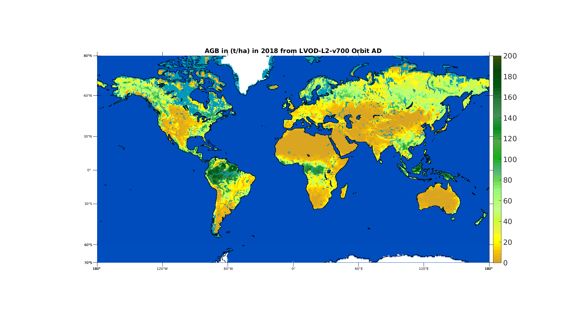
CATDS-CEC-SM L3 AGB Aggregated yearly global map of vegetation above ground biomass (AGB) obtained from SMOS' satellite optical thickness
Simple
- Date (Publication)
- 2023-01-11T12:00:00+01:00
- Identifier
- CATDS-PDC-L3AGB-YEARLY-SMOS-CCI
- Credit
- CATDS (CNES, IFREMER, CESBIO)
- Thèmes Sextant
-
- /Imagery/Satellite Imagery
- GEMET - INSPIRE themes, version 1.0
-
- Orthoimagery
- Keywords
-
- Biomasse terrestre
- Télédétection micro ondes passives
- données ouvertes
- bande L
- GEMET themes
-
- research
- Use limitation
- CC-BY (Creative Commons - Attribution)
- Access constraints
- Copyright
- Use constraints
- Copyright
- Spatial representation type
- grid Grid
- Distance
- 25000 meter
- Metadata language
- Français
- Character set
- utf8 UTF8
))
- Begin date
- 2010-01-12T00:00:00+00:00
- Unique resource identifier
- EPSG:6933
- Number of dimensions
- 2
- Dimension name
- Column
- Dimension size
- 1388
- Resolution
- 25000 m
- Dimension name
- Row
- Resolution
- 25000 m
- Cell geometry
- Area
- Transformation parameter availability
- No
- Distribution format
-
-
(
)
-
(
)
- OnLine resource
-
Technical note SO-TN-CB-GS-0108
(
WWW:LINK
)
Technical note describing the products (yearly global AGB maps from SMOS
- OnLine resource
- HTTP access ( WWW:DOWNLOAD )
- OnLine resource
-
FTP access
(
WWW:DOWNLOAD
)
All products are also available by FTP : server ftp.ifremer.fr, login ext-catds-cecsm, passwd catds2010, path Land_products/L4_Above_Ground_Biomass
- OnLine resource
- Digital Object Identifier (DOI) ( DOI )
- Hierarchy level
- Dataset
Domain consistency
Conformance result
- Date (Publication)
- 2010-12-08
- Explanation
- See the referenced specification
- Statement
-
1 Introduction
Monitoring Above Ground Biomass (AGB) is of prime importance to track the vegetation health and
estimate the carbon stocks, among other applications. The Vegetation Optical Depth (VOD) derived from
the multi-angular Brightness Temperatures (TB) measured by the Soil Moisture and Ocean Salinity (SMOS)
mission can be processed in order to get a global AGB estimation
- Description
-
As input to the AGB estimation processing chain, the LVOD from the SMOS Level-2 (L2) MIR_SMUDP2 v700 products were used. Each SMOS L2 MIR_SMUDP2 binary product contains the LVOD (amongst other variables including latitude, longitude, soil moisture, probability of radio frequencyinterference, probability distribution of Chi2 and quality flags) for a half orbit (ascending or descending) onthe ISEA grid.
The AGB reference is the ESA Biomass Climate Change Initiative (CCI) 2018 AGB map. For each 100mx100m pixel, this product gives an estimation of the AGB in Mg.ha−1. To reach this high resolution, SAR, LiDAR and optic remote sensing data were combined. Readers will find more details about the CCI AGB maps in the product user guide.
The SMOS L2 products are distributed as binary files gathering all samples for a half orbit on the ISEA grid. The pre-processing starts with the creation of daily ascending and descending maps of SMOS L2 measurements by concatenating all products sensed the same day. On the DGG nodes where multiple measurements were acquired the same day, the measurement of highest quality and closest to the subtrack selected. These cases mainly happen at high latitudes. A land mask is also applied on the daily maps. Finally, the variables are interpolated to the EASE grid 2.0 Global, equal area projection (EPSG: 6933).
Once the daily maps for the ascending and descending orbits are created, the data is filtered based on the level of Radio-Frequency Interference (RFI) and the quality of the data retrieval quantified by the probability of Chi2 (Chi2_P field). The SMOS data affected by more than 20% of RFI and where the probability of the Chi2 is below 5% are filtered out. This allows to keep only the best quality retrievals. Then, the filtered daily LVOD over land are averaged on a yearly basis, merging ascending and descending orbits altogether. Averaging over a year irons out the effects on L-VOD due to diurnal and seasonal variations of the vegetation water content.
After applying the steps described in the previous parts, there are the global and yearly SMOS LVOD maps on one hand and the AGB reference map for a particular year on the other hand. Both quantities are on the same grid, with the same land mask. A link between them now needs to be established. Then, the fitted curve with the optimized set of parameters is applied on the LVOD for the reference year. The derived estimated AGB is then compared to the reference AGB in order to quantify the differences.
Finally, the optimized logistic function is applied on all SMOS LVOD yearly averages. The result is a global and yearly AGB time series on the EASE grid written in a NetCDF file. There is one file per reference AGB map.
The data are distributed in the NetCDF file format. The NetCDF format is extremely convenient to store and distribute multidimensional data, called variables. A NetCDF file is self describing which means that it contains information around the raw data such as when data elements were captured, the units etc. A NetCDF file is approximately 83Mo.
- Rationale
- Produce yearly global AGB maps from SMOS data
- File identifier
- 95f76ff0-5d89-430d-80db-95fbdd77f543 XML
- Metadata language
- English
- Character set
- UTF8
- Hierarchy level
- Dataset
- Date stamp
- 2025-06-24T08:28:36.396127Z
- Metadata standard name
- ISO 19115-3 - SEXTANT
- Metadata standard version
- 1.0
Overviews
Spatial extent
Provided by
