 Catalogue PIGMA
Marine protected or significant areas in the North Atlantic
Simple
- Date (Publication)
- 2019-08-14
- Identifier
- FR-330-715-368-00032-IFR_MARBEC_ATLAS_Protected_Areas
- Identifier
- DOI:10.12770/debcbd09-4a36-48f3-a7c8-38f313eedd1b
- Credit
- Horizon 2020 ATLAS project (EU)
- Thèmes Sextant
-
- /Regulation and Management/Technical and Management Zonations/Sensitive Zones
- GEMET - INSPIRE themes, version 1.0
-
- Protected sites
- Use limitation
- CC-BY-NC-SA (Creative Commons - Attribution, Pas d’utilisation commerciale, Partage dans les mêmes conditions)
- Access constraints
- License
- Use constraints
- License
- Spatial representation type
- grid Grid
- Distance
- 25 km
- Metadata language
- English
- Character set
- utf8 UTF8
- Topic category
-
- Oceans
- Environment
))
- Reference system identifier
- +proj=aea +lat_1=43 +lat_2=62 +lat_0=30 +lon_0=-30 +x_0=0 +y_0=0 +datum=WGS84 +units=m +no_defs +ellps=WGS84 +towgs84=0,0,0
- Number of dimensions
- 2
- Dimension name
- Row
- Dimension size
- 273
- Resolution
- 25 km
- Dimension name
- Column
- Dimension size
- 491
- Resolution
- 25 km
- Cell geometry
- Area
- Transformation parameter availability
- No
- OnLine resource
-
IFR_MARBEC_ATLAS_PROTECTION_CAT1_NORTHATL
(
OGC:WMS
)
Protection category 1 - North Atlantic
- Protocol
- COPYFILE
- Name
- IFR_MARBEC_ATLAS_PROTECTION_CAT1_NORTHATL
- Description
- Protection category 1 - North Atlantic
- OnLine resource
- Convention on Biological Diversity (2019). Ecologically or Biologically Significant Marine Areas. https://www.cbd.int/ebsa/ebsas ( WWW:LINK )
- OnLine resource
- Food and Agriculture Organization of the United Nations (2019) General Fisheries Commission for the Mediterranean - GFCM - Fisheries Restricted Areas (FRAs). http://www.fao.org/gfcm/data/maps/fras ( WWW:LINK )
- OnLine resource
- North East Atlantic Fisheries Commission (2019) VMEs and Closed Area Coordinates Coordinates. https://www.neafc.org/closures/coordinates ( WWW:LINK )
- OnLine resource
- Northwest Atlantic Fisheries Organization (2019) Vulnerable Marine Ecosystems (VME) Closures. https://www.nafo.int/Fisheries/VME ( WWW:LINK )
- OnLine resource
- UNEP-WCMC, & IUCN. (2019). Marine Protected Planet [On-line], [July, 2019]. Cambridge, UK. https://www.protectedplanet.net ( WWW:LINK )
- OnLine resource
- Fisheries and Oceans Canada (2020). Oceans Act Marine Protected Areas. ( WWW:LINK )
- OnLine resource
- Fisheries and Oceans Canada (2020). Other Effective Area-Based Conservation Measures. ( WWW:LINK )
- OnLine resource
- Institute of Marine Research (2019). Map “coralmpa”: cold-water corals MPAs in the EEZ of Norway. ( WWW:LINK )
- OnLine resource
- NOAA (2017). Marine Protected Areas Inventory. ( WWW:LINK )
- OnLine resource
- https://safmc.net/ecosystem-management/mapping-and-gis-data/ ( WWW:LINK )
- OnLine resource
- UNEP-WCMC, & IUCN (2020). Marine Protected Planet [On-line], [April,2020]. Cambridge, UK. ( WWW:LINK )
- OnLine resource
-
IFR_MARBEC_ATLAS_PROTECTION_CAT2_NORTHATL
(
OGC:WMS
)
Protection category 2 - North Atlantic
- Protocol
- COPYFILE
- Name
- IFR_MARBEC_ATLAS_PROTECTION_CAT2_NORTHATL
- Description
- Protection category 2 - North Atlantic
- OnLine resource
-
IFR_MARBEC_ATLAS_PROTECTION_CAT3_NORTHATL
(
OGC:WMS
)
Protection category 3 - North Atlantic
- Protocol
- COPYFILE
- Name
- IFR_MARBEC_ATLAS_PROTECTION_CAT3_NORTHATL
- Description
- Protection category 3 - North Atlantic
- OnLine resource
-
DOI of the dataset
(
DOI
)
DOI of the dataset
- Hierarchy level
- Dataset
Domain consistency
Conformance result
- Date (Publication)
- 2010-12-08
- Explanation
- See the referenced specification
- Statement
-
The dataset of current conservation designations originated from the Regional Fisheries Management Organisations (RFMOs) for fishing closures (FAO, 2019; NAFO, 2019; NEAFC, 2019), the World Database on Protected Areas (WDPA) for MPAs (UNEP-WCMC & IUCN, 2019), national MPAs databases (US: NOAA and SAFMC; Canada: Fisheries and Oceans Canada; Norway: Institute of Marine Research), and the Convention on Biological Diversity for EBSAs (CBD, 2019). The data was categorized and extracted in 25km * 25 km gridsquares of the raster grid used for the ATLAS spatial prioritization.
Source data references:
Convention on Biological Diversity (2019). Ecologically or Biologically Significant Marine Areas. https://www.cbd.int/ebsa/ebsas ;
Fisheries and Oceans Canada (2020). Oceans Act Marine Protected Areas. https://open.canada.ca/data/en/dataset/a1e18963-25dd-4219-a33f-1a38c4971250 ;
Fisheries and Oceans Canada (2020). Other Effective Area-Based Conservation Measures. https://open.canada.ca/data/en/dataset/44769543-7a23-4991-a53f-c2cf7c7a946f ;
Food and Agriculture Organization of the United Nations (2019). General Fisheries Commission for the Mediterranean - GFCM - Fisheries Restricted Areas (FRAs). http://www.fao.org/gfcm/data/maps/fras ;
Institute of Marine Research (2019). Map “coralmpa”: cold-water corals MPAs in the EEZ of Norway. http://maps.imr.no/geoserver/web/. ;
NOAA (2017). Marine Protected Areas Inventory. https://marineprotectedareas.noaa.gov/dataanalysis/mpainventory/ ;
North East Atlantic Fisheries Commission (2019). VMEs and Closed Area Coordinates Coordinates. https://www.neafc.org/closures/coordinates ;
Northwest Atlantic Fisheries Organization (2019). Vulnerable Marine Ecosystems (VME) Closures. https://www.nafo.int/Fisheries/VME ;
South Atlantic Fishery Management Council (2020). Deep-water coral Habitat Areas of Particular Concern (HAPC) and grouper Special Management Zones (SMZs) coordinates. https://safmc.net/ecosystem-management/mapping-and-gis-data/ ;
UNEP-WCMC, & IUCN (2020). Marine Protected Planet [On-line], [April,2020]. Cambridge, UK. https://www.protectedplanet.net .
- Description
-
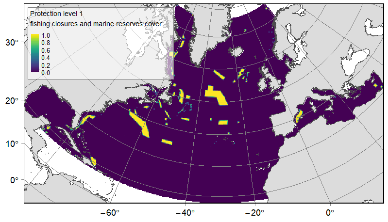
The Atlantic high seas total 40 fishing closures designated and controlled by the Northwest Atlantic Fisheries Organization (NAFO, 2019) and the North East Atlantic Fisheries Commission (NEAFC, 2019). In the Mediterranean Sea, the General Fisheries Commission for the Mediterranean (GFCM) manages four Fishing Restricted Areas (FAO, 2019), three of them constituting full bottom fishing closures (GFCM, 2006), and a fourth one (Gulf of Lion) where bottom fishing is restricted but not forbidden (GFCM, 2009).
The marine subset of the WDPA gathers delimitation together with protection and management information about MPAs worldwide (UNEP-WCMC & IUCN, 2019). The database was extracted for the study area extent (N= 3390 MPAs). The MPAs dataset was categorised using several sources of information describing each MPA: the last updated status (‘status’ field); the environment type (‘marine’ field); the IUCN category (‘IUCN’ field); the existence of no-take zones (‘no-take’ field). First, 77 areas were eliminated from the dataset: (1) the MPAs with a ‘Proposed’ value in the ‘status’ field since they are not yet approved by the authorities; and (2) the MPAs with a ‘terrestrial’ value in the ‘marine’ field because they do not apply to the marine environment (e.g. coastal sand hills of cliffs). Then, a ‘marine reserve’ category (N=290) was defined as MPAs with a presence of no-take zones (‘no take’ field with ‘all’ or ‘part’ value), or with a restrictive IUCN category (‘IUCN’ field with a ‘cat Ia’ or ‘cat Ib’ value). The remaining MPAs, likely under weaker protection regimes, were pooled in the second category ‘other MPAs’ (N=3027).
The WDPA database was compared to available national or regional (e.g. MedPan for the Mediterranean) databases in order to identify discrepancies and gaps of referencing in the international dataset. For the European Union, Mediterranean and Caribbean countries, the WDPA seemed sufficiently informed. Discrepancies were found in Canada and the US, for which the WDPA lacked many MPAs, and in a smaller extent for cold-water corals MPAs of Norway. The MPAs dataset used in this study was hence complemented with MPAs boundaries for Norway, the USA and Canada. Delimitations of cold-water coral reefs MPAs on the coast of Norway (Institute of Marine Research, 2019) were downloaded, these 18 MPAs were classified as marine reserves as bottom-fishing is prohibited. For Canada, the Marine Act MPAs and the Other Effective Area-Based Conservation Measures (OEABCMs) boundaries were downloaded from Fisheries and Oceans Canada. For the Marine Act MPAs, management plans and fishing regulations were inspected individually for classifying the MPAs between ‘marine reserves’ where bottom-fishing was prohibited (N=13), and ‘other MPAs’ where management regulations were less restrictive (N=16). For the OEABCMs, the ‘PROHIBITIO’ attribute field, listing the prohibited activities for each area, was used to classify areas between ‘marine reserves’ where bottom-fishing was prohibited (N=29), and ‘other MPAs’ where management regulations were less restrictive (N=12). This classification was verified and validated by fisheries experts from Fisheries and Oceans Canada. Finally, for the USA, two datasets were used to list the Atlantic coast MPAs: the national inventory of protected areas from the NOAA (NOAA, 2017) and the protected areas managed by the South Atlantic Fishery Management Council in North and South Carolina, Georgia and Florida (SAFMC, 2020). For the NOAA dataset, seasonal MPAs were eliminated, together with MPAs without fisheries restrictions, that consisted mostly on very coastal areas and estuaries (N=425). Then, MPAs that had the highest protection level with full fishing closure (“no access”, “no impact” and “no take” areas), MPAs where commercial fishing was prohibited, and MPAs that had an IUCN category “Ia”, were classified as ‘marine reserves’ (N=145). The remaining areas, with lower restrictions, were classified as ‘other MPAs’ (N=392). Concerning the SAFMC, the deep-water coral Habitat Areas of Particular Concern (HAPC), that constitute bottom-fishing closures, were classified as ‘marine reserves’ (N=6), while grouper Special Management Zones (SMZs) were classified as “other MPAs”.
Delimitations of all currently designated EBSAs were downloaded from the CBD website (CBD, 2019). The identification of EBSAs in the North Atlantic, done through regional workshops, was completed for the North-West, Caribbean, and Mediterranean regions. The North-East Atlantic regional workshop has not yet reached an agreement, thus EBSAs are absent on this part of the basin.
Additional references:
GFCM. (2006). Recommendation GFCM/30/2006/3 on the establishment of fisheries restricted areas to protect deep-sea sensitive habitats. ;
GFCM. (2009). Recommendation GFCM/33/2009/1 on the establishment of a fisheries restricted area in the Gulf of Lion to protect spawning aggregations and deep-sea sensitive habitats.
- Rationale
- Inventory of protected and significant areas
- Description
- Three categories were delineated according to relative levels of protection, from the highest to the lowest: (1) high protection level for areas providing high restriction of human activities offered by NAFO, NEAFC or GFCM fishing closures and the ‘marine reserves’; (2) medium protection level for areas with lower restrictions of use offered by the GFCM fishing restricted area of the Gulf of Lion and the ‘other MPAs’; (3) low protection level attributed to EBSAs, which are not associated with any legislation. In case of overlapping protection measures, only the higher protection category was kept for the overlapping area, and the corresponding area in the polygons of lower protection category was erased. At the scale of the North Atlantic (all depths included), this resulted in 1,119,604 km² (3.29% of the North Atlantic) for the category 1 (high protection); 2,930,945 km² (8.61%) for the category 2 (MPAs with lower protection); and 5,473,237km² (16.08%) for the category 3 (EBSAs). On the ATLAS planning area (depths below 3,500m excluded), this corresponds to 898,523km² (4.56% of the planning area) for the category 1; 1,724,196km² (8.75%) for the category 2; and 1,266,878km² (6.43%) for the category 3.
- Rationale
- Categorization in protection levels
- Description
- For each of the three levels of protection, the rasterize function was used to extract the relative cover of protected areas in 25km *25km gridsquares in the R environment, from 0 (absence of the protection category in the cell), to 1 (cell 100% covered by the protection category). Values of the cells that were out of the study zone were set to NA.
- Rationale
- Extraction of protection levels on the ATLAS grid
- File identifier
- debcbd09-4a36-48f3-a7c8-38f313eedd1b XML
- Metadata language
- English
- Character set
- UTF8
- Hierarchy level
- Dataset
- Date stamp
- 2025-05-16T09:14:26.433597Z
- Metadata standard name
- ISO 19115-3 - SEXTANT
- Metadata standard version
- 1.0
Overviews
Spatial extent
Provided by
