 Catalogue PIGMA
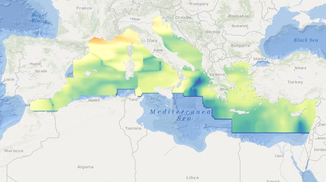
MEDSEA_CH6_Product_3 / Maps of average TRIX indices calculated from Mediterranean sea surface data for the periods 2008-2012, 1998-2002, and 1993-1997
Simple
- Date (Creation)
- 2016-09-21T00:00:00
- Date (Revision)
- 2016-12-08T18:00:00
- Identifier
- DOI:10.12770/2b7e5cda-4953-492a-ae30-857f277efda2
- Purpose
- Map of seasonal “eutrophication algorithm/indicator” from in situ data and FOR THE PAST 10 YEARS
- Credit
- EMODnet Medsea Checkpoint
- Used by challenges
-
- MedSea - CH06 - Marine Environment
- Processing level of characteristics
-
- High level analyzed
- Production mode
-
- Delayed
- GEMET - INSPIRE themes, version 1.0
-
- Oceanographic geographical features
- Theme
-
- eutrophication index
- historical data sets
- maps
- trends
- Mediterranean Sea
- Use limitation
- open and free
- Aggregate Datasetindentifier
- 390a41fa-28d9-4863-ae13-466db7e9f1b7
- Association Type
- Cross reference
- Initiative Type
- specification
- Aggregate Datasetindentifier
- f278a4e8-e8c6-4c1c-b267-50f7f9bdcabe
- Association Type
- Cross reference
- Initiative Type
- upstreamData
- Aggregate Datasetindentifier
- cacbbebf-c23f-40d9-bf83-c9fcd005c720
- Association Type
- Cross reference
- Initiative Type
- upstreamData
- Aggregate Datasetindentifier
- 8080431e-a113-44d8-8d08-232cdb1e8dc0
- Association Type
- Cross reference
- Initiative Type
- upstreamData
- Aggregate Datasetindentifier
- e1ed08c1-6131-450c-a577-f89b51040bb4
- Association Type
- Cross reference
- Initiative Type
- upstreamData
- Aggregate Datasetindentifier
- 96c8658a-10de-437d-8295-434edcdffe0e
- Association Type
- Cross reference
- Initiative Type
- upstreamData
- Aggregate Datasetindentifier
- 8b580f14-8ca9-4b47-af0e-57300cb6c21b
- Association Type
- Cross reference
- Initiative Type
- upstreamData
- Aggregate Datasetindentifier
- 032a71fb-2249-4c79-8d30-51aba2d19c50
- Association Type
- Cross reference
- Initiative Type
- upstreamData
- Aggregate Datasetindentifier
- 4523421b-e814-4bd7-94ab-fad383430601
- Association Type
- Cross reference
- Initiative Type
- upstreamData
- Aggregate Datasetindentifier
- da8a7d75-c1ef-4bb1-8f84-6a02eedc0e58
- Association Type
- Cross reference
- Initiative Type
- upstreamData
- Aggregate Datasetindentifier
- 199a2c00-c460-4aab-92b4-9069c97bc411
- Association Type
- Cross reference
- Initiative Type
- upstreamData
- Aggregate Datasetindentifier
- 49817c96-48c9-4c87-9eec-27ead88fe37e
- Association Type
- Cross reference
- Initiative Type
- upstreamData
- Aggregate Datasetindentifier
- 9ff13db1-a368-4b50-a09d-81ad690d5024
- Association Type
- Cross reference
- Initiative Type
- upstreamData
- Aggregate Datasetindentifier
- a5450981-db61-4f39-9ab7-ce3db054cac1
- Association Type
- Cross reference
- Initiative Type
- upstreamData
- Aggregate Datasetindentifier
- 1142bafe-f909-43ce-8fac-0eb569a829da
- Association Type
- Cross reference
- Initiative Type
- upstreamData
- Aggregate Datasetindentifier
- e5ab50e3-8c72-4fc3-87bc-d9696d071a10
- Association Type
- Cross reference
- Initiative Type
- upstreamData
- Aggregate Datasetindentifier
- 5ed84eb3-77bd-4912-b7c0-06f15abe0fa7
- Association Type
- Cross reference
- Initiative Type
- upstreamData
- Aggregate Datasetindentifier
- 1b0db429-5d86-4d62-920b-ff31cd9d61a8
- Association Type
- Cross reference
- Initiative Type
- upstreamData
- Aggregate Datasetindentifier
- adf10368-e5a1-42fa-9edc-4465f1dabfdf
- Association Type
- Cross reference
- Initiative Type
- upstreamData
- Aggregate Datasetindentifier
- 65856bec-7740-430b-b5dd-ac7d639d7c2c
- Association Type
- Cross reference
- Initiative Type
- upstreamData
- Aggregate Datasetindentifier
- 4b22a8fd-7a5d-4149-9755-fb5956a0c371
- Association Type
- Cross reference
- Initiative Type
- upstreamData
- Aggregate Datasetindentifier
- 8d0e7720-f183-4eff-be16-19542fdec11e
- Association Type
- Cross reference
- Initiative Type
- upstreamData
- Spatial representation type
- grid Grid
- Metadata language
- English
- Character set
- utf8 UTF8
- Topic category
-
- Oceans
))
- Begin date
- 1993-01-01T00:00:00
- End date
- 2012-12-31T00:00:00 After
Vertical extent
- Minimum value
- 0
- Maximum value
- 5
- Distribution format
-
-
PDF
()
-
ESRI Shapefile
()
-
PDF
()
- OnLine resource
-
DOI of the product
(
WWW:LINK-1.0-http--metadata-URL
)
DOI of the product
- OnLine resource
-
CH6_product_3
(
OGC:OWS-C
)
Product visualization
- OnLine resource
-
Access to the website
(
WWW:LINK
)
Access to the website
- Hierarchy level
- datasetComponent
))
- Begin date
- 2003-01-01T00:00:00
- End date
- 2012-12-31T00:00:00 After
Vertical extent
- Minimum value
- 0
- Maximum value
- 5
- Other
- MEDSEA_CH6_Product_3
- Other
- Component description
- Other
- Marine water|Chlorophyll pigment concentrations in the water column|Concentration of chlorophyll-a {chl-a} per unit volume of the water body by synthesis from multiple satellite sensors|High level analyzed|Delayed
- Other
- Marine water|Dissolved oxygen parameters in the water column||High level analyzed|Delayed
- Other
- Marine water|Nitrate concentration parameters in the water column||High level analyzed|Delayed
- Other
- Marine water|Phosphate concentration parameters in the water column||High level analyzed|Delayed
- Other
- Marine water|Salinity of the water column||High level analyzed|Delayed
- Other
- Marine water|Temperature of the water column||High level analyzed|Delayed
Completeness omission
- Name of measure
- Horizontal Spatial Coverage
- Measure identification
- AP.1.1
- Measure description
- Horizontal coverage extent of product (eg : surface of the Mediterranean Sea)
Quantitative result
- Value type
- Real
- Value
- 2000000
Completeness omission
- Name of measure
- Vertical Spatial Coverage
- Measure identification
- AP.1.2
- Measure description
- Vertical coverage extent of product
Quantitative result
- Value type
- Real
- Value
- 5
Completeness omission
- Name of measure
- Temporal Coverage
- Measure identification
- AP.1.3
- Measure description
- Temporal coverage extent of product
Quantitative result
- Value type
- Integer
- Value
- 7300
Conceptual consistency
- Name of measure
- Number of Characteristics
- Measure identification
- AP.2.1
- Measure description
- Number of characteristics in product
Quantitative result
- Value type
- Integer
- Value
- 6
Thematic classification correctness
- Name of measure
- Horizontal resolution
- Measure identification
- AP.3.1
- Measure description
- Horizontal mesh size or equivalent value for the given scale of product (eg 50m for 1/50 000)
Quantitative result
- Value type
- Integer
- Value
- 8000
Thematic classification correctness
- Name of measure
- Vertical resolution
- Measure identification
- AP.3.2
- Measure description
- Average vertical sampling
Quantitative result
- Value type
- Real
- Value
- 1
gmd:DQ_DescriptiveResult
- Date / Time
- 2016-09-21T00:00:00
Thematic classification correctness
- Name of measure
- Temporal resolution
- Measure identification
- AP.3.3
- Measure description
- Temporal sampling interval of product
Quantitative result
- Value type
- Real
- Value
- 1825
Quantitative attribute accuracy
- Name of measure
- Thematic accuracy
- Measure identification
- AP.3.4
- Measure description
- Percentage error of the product and description of error concept for the product (100 words max) provided by expert
Quantitative result
- Value type
- Percentage
- Value
- 50
- Statement
- Huge gaps in time and space of simultaneous data collections of the six variables required for TRIX calculation, prevented reaching a higher accuracy.
Temporal validity
- Name of measure
- Temporal validity
- Measure identification
- AP.4.1
- Measure description
- Max elapsed time between last input data records update and product creation date
Quantitative result
- Value type
- Integer
- Value
- 365
Completeness omission
- Name of measure
- Horizontal spatial coverage error
- Measure identification
- P.APE.1.1
- Measure description
-
Percentage to which the extent of the horizontal
spatial coverage of TPD is not compliant with the DPS extent in km**2(TDP_AP_1_1 - DPS_AP_1_1)*100/DPS_AP_1_1
Quantitative result
- Value type
- Percentage
- Value
- -20
Completeness omission
- Name of measure
- Vertical spatial coverage error
- Measure identification
- P.APE.1.2
- Measure description
-
Percentage to which the extent of the vertical spatial coverage of TPD is not compliant with the DPS extent in
metres.(TDP_AP_1_2 - DPS_AP_1_2)*100/DPS_AP_1_2
Quantitative result
- Value type
- Percentage
- Value
- 0
Completeness omission
- Name of measure
- Temporal coverage error
- Measure identification
- P.APE.1.3
- Measure description
-
Percentage to which the extent of the temporal coverage of TPD is not compliant with the DPS extent in
days.(TDP_AP_1_3 - DPS_AP_1_3)*100/DPS_AP_1_3
Quantitative result
- Value type
- Percentage
- Value
- 100
Conceptual consistency
- Name of measure
- Thematic content error
- Measure identification
- P.APE.2.1
- Measure description
-
Percentage
of completeness/Incompleteness of the number of characteristcs with respect to the list in DPS(TDP_AP_2_1 - DPS_AP_2_1)*100/DPS_AP_2_1
Quantitative result
- Value type
- Percentage
- Value
- 0
Thematic classification correctness
- Name of measure
- Horizontal resolution error
- Measure identification
- P.APE.3.1
- Measure description
-
Percentage to which the product averaged horizontal mesh size or horizontal scale is not compliant with the DPS
averaged mesh size or horizontal scale(DPS_AP_3_1 - TDP_AP_3_1)*100/DPS_AP_3_1
Quantitative result
- Value type
- Percentage
- Value
- 20
Thematic classification correctness
- Name of measure
- Vertical resolution error
- Measure identification
- P.APE.3.2
- Measure description
-
Percentage to which the product averaged vertical mesh size or vertical scale is not compliant with the DPS
averaged mesh size or vertical scale(DPS_AP_3_2 - TDP_AP_3_2)*100/DPS_AP_3_2
Quantitative result
- Value type
- Percentage
- Value
- 0
Thematic classification correctness
- Name of measure
- Temporal sampling interval error
- Measure identification
- P.APE.3.3
- Measure description
-
Percentage to which the product temporal sampling interval is not compliant with the one defined in DPS
(percentage to be extracted from text of AP.3.3 measure)(DPS_AP_3_3 - TDP_AP_3_3)*100/DPS_AP_3_3
Quantitative result
- Value type
- Percentage
- Value
- -1927.7777777777778
Quantitative attribute accuracy
- Name of measure
- Thematic accuracy errror
- Measure identification
- P.APE.3.4
- Measure description
-
Compliance with the value domain of
the accuracy defined in DPS (% extracted from thematic accuracy description)TDP_AP_3_4
Quantitative result
- Value type
- Percentage
- Value
- 50
Temporal validity
- Name of measure
- Temporal validity error
- Measure identification
- P.APE.4.1
- Measure description
-
Percentage to which the elapsed time of the product is not compliant with the max elapsed time specified in
DPS.(DPS_AP_4_1 - TDP_AP_4_1)*100/DPS_AP_4_1
Quantitative result
- Value type
- Percentage
- Value
- 0
- File identifier
- 2b7e5cda-4953-492a-ae30-857f277efda2 XML
- Metadata language
- English
- Character set
- UTF8
- Hierarchy level
- Dataset
- Date stamp
- 2025-01-28T09:15:30.000819Z
- Metadata standard name
- ISO 19115-3 - Emodnet Checkpoint - Targeted Data Product
Overviews
Spatial extent
Provided by
