 Catalogue PIGMA
Level-2P Along-track Sea Level Anomaly Data Products - Version 4.0 (DUACS DT 2024)
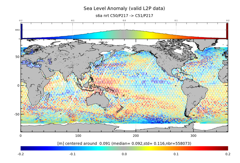
The Level-2P (L2P) products are pre-operational homogenized, mono-mission satellite altimetry datasets generated by the DUACS production system. They provide along‑track SLA data together with the full set of standardised geophysical and environmental corrections (e.g., tide‑free sea level, inverse barometer, sea‑state bias, atmospheric corrections). The L2P SLA datasets are the primary input for the higher‑order DUACS processing chain that yields the operational sea‑level (Level-3 and Level-4) products distributed by the Copernicus Marine Service (CMS) and the Copernicus Climate Change Service (C3S).
**Processing Timeliness:**
- **Near-Real-Time (NRT)**: Rapid delivery windows (under 3h – up to 24h for the newest passes) for operational marine forecasting.
- **Short Time Critical (STC)**: Intermediate latency (24h – 3 days) streams optimized for quick-turnaround cal/val and monitoring.
- **Non-Time Critical (NTC)**: Science‑quality dataset (30 days – up to 90 days) with the most stable baseline corrections; foundation for long‑term climate analyses.
The L2P SLA NRT/STC 20Hz data products version 4.0 (DUACS DT 2024 baseline) are available for the following missions: Jason-3, Sentinel‑6 Michael Freilich (MF) and SWOT.
The L2P SLA NTC 1Hz data products version 4.0 (DUACS DT 2024 baseline) are available for the following missions: ERS‑1, TOPEX/Poseidon, ERS‑2, Geosat‑Follow‑On, Jason‑1, Envisat, Jason‑2, CryoSat‑2, Haiyang‑2A, SARAL/AltiKa, Jason‑3, Sentinel‑3A, Sentinel‑3B, Sentinel‑6 Michael Freilich (MF) and SWOT.
Simple
- Date (released)
- 2024-02-29
- Date (Publication)
- 2024-03-18
- Identifier
- AVISO-2026.007 / 4.0
- Credit
- CDS-AVISO
- Status
- onGoing On going
- Centre de données ODATIS
-
- CDS-AVISO
- Keywords
-
- Sea surface Hight
- Cersat - Parameter
-
- Sea Surface Topography
- Use limitation
- Licence ouverte
- Access constraints
- License
- Use constraints
- License
- Other constraints
- Open Licence
- Unique resource identifier
- c4991050-5e27-48a1-bf78-eab3794d832a
- Association Type
- Cross reference
- Unique resource identifier
- 10.5194/essd-2025-604
- Association Type
- Cross reference
- Initiative Type
- Study
- Spatial representation type
- grid Grid
- Metadata language
- English
- Character set
- utf8 UTF8
- Topic category
-
- Oceans
))
- Begin date
- 1992-10-13
- Reference system identifier
- http://www.opengis.net/def/crs/EPSG/0/4326
- Geometric object type
- Complex
- Distribution format
-
-
NetCDF
(
4
)
-
NetCDF
(
4
)
- OnLine resource
-
Monomission L2P Altimetry Products
(
WWW:DOWNLOAD
)
THREDDS
- Protocol
- WWW:LINK
- Name
- Product Handbook
- Description
- Along-track Sea Level Anomalies Level-2 Plus (L2P) Product Handbook (all missions except Sentinel-3 & Sentinel-6)
- OnLine resource
- User guide ( WWW:LINK )
- OnLine resource
- User guide ( WWW:LINK )
- OnLine resource
-
Level-2P Along-track SLA Products
(
WWW:LINK
)
THREDDS
- OnLine resource
- Digital Object Identifier (DOI) ( DOI )
- Hierarchy level
- Dataset
- Statement
-
Contents: along-track corrected sea surface heights wrt reference ellipsoid. Datasets of 1Hz spatial resolution for all missions + datasets of 20Hz spatial resolution for Copernicus Sentinel-3A&B, Sentinel-6MF, Jason-3 in Short Time Critical (STC) and Near-Real-Time (NRT)
Use: stationary or long-term geophysical and ocean phenomenon studies.
Description: Mono altimeter satellite product, with corrections and geophysical parameters. Significant wave heights and backscatter coefficient are also provided (except for Sentinel-3A). Note that monomission products by definition are not intercalibrated at crossover points. Thus Jason-1 and Envisat data for example may not be homogeneous at a given point, since their orbits are different. Note also that these products are not corrected from Large Wavelength Error (LWE), unlike multimission Ssalto/Duacs products.
References:
Kocha, C., Pujol, M.-I., Prandi, P., Cadier, E., Philipps, S., Dibarboure, G., Maréchal, C., & Jouan, C. (2022). Analysis of the Sentinel-6A Michael Freilich L2P-L3 Sea Level Anomaly SAR-LRM bias correction. https://doi.org/10.24400/527896/A04-2022.001
- Description
- Production of the L2P SLA data products in version 4.0 (DUACS DT 2024 baseline)
- Date / Time
- v4.0 2024-02-29
- Hierarchy level
- Dataset
- Attribute description
- pass
- Processing level code
- L2P
- File identifier
- 3659a908-2ff0-4d7c-aa7d-ffbab7f5397c XML
- Metadata language
- Français
- Character set
- UTF8
- Hierarchy level
- Dataset
- Date stamp
- 2026-10-08T12:37:05.353614Z
- Metadata standard name
- ISO 19115-3:2018 - Remote Sensing ISO 19115-3:2018 - Remote Sensing
- Metadata standard version
- 1.0
Overviews
Spatial extent
Provided by
