 Catalogue PIGMA
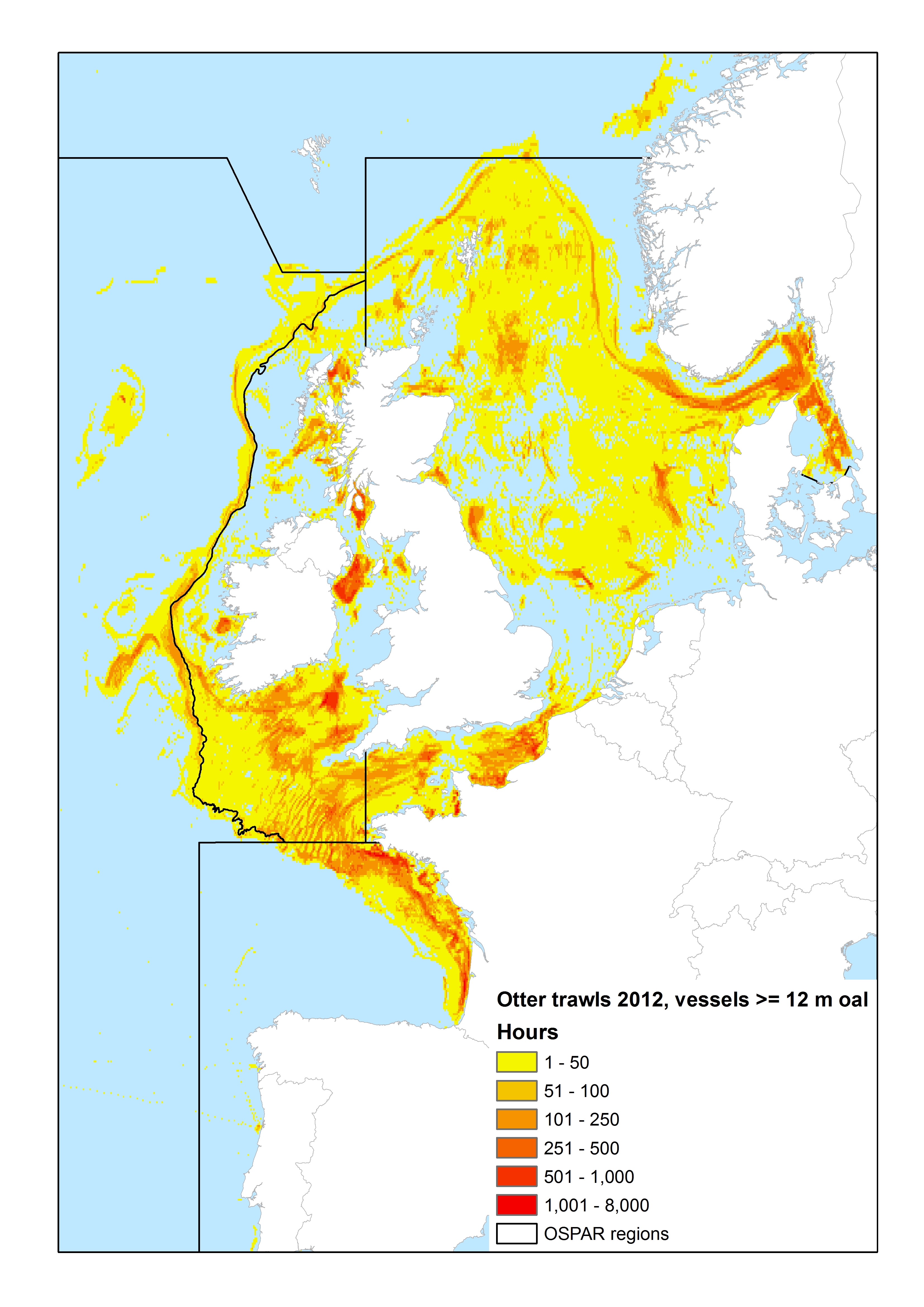
Fishing effort | Fishing Intensity | International Council for the Exploration of the Sea (ICES) | OSPAR mapping bottom fishing intensity data outputs
Simple
- Alternate title
- OSPAR mapping bottom fishing intensity data outputs
- Date
- Identifier
- Fishing effort | Fishing Intensity | International Council for the Exploration of the Sea (ICES) | OSPAR mapping bottom fishing intensity data outputs
- Other citation details
- Mapping Fishing Intensity and Effort data outputs
- Purpose
- To illustrate the spatial and temporal coverage of OSPAR bottom fishing intensity in the NE Atlantic region
- Status
- onGoing On going
edmerp
The Working Group on Spatial Fisheries Data
-
WGSFD
http://www.ices.dk/community/groups/Pages/WGSFD.aspx
http://www.ices.dk/community/groups/Pages/WGSFD.aspx
edmo
International Council for the Exploration of the Sea (ICES)
http://www.ices.dk/Pages/default.aspx
http://www.ices.dk/Pages/default.aspx
Originator
The International Council for the Exploration of the Sea
http://www.ices.dk/Pages/default.aspx
http://www.ices.dk/Pages/default.aspx
- Maintenance and update frequency
- Unknown
- Used by challenges
-
- Atlantic - CH07 - Fisheries Impact
- Environmental matrix
-
- Human activities
- Production mode
-
- Delayed
- Visibility
-
- Use of open search engines, searching by name either the data provider or the characteristics
- Policy visibility
-
- There is detailed information provided to understand data policy
- Readyness
-
- Format not proprietary and content clearly specified (e.g. autodescriptive like ODV, NetCDF CF) or at least with appropriate document describing the content
- Parameter Discovery Vocabulary (P02)
-
- Fishing effort
- GEMET - INSPIRE themes, version 1.0
-
- Sea regions
- Processing level of characteristics
-
- High level analyzed
- Data delivery mechanisms
-
- Online downloading services
- Parameter Usage Vocabulary (other)
-
- Fishing Intensity
- Agreed Parameter Groups (P03)
-
- Human activity
- Service extent
-
- Data sets are not referenced in a catalogue or are referenced in a non public catalogue
- Validation
-
- Draft
- Access constraints
- Other restrictions
- Other constraints
- Unrestricted
- Use limitation
- Open and Free. No charge
- Spatial representation type
- vector Vector
- Metadata language
- Français
- Character set
- utf8 UTF8
- Topic category
-
- Oceans
- Environment description
- The impact of fishing on benthic habitats has previously been investigated however; a conclusive classification of potentially sensitive habitats per gear type does not exist. Currently only qualitative estimates of fishery impact using broad-scale habitat maps are possible. Here a sensitivity matrix using both fishing pressure and habitat sensitivity is employed to define pressure categories. A matrix-approach used to combine sensitivity and pressure is used to predict disturbance
N
S
E
W
))
- Begin date
- 2009
- End date
- 2012 After
Vertical extent
- Minimum value
- 0
- Maximum value
- 1000
- Dimension name
- Time
- Resolution
- 5 year
- Transformation parameter availability
- Yes
- Checkpoint Availability
- Yes
- Distribution format
-
-
JPEG
()
-
XLS
()
-
JPEG
()
- OnLine resource
- Publication Reports : Data outputs ( WWW:LINK )
- OnLine resource
- OSPAR mapping bottom fishing intensity data outputs ( WWW:LINK )
- Hierarchy level
- Dataset
Domain consistency
- Name of measure
- Responsiveness
Quantitative result
- Value
- Online downloading (i.e. a few hours or less) for release
- Attribute description
- observation
- Content type
- Physical measurement
- File identifier
- 3bdc01bc-9bc9-4e0c-bc26-07b512f5c470 XML
- Metadata language
- English
- Character set
- UTF8
- Hierarchy level
- Dataset
- Hierarchy level name
- Atlantic - CH07 - Fisheries Impact
- Date stamp
- 2018-02-27T12:03:47Z
- Metadata standard name
- ISO 19115-3 - Emodnet Checkpoint - Upstream Data
- Metadata standard version
- 1.0
Overviews
OSPAR_mapping_bottom_fishing_intensity_data_outputs_2014
Spatial extent
N
S
E
W
Provided by

Associated resources
Not available