 Catalogue PIGMA
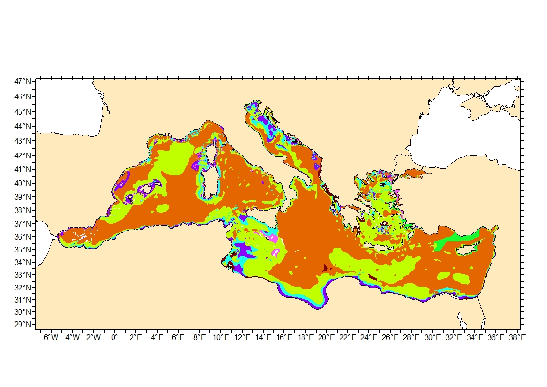
Modelled seabed sediment average grain size in the Mediterranean
Simple
- Date (Creation)
- 2020-04-01
- Date (Publication)
- 2020-04-01
- Credit
- Ifremer
- Thèmes Sextant
-
- /Physical Environment/Geology/Seabed Nature
- GEMET - INSPIRE themes, version 1.0
-
- Habitats and biotopes
- DCSMM : Descripteurs
-
- D1: Deep-sea benthic habitats
- D6: Sea-floor Integrity
- Sous-regions marines
-
- Western Mediterranean
- Thématiques - SIMM
-
- /Environmental Status/Geology
- /Environmental Status/Habitats
- Research
- Use limitation
- CC-BY-NC-SA (Creative Commons - Attribution, Pas d’utilisation commerciale, Partage dans les mêmes conditions)
- Access constraints
- Other restrictions
- Use constraints
- Copyright
- Spatial representation type
- grid Grid
- Metadata language
- English
- Character set
- utf8 UTF8
- Topic category
-
- Oceans
- Environment
))
- Reference system identifier
- EPSG / WGS 84 (EPSG:4326) / 8.6
- Number of dimensions
- 2
- Dimension name
- Vertical
- Dimension name
- Time
- Cell geometry
- Area
- Transformation parameter availability
- No
- Distribution format
-
-
(
)
-
(
)
- OnLine resource
- iso 16665 ( WWW:LINK )
- OnLine resource
- EUSeaMap.A European broad-scale seabed habitat map ( WWW:LINK )
- OnLine resource
- EUSeaMap 2019, EUNIS full detail classification ( WWW:LINK )
- OnLine resource
- Sediment_avg_grain_size_Med ( OGC:WMS )
- Protocol
- COPYFILE
- Name
- Sediment_avg_grain_size_Med
- OnLine resource
- Digital Object Identifier (DOI) ( DOI )
- Hierarchy level
- Dataset
Domain consistency
Conformance result
- Date (Publication)
- 2010-12-08
- Explanation
- See the referenced specification
- Description
-
Sediment average grain size in French Mediterranean waters was generated from sediment categories.
EUSeaMap sediment map of the Mediterranean was used to obtain sediment distribution, grain size range (mm) per sediment group and % fraction of each main sediment group (Rock, coarse and mixed sediment, mixed sediment, sand, muddy sand, sandy mud, fine mud or sandy mud, fine mud). Upper and lower boundaries for rock, pebble and clay size were derived from iso 16665 description. Fraction per category were derived from Folk (1954) sediment classification modified after EUSeaMap European broad-scale seabed habitat map description of categories (EUNIS L3 classes) for Mediterranean and Black Sea.
Folk, R. L., 1954. The distinction between grain size and mineral composition in sedimentary rock nomenclature, Jour. Geology 62, 344–359.
- Description
-
Römkens et al. (1997) equation enabling the estimation of average grain size from sediment typologie and fraction was applied:
X = exp[ 0.01 * SUM( fi * ln( mi ) ) ]
where X :average grain size (mm) ; mi : estimated average grain size of ith sediment category (mm) and ; fi : corresponding fraction of mi (%).
Römkens, M. J. M., Young, R. A., Poesen, J. W. A., McCool, D. K., El-Swaify, S. A., & Bradford, J. M., 1997. Soil erodibility factor (K). Renard KG et al., Predicting soil erosion by water: a guide to conservation planning with the Revised Universal Soil Loss Equation (RUSLE). USDA Agriculture Handbook, (703), 65-99.
- Description
-
Sediment categories were recoded with the computed average grain size and the layer was transformed in geotiff.
The categories - grain size correspondance are:
"fine mud" = 0.031525 mm, "mud" = 0.03781531 mm, "sandy mud" = 0.09243549 mm, "Fine mud or sandy mud or muddy sand" = 0.17008322 mm, "muddy sand" = 0.386289173 mm, "sand" = 0.94424275 mm, "mixed sediment" = 1.67029356 mm, "coarse & mixed sediment" = 6.34059641 mm, "Rock or other hard substrata" = 2032 mm
- File identifier
- 522f867b-f8b0-412c-8e4a-5a49980856f8 XML
- Metadata language
- English
- Character set
- UTF8
- Hierarchy level
- Dataset
- Date stamp
- 2025-05-15T22:23:49.836714Z
- Metadata standard name
- ISO 19115-3 - SEXTANT
- Metadata standard version
- 1.0
Overviews
Spatial extent
Provided by
